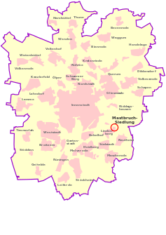
Mastbruch-Elmaussicht
|
Mastbruch-Elmaussicht
City of Braunschweig
|
|
|---|---|
| Coordinates: 52 ° 15 ′ 14 " N , 10 ° 34 ′ 43" E | |
| Height : | 76 m above sea level NN |
| Residents : | 380 (December 31, 2011) |
| Incorporation : | 1974 |
| Postal code : | 38126 |
| Area code : | 0531 |
|
Location of Elmaussicht-Mastbruch in Braunschweig
|
|
|
Reitlingstrasse
|
|
The Elmaussicht or Mastbruchsiedlung belongs, like the Lindenbergsiedlung, to the Braunschweig district of Lindenberg and the district 213 - Südstadt-Rautheim-Mascherode . Mastbruch is the official name for the statistical district with the number 51, in which 380 people live.
history
The settlement area is north of federal highway 1 and the A 39 . The name Mastbruch is derived from the earlier use of this area as a pasture. The area with its forest and bushes once belonged to the Riddagshausen monastery .
The area of the Elmaussicht used to belong to the sick wood of St. Leonhard . The broken mast came to Riddagshausen in 1281 . To the north of today's settlement was the Fritherikeroth desert , which has risen up in Rautheim. According to Bornstedt, the settlement is said to have originated around 800 and is mentioned in the dedication certificate from St. Magni . The settlement comprised about 180 acres of arable land with sandy loess soils, meadows, pastures and about three farms. At the end of the 14th century it became desolate due to agglomeration.
|
|
|
|---|---|
| The location of the mast break (" Mastbroug ") on a historical map of the city of Braunschweig around 1714–1750 |
Already from 1550 to 1620 potters from Rennelberg were mining clay here. A brick factory was built here in 1887 . When this was closed in 1918, several allotment garden associations were set up and allotments were set up. The clubs were called "Elmblick", "Freie Aussicht" and the garden club "Mastbruch" on Brodweg. In the 1920s, several residential buildings were added on Helmstedter Strasse (B 1). At the beginning of the Nazi era , the allotment garden associations were forcibly united. During the Second World War , some of the garden houses were used as emergency shelters.
After the war, in which some buildings were also destroyed here, there were "disputes" over so-called "wild development". In 1957 the development of the area was then approved, but the "Elmaussichtler" fought in vain for the status of an official settlement. On December 31, 2005, the statistical district had 420 inhabitants.
The street names were selected after locations from the Elm . Mostly single-family houses were built.
Infrastructure
The settlement belongs to the ev.-luth. Parish in Lindenberg and the Catholic parish of St. Aegidien .
coat of arms
The coat of arms is divided diagonally by a white written banner and shows the Braunschweig castle lion on a base as an outline drawing in the red field and an equally stylized tree in a green field.
In the written banner, from bottom to top, in capital letters, first “Braunschweig” and behind it, separated by a lying diamond, “Lindenberg” and underneath “Elmaussicht”, as these two settlements share the coat of arms.
The lion stands for belonging to the city of Braunschweig (with the colors red and white) and the tree for part of the name of the Lindenbergsiedlung and the Mastbruch-Elmaussicht settlement, which indicates the nearby Elm ridge.
Web links
- Article in the Süd-Nachrichten on bs-sued.de
- Elmaussicht - Mastbruchsiedlung on braunschweig.de
Individual evidence
- ↑ a b Population statistics on braunschweig.de
- ^ Wilhelm Bornstedt : On the document from 1031: The reasons for the entry of the 11th parish villages of St. Magni and their location in today's townscape. A settlement geography; in: Church council to Magni: St. Magni 1031–1981. Braunschweig 1981. p. 22.
- ↑ Elmaussicht - Mastbruchsiedlung on braunschweig.de


