
Hagen (Braunschweig)

.png)
The Hagen is the second of five soft patches in the city of Braunschweig .
history
The Hagen was founded by Heinrich the Lion after 1160 and received city rights in 1227 . The patron saint of Hagen was St. Catherine . The parish church of Hagen, St. Katharinen , was named after her. It was started in 1172, also founded by Henry the Lion. In addition to the Braunschweig lion, the coat of arms of Hagen also bears a wheel, the attribute of the patron saint.
The Hagen is located in originally swampy area. For drainage and fortification, Heinrich the Lion recruited road builders from Holland , who later laid roads, drained the ground and built on it. At that time, the Hagen Weichbild was probably enclosed by a hedge. The name Hagen suggests that , in the Middle Ages, a Hag was an area enclosed, i.e. fenced in, by a hedge .
The first street the Dutch started was Bohlweg; it served as an access road to the moor from the Altewiek soft patch . At the same time, the construction of ramparts was started, with a fortification wall being built between Hagen and Altewiek, which separated the Hagen from Altewiek. Altewiek itself had no ramparts, they were built later. Thus Altewiek was initially outside the Braunschweig ramparts. The Hagen was laid out in the typical chessboard shape, with little attention being paid to symmetry.
In 1385 a municipal scale was built on the Hagenmarkt . The Hagen town hall was once located there . It was built around 1230 and rebuilt and expanded for the first time around 1400 and again around 1578. From 1689 to 1690 the Hagenrathaus with the adjacent Hagener Gewandhaus (first mentioned in 1302) was converted into the Braunschweig Opera House . The final performance took place on September 1, 1861, and the opera house was finally demolished in 1864. The new theater building on Steinweg took over its task . The space that became vacant after the opera house was demolished was added to the Hagenmarkt; the Heinrichsbrunnen has stood here since 1874 .
In 1269 the Weichbildrat des Hagen merged with those of the old town and the new town to form a new, the so-called “common council” .
Nothing is left of the medieval residential area of the Hagen today. During the Second World War, the Hagen was largely destroyed by bombing from the air. The half-timbered houses burned completely. Usually only the outer walls remained of the massive houses. Only a few houses remained intact. The only older remains today, besides the medieval Katharinenkirche, are the renaissance portal of the old Hagenmarktapotheke and the renaissance portal of the Kalm house, which were moved to other parts of the city.
O
N

| Over 40 bombing raids during the Second World War , in particular the bombing raid of October 15, 1944 , destroyed and damaged areas of the north-eastern Braunschweig city center , between Steinweg (above), Hagenmarkt (right), Fallersleber Straße (below) and Theaterwall (left). For orientation: |
|
| 1) | The badly damaged Braunschweig Castle . |
| 2) | The castle square ; including the State Ministry in Dankwardstrasse, opposite the town hall on the left . The Dankwarderode Castle and Brunswick Cathedral can be seen on the right on Burgplatz . |
| 3) | The State Theater can be seen on the left edge of the picture . |
| 4) | The destroyed buildings of Wilhelmsgarten . |
| 5) | The badly damaged Katharinenkirche on Hagenmarkt. |
| 6) | The ruins of the Hagenmarkt pharmacy . |
| 7) | The burnt-out Bierbaum house on Fallersleber Strasse. |
The pharmacy portal is now at the Gewandhaus on the old town market . The portal of the Kalmschen house on the Opfermanntwete in the Neustadt. In contrast to other parts of the city, no traditional island was built in the Hagen, no buildings were reconstructed, and all the houses whose outer walls were preserved were rigorously demolished. The area of the Hagen was planned with a modern development, for which still intact houses were also demolished. Of the more recent structures, the ministerial building, the Braunschweig town hall, a residential building on the Ritterbrunnen, a bank building on Bohlweg (meanwhile also demolished), the building known as the Gloria-Kino on Wendenstraße, the former hospital on Wendenstraße and individual houses on Werder, remained. the Reichsstrasse and the Schubertstrasse. The Braunschweig Castle, which was still largely preserved, also fell victim to urban planning and demolition work. A department store at Langen Hof was also demolished in favor of a new building. In addition, the market hall was still preserved, but only part of the outer walls are still standing today.
coat of arms
Description: In the silver shield is a red, upright, red-tongued, black-armored lion on which a silver six-spoke wheel rests.
photos

The Katharinenkirche, parish church of Hagen

Katharinenkirche from the southeast

The Heinrichsbrunnen on the Hagenmarkt with the founder of Hagen, Heinrich the Lion

The Pauline monastery originally stood on Hagenscharn and was later used as an armory. When the monastery was demolished, the church choir was built next to the Aegidia church.
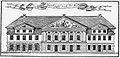
The opera house (the former Hagenrathaus after renovation in 1689/90)
.jpg)
.JPG)


literature
- Monika Zeidler: Mauernstrasse, Klint and Werder! Market and street names in Braunschweig. Pfankuch, Braunschweig 1981.
Web links
- Historical maps on the urban development of Braunschweig on the website of the city of Braunschweig, PDF, accessed on November 4, 2012
Individual evidence
- ^ A b Arnold Rabbow: New Braunschweigisches Wappenbuch. Braunschweiger Zeitungsverlag, Meyer Verlag, Braunschweig 2003, ISBN 3-926701-59-5 . P. 16.
- ↑ Monika Zeidler: Mauernstrasse, Klint and Werder! Market and street names in Braunschweig. Pfankuch, Braunschweig 1981.
Coordinates: 52 ° 16 ' N , 10 ° 32' E