
Wallring (Braunschweig)


The Wallring in Braunschweig is an urban facility around the old city and within the Umflutgräben consisting of green and parks, a ring road, residential buildings and functional buildings, the former from 1803 to the fortifications was built in the city. The redesign of the ramparts was initiated by Duke Karl Wilhelm Ferdinand (1735–1806). The architect Peter Joseph Krahe (1758–1840) played a decisive role in the design of the Wallring, who built it for representational purposes in the classicist style and laid out promenades (hence the earlier name Wallpromenaden ). Today, the Wallring is of historical, cultural, ecological, urban development and architectural importance, the streets are largely listed and there are a large number of cultural monuments along the street, but the numerous green areas and parks are also used for local recreation. Buildings in the classicist and historicist styles dominate the Wallring, as well as in many places modern buildings from the 1950s and 1960s, on which the old structures previously fell victim to the air raids of the Second World War. The streets are often laid out axially and the squares are round or oval in shape. One of these oval places is the Löwenwall . Due to the loose development, the Wallring and its distinctive shape can be easily recognized from the air as a green ring around the densely built-up city center. The term wall ring can stand for the entire wall system as well as in the narrower sense for the road ring on the wall. In 2010 the demand arose that the city should apply to include the Wallring as a UNESCO World Heritage Site .
history
The baroque city fortifications
The basis for today's ramparts was the redesign of Braunschweig's city fortifications at the end of the 17th century according to the baroque ideal. In 1671 the city came back into the possession of the Dukes of Braunschweig-Lüneburg, who now wanted to provide the city with modern fortifications and commissioned the military architect Johann Caspar von Völcker (1655–1730) to build it. Von Völcker was trained in the Netherlands and France and designed the fortifications from 1692 in the Dutch manner and created a system of 16 bastions, ditches and forward ravelins . Soldiers and workers worked on the construction of the new fortification. The number of city gates was reduced, the Magnitor and the New Town Gate were closed. The new fortification was now up to 200 meters wide. Then there was the glacis in front of the outer trenches. Georg Möring succeeded the late von Völcker. The new fortification was completed in 1741. The complex fastening should only have a short service life. Only in the Seven Years' War between 1756 and 1763 was it able to fulfill its purpose of protecting and defending the city. There was a final reinforcement of the fortification.
Redesign of the ramparts
Preliminary work
With a change in warfare, the fortifications became ineffective in the course of the 18th century. The now useless ramparts served as garden and pasture land, but caused considerable maintenance costs. The bastions were neglected and the trenches silted up. So in 1769 the "wall demolition" was decided. 1775 began with the planting of timber.
From 1780 the baroque fortifications were torn down in an orderly manner, and individual bastions for the construction of parks and gardens were to be sold later. In connection with an urban redevelopment in the 1780s, the medieval city gates were removed. In order to be able to redesign the ramparts in their entirety, the ducal decree was first issued in 1792 that no ramparts could be sold for the time being. In 1797 a commission headed by Friedrich Wilhelm Culemann was set up to deal with the demolition of walls. In order to be able to finance the estimated costs of the demolition, the planning provided for the sale of the land, rubble stones of the wall and the wood of the bridges that were no longer needed and the trees growing there. In addition, the flood ditches in the Ravelins area were partially filled in. The first work began with an order of March 9, 1802. The sale of 75 large parcel plots also began. The land was bought by wealthy citizens, merchants and entrepreneurs.
In 1802, Anton and Ulrich bulwarks east of the palace gardens were bought for the Duchess Augusta in order to transform them into a landscape park. This ducal park was open to the public and was laid out according to the plans of the ducal-Dessau garden inspector Johann George Gottlieb Schoch the Younger (1758–1826).
Remodeling by Krahe
In 1802, on behalf of Duke Karl Wilhelm Ferdinand, Peter Joseph Krahe prepared a “general plan for demolishing walls and erecting the necessary buildings”. The majority of the former ramparts were to be sold for the construction of representative residential buildings with large gardens. New city gates were to be built and a system of paths made up of public ramparts with tree-lined avenues, supplemented by small parks. Building on the preliminary work that had already been done, the redesign began in 1803 according to Krahe's plan. After Culemann's colleague Müller died in the summer of 1803, Krahe was brought to Braunschweig as Culemann's successor. Krahe pulled the promenades from gate to gate, creating a connection between the gates and a road ring around the old town. From 1804 to 1821 Krahe had the new gatehouses built. In 1805 the Rönckendorff Garden (today's Kiryat-Tivon-Park) was laid out, its planning is attributed to Krahe. The Augusttorwall and the Petritorwall were completed first. During the Napoleonic occupation from 1806 to 1813, further redesign was inhibited. The demolition was completed by 1809. In addition, part of the new terrain was leveled and planted. After the end of foreign rule, the completion of the promenades was ordered. On August 13, 1823, the inauguration of the obelisk on the Löwenwall (the former monument square ) took place. The redesign according to Krahe's plans was completed in 1831.
Further development
In 1863 gas lamps were set up on the wall for the first time.
In 1939 the development plan IN 1 was issued for a large part of the Wallring, which is still valid today. As an urban development set of rules, the city issued a wall ring statute in 1951, with which the preservation of the basic structure of the wall ring should be ensured.
With urban planning interventions in the Wallring in the middle of the 20th century, some typical structures of the wall disappeared. The road between Löwenwall and Augusttor disappeared and the Windmühlenberg with its viewing platform was largely removed. Further interventions that would have significantly changed the appearance of the Wallring were to follow, but remained unrealized. A breakthrough in the Gaußberg was put on record. In addition, some geometric squares from Krahe's time are no longer recognizable. Some gatehouses were also demolished.
The lively construction activity after 2000 with modern development and office buildings led to lively and extensive discussions and controversies about the future development and protection of the Wallring. The most recent interventions threatened the preservation of the cultural monuments and the cityscape of the Wallring. This also prompted the city to act.
In order to preserve the character of the Wallring in the long term, to protect it from undesirable developments and to be able to develop it carefully, new development plans and an overall concept are currently being developed. In addition, change bans were imposed.
investment
The urban development of the Wallring, which was built on the site of the looped ramparts according to Krahe's plans from 1803, is adapted to the topography of the flood ditches. Most of the ramparts are straight, with the exception of Inselwall, Hohetorwall, Straße Am Gaußberg, Löwenwall and Lessingplatz. Individual streets received different tree plantings. The Löwenwall was planted with chestnuts, the Wilhelmitorwall with poplars, and the Augusttor was given linden trees.
The names of the streets and squares have changed over time. Initially, the streets had the word "Promenade" in their names (example: Promenade am Petrithor , later Petritor-Promenade ), it wasn't until the 20th century that the word "Wall" became part of the street names ( Petritorwall ). Other names changed after places and streets were dedicated to well-known personalities ( Am Gaußberg ).
In the area of the former city gates, Krahe created squares and green spaces with geometric shapes. Circular squares were created at the Hohen Tor and Steintor, and semicircular squares at the Wendentor and Augusttor.
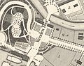
Krahe's draft plan has not survived, but the planning intentions become clear, for example, in the city map by Carl Wilhelm Schenk from around 1820.

Gate situation at the turning gate
The straight turning gate wall runs towards the Gaußberg
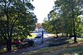
The semicircular system at the Wendentor

Semicircular system at the Augusttor and radial streets

Map of the city center with the Wallring 1899
.JPG)
.JPG)


.jpg)
Landmarks and topographical objects
|
Streets and Squares: |
|
Parks: |
Green areas:
|
Hill:
|

Island wall

Museum park


Buildings
The construction of the ramparts began in the early 19th century. While initially mostly gardens with garden houses were laid out on the Wallring, later development with villas followed. Construction activity peaked in the second half of the 19th century. In accordance with the architectural styles that were widespread at that time, most of the buildings were built in the classicist and historicist styles.
A special part of the wall redesign was the erection of gatehouses on the arteries of the city, which Krahe himself designed in the classicist style. Of these gatehouses, those on Wendentor, Fallersleber Strasse and Helmstedter Strasse have been preserved. Further gatehouses were located at Wilhelmitor, Augusttor and Petritor.
Important cultural institutions were built on the Wallring: from 1859 to 1861 the State Theater (Large House) , from 1883 to 1887 the Herzog Anton Ulrich Museum and from 1901 to 1906 the Municipal Museum (Haus am Löwenwall) .

Gauss monument

Villa Salve Hospes

State Theater


Still images
In addition to the obelisk on the Löwenwall, there are other statues on the Wallring such as the memorial to the mathematician Carl Friedrich Gauß (1777–1855) in front of the Gaußberg, a memorial to the poet Gotthold Ephraim Lessing (1729–1781) on Lessingplatz and at the theater park a memorial to the composer Franz Abt (1819–1885). The obelisk was erected in memory of the dukes Karl Wilhelm Ferdinand and Friedrich Wilhelm, who fell in the battle against France.
Cultural monuments
Gatehouses

Fallersleber Gate

Stone gate

Turning gate

.JPG)

Further
- old trainstation
- Villa Salve Hospes
- Villa Gerloff
- State Theater (Big House)
- Duke Anton Ulrich Museum
- Municipal Museum (Haus am Löwenwall)
literature
-
Reinhard Dorn : Peter Joseph Krahe. :
- Volume 1 years of study in Düsseldorf and Rome 1178-1786. Braunschweig 1969.
- Volume 2 Buildings and Projects in Düsseldorf, Koblenz, Hanover and Braunschweig 1787-1806. Braunschweig 1971.
- Volume 3 Buildings and Projects in the Kingdom of Westphalia and the Duchy of Braunschweig 1808-1837. Edited by Elisabeth Spitzbart. Deutscher Kunstverlag, Munich, Berlin, 1999.
- Herman Flesche : The builder Peter Joseph Krahe 1758–1840. Vieweg Verlag, Braunschweig 1957.
- Peter Giesau: Krahe, Peter Joseph. In: Luitgard Camerer , Manfred Garzmann , Wolf-Dieter Schuegraf (eds.): Braunschweiger Stadtlexikon . Joh. Heinr. Meyer Verlag, Braunschweig 1992, ISBN 3-926701-14-5 , p. 133-134 .
- Jürgen Hodemacher: Braunschweig's streets - their names and their stories. Volume 1: Inner City. Cremlingen 1995, ISBN 3-927060-11-9 .
- Jürgen Hodemacher: Braunschweig's streets - their names and their stories. Volume 2: Okergraben and city ring. Cremlingen 1996, ISBN 3-927060-12-7 .
- Wolfgang Kimpflinger: Monument topography Federal Republic of Germany. Architectural monuments in Lower Saxony. Volume 1.1 .: City of Braunschweig. Part 1, Hameln 1993, ISBN 3-87585-252-4 .
- Ulrich Knufinke, Simon Paulus (Ed.): Peter Joseph Krahe. Guide to classicism in Braunschweig and the surrounding area. Braunschweig 2008.
- Simon Paulus, Ulrich Knufinke: The Braunschweiger Wallring. Guide to the history and architecture of a cultural and historical monument. With photographs by Heinz Kudalla, Appelhans Verlag, Braunschweig 2011, ISBN 978-3-941737-59-4 .
- Gerd Spies (Ed.): The Braunschweiger Löwenwall. In: Braunschweiger Werkstücke (= publications from the Städtisches Museum. Series B, Volume 98). Braunschweig 1997, ISBN 3-927288-28-4 .
- Heinz-Joachim Tute, Marcus Köhler: Garden art in Braunschweig: from the princely gardens of the Baroque to the public park of the Wilhelminian era. In: Braunschweiger workpieces. Series A Volume 28 / the whole series Volume 76, Waisenhaus-Druckerei, Braunschweig 1989, ISBN 3-87884-037-3 .
- Hans-Joachim Tute: Wallring. In: Luitgard Camerer , Manfred Garzmann , Wolf-Dieter Schuegraf (eds.): Braunschweiger Stadtlexikon . Joh. Heinr. Meyer Verlag, Braunschweig 1992, ISBN 3-926701-14-5 , p. 241 .
Individual evidence
- ↑ Braunschweiger Wallring must become a world cultural heritage. In: Braunschweiger Zeitung of April 13, 2010.
- ↑ Friedrich Knoll : Braunschweig and surroundings: historical-topographical manual and guide through the monuments and art treasures of the city. 1881.