Bammelsburg

The Bammelsburg was a defense tower of the fortifications of the city of Braunschweig . They secured the city wall in the north of the city between the Neustadt and Wendentor, in the course of today's island wall .
history
| Bammelsburg in old maps
|
||
|---|---|---|
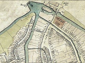
| The location of the Bammelsburg Bridge on a map of the city of Braunschweig from 1798.
|
||
| The Bammelsburg in a section of a bird's eye view from 1606, positioned on the later Rudolphs stronghold. | ||
The Bammelsburg was on a long island, bordered by a flood ditch on the outside of the city wall and another moat on its inner side facing the city, the so-called Bosselgraben .
The origin of the name is unclear. It is possible that " Bammel " ( Low German for fear , fear ) refers to a disgraceful bell that was rung when criminals were expelled , or that it means a fortress that makes enemies fearful.
In the 15th century the defense tower, like many other fortifications in the city, was rebuilt in order to adapt it to the changed technical requirements. During this time the crews of the Braunschweig defense towers and bergfrieds were equipped with firearms .
The Bammelsburg was at its base a semicircular tower, on which a square high tower with a slender top was attached. It was temporarily equipped with seven cannons.
With the use of heavy artillery, the tower lost its importance for the defense of the city. In the 18th century the tower was shortened and its upper floor was converted into a studio apartment , which was made available to ducal court painters . The court painter J. von Span set up a wallpaper factory here around 1760 and the landscape painter Pascha Johann Friedrich Weitsch (1723–1803) set up a drawing school for “educated classes” from 1771 . A drawing from the end of the 18th century shows a semicircular tower stump as the basement of a square half-timbered building with a hipped roof .
In 1830 or 1831 the building was demolished. The last remains of the wall, which still showed the building inscription " MCCCCLX " (1460), were removed in 1907. Today the Bammelsburger Strasse , located between Gaußberg and Gauß-Brücke , and the Bammelsburger Teich in Inselwallpark are still reminiscent of the city's former fortress.
literature
- Luitgard Camerer , Manfred Garzmann , Wolf-Dieter Schuegraf (eds.): Braunschweiger Stadtlexikon . Joh. Heinr. Meyer Verlag, Braunschweig 1992, ISBN 3-926701-14-5 , p. 28 .
- Andrea Boockmann (Ed.): The inscriptions of the city of Braunschweig until 1528 . Reichert, Wiesbaden 1993, ISBN 3-88226-513-2 .
- Hermann Dürre : History of the City of Braunschweig in the Middle Ages . Grüneberg, Braunschweig 1861 ( digitized version ).
- Carl Wilhelm Sack : The fortification of the city of Braunschweig . In: Archives of the Historical Association for Lower Saxony . Historical Association for Lower Saxony (Ed.), Verlag Hahnsche Hofbuchhandlung, Hanover 1847.
- Carl Wilhelm Sack: The fortification of the city of Braunschweig . In: Archives of the Historical Association for Lower Saxony . Historical Association for Lower Saxony (Ed.), Verlag Hahnsche Hofbuchhandlung, Hanover 1848.
Web links
Individual evidence
- ↑ a b c Sack (1847), p. 248 f.
- ^ Historical association for Lower Saxony (ed.): The fortification of the city of Braunschweig . In: Archives of the Historical Association for Lower Saxony . Hahnsche Hofbuchhandlung Verlag, Hanover 1850, p. 14.
- ↑ Martin Eberle, Justus Lange (Ed.): Braunschweiger Rokoko . Städtisches Museum, Braunschweig 2005, p. 106, ISBN 3-927288-37-3 .
- ^ Paul Zimmermann : Weitsch, Friedrich. In: Allgemeine Deutsche Biographie . Volume 41, Duncker & Humblot, Leipzig 1896, pp. 626-629.
- ↑ a b Boockmann
Coordinates: 52 ° 16 ′ 17.5 ″ N , 10 ° 31 ′ 19.2 ″ E


