
Echternstrasse (Braunschweig)
| Echternstrasse | |
|---|---|
|
|
|
.JPG) |
|
| View from Prinzenweg into Echternstraße in north direction. | |
| Basic data | |
| place | Braunschweig |
| District | Old town |
| Created | 13th Century |
| Hist. Names | platea finalis (1304), Echterenstrate (1310), Achternstrate (1465) |
| Connecting roads | to the north: Güldenstrasse ; to the south: Prinzenweg |
| Cross streets | to the west: Sonnenstrasse ; to the east: Sonnenstrasse |
| Buildings | Stobwasser House, St. Michaelis Church , Seniorenwohnstift Wohnpark am Wall |
| use | |
| User groups | Pedestrian traffic , bicycle traffic , car traffic |
The Echternstraße is a street in the city of Braunschweig . It is laid out in a north-south direction and runs parallel to Güldenstraße to the west , which it meets at the northern end. At its southern end, Echternstrasse meets Prinzenweg, which runs across it . The street, which was formerly characterized by half - timbered houses , lost its original character due to the destruction during the Second World War and subsequent redesigns in the part to the north of Sonnenstraße . The southern part of Echternstrasse was hardly affected by war damage, so that in the area of the “traditional island Michaeliskirche” a street scene typical of the “old” Braunschweig could be preserved.
history
The Echternstraße, which runs in the soft image of the old town , is designated as platea finalis in 1304, i.e. the last street before the city wall adjoining to the west. The name echterenstrate is documented for the year 1310 , which is derived from the Low German word achter for behind , ie directly behind the city fortifications. In 1940 there were still extensive remains of the city wall on land to the west of Echternstrasse. The spelling in 1465 was achternstrate , while the city maps 1606 Echternstras , 1671 die ächternstrasse , 1758 Aechternstrasse and 1798 the current spelling. The combined continuation of Echternstraße and Güldenstraße to Petritor was often counted as Güldenstraße, less often Echternstraße, for example houses No. 834 and 837 in the middle of the 15th century. At the northern end of Echternstraße, the Südklint began with its second Half-timbered buildings completely destroyed during World War II. In the 1960s, the Südklint had to give way to the expansion of Güldenstrasse. Poor strata of the population lived in Echternstrasse. The hangman's apartment and the prostitutes he supervised contributed to a somewhat dubious reputation of the street in the late Middle Ages. During the Second World War, most of the half-timbered buildings in the part north of Sonnenstrasse were destroyed. In the southern part of Echternstrasse, a large part of the buildings could be saved from destruction through the efforts of the local population and the fire brigade unit stationed in the school. The traditional island of St. Michaelis was renovated in the 1990s with funding from the federal government and the city. The street was paved with cobblestones instead of asphalt paving.
From July 1, 2003 to March 31, 2004, archaeological excavations were carried out on an area of 6000 m² on Echternstrasse. A previously unknown part of a medieval fortification and the foundation of a defense tower were discovered. In a medieval sewer, remains of fur and cloth, cherry stones, grain and various wooden vessels came to light. T. from the 13th century. Within the different layers of the earth, a layer of fire could be assigned to the documented great city fire of 1278.
Development
Historic buildings
St. Michaelis Church
The St. Michaelis Church , located between Echternstraße and Güldenstraße, was consecrated in 1157 and extended with side aisles at the beginning of the 13th century. The conversion to a three-aisled Gothic hall church took place between the 13th and 15th centuries. The ev.-luth. Parish church was extensively restored in 1879/1881 by Ludwig Winter and Max Osterloh . In contrast to its surroundings, the building survived the Second World War largely unscathed.
Stobwasser house
Georg Heinrich Stobwasser (1717–1776), who came from Lobenstein in Thuringia , moved to Braunschweig, where he and his father Georg Siegmund Eustachius Stobwasser founded a factory there in 1763 as a "paintwork factory" . Since 1771 this has been at Echternstraße 16 in the former Schmeichelburg (property no. 587 and 588), also called St. Michaelisburg , which is documented in 1669 as the Mr. Zehnmänner Hauss . Due to the high quality of Stobwasser's products and the resulting great demand from the Braunschweig court , court society, the military and the merchants, the new "factory" quickly developed into a large company for the time, employing almost a hundred people soon sold their products nationally and internationally. The Stobwasserhaus was not destroyed in World War II and is now used for social purposes. On June 18, 1815, a group around Christian Heinrich (Eustachius) Stobwasser founded the Braunschweig Bible Society here . On July 23, 1969, the house was given a showcase with mementos from the lacquerware manufacturer Johann Heinrich Stobwasser and the first German President Friedrich Ebert , who lived here for three months in 1890.
Red monastery
At the southern end of Echternstrasse, the so-called Red Monastery has been located since the 14th century , and in 1402 it was documented as the rode monastery . In house no. 575 already lived 1402 de hengher , i.e. the executioner who supervised the prostitutes working in the four public houses no. 576 to 579 .
Preacher widow house
Since 1559, the St. Martini Prediger widow's house stood at Echternstrasse 14 (house no. 585 and 586) , which was still owned by the Martinikirche in the 18th century. For the new building of the rectory of St. Michaelis, the southern part of the three-storey eaves half-timbered house was demolished in 1899. A third of the inscription on the sill beam of the protruding second floor was destroyed. The surviving Latin and German text is interrupted by a picture of the Brunswick lion:
- [VRBS · EVANGELII · QVIBVS · EST · VETVSTAS. MINISTRIS
- HIC · HABBIT (ANT) · VIDVAE ·] POST · PIA · FATA · VIRVM ·
- dwelling · the · letting · widwen · the · dead · preacher ·
- in the old city through a conceivable wad of wheels vnd
- filer erbar fromen christe (n) promotion erbawet an (n) od (o) m (in) i 1559
The translation of the Latin text, the part of which in square brackets is no longer preserved, reads: “The city for the ministers of the Gospel who have reached an old age. This is where the widows live after the pious death of (their) husbands. "
More buildings
The Ratsmarstall and the sheepfold of the old town and the Sack were located in Echternstrasse . The Michaelis sacrifice, dat opperhus , was moved from No. 571 to No. 574 in 1459. The houses No. 581 and 582 are referred to in 1534 as the knokenhawer hus and in the 18th century as the bone carving guild house and sheepfold . In 1512, the nationally known bell and gun founder Hinrik Mente bought a large piece of land on Echternstrasse. The location directly on the city wall reduced the risk of fire from the workshop. Mente made bronze bells and baptismal fonts for the parishes of the city and the surrounding area. At the end of the 18th century, the space behind the courtyards of Echternstrasse between the city wall and the moat was turned into a later dilapidated promenade, which Philip Christian Ribbentrop called "philosophical walk" in 1789 and "Promenade am Mauergraben" in the city map from 1798.
Today's development
Seniorenwohnstift Wohnpark am Wall
The Seniorenwohnstift Wohnpark am Wall with 171 apartments is located at Echternstraße 46-49 . It was opened on August 28, 1987 after almost two years of construction. On September 21, 1989, an information visit was made by the Luxembourg Minister for Health, John Lakure.
schools
On June 28 and 29, 1974, the 100th anniversary of the elementary school at Echternstrasse 1–3 was celebrated. As a result of the school structure reform in Lower Saxony in 2004, a second school location was set up at Echternstrasse 1 for the 5th and 6th grades of the Martino-Katharineum grammar school (small MK).
More buildings
On December 2, 1968, the new administration building of the Guild Health Insurance Fund, Echternstrasse 31-32, was inaugurated. To the north of St. Michaelis Church is the Michaelishof building complex, which was built in 1983 as a half-timbered building and is used as a student residence. According to the postal address, however, it belongs to Güldenstrasse.
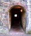
Impressions

Michaeliskirche seen from Echternstrasse to the west

West side of Echternstrasse. The last two houses in the row belonged to the Stobwasser manufactory .
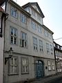
Stobwasser house

Remains of the historic city wall from the 15th century on Neustadtmühlengraben near Echternstraße / Gieselerwall
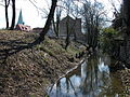
The Neustadtmühlengraben between Echternstraße (left) and Wilhelmitorwall (right) looking south. On the left in the background the tower of the Michaeliskirche is visible.
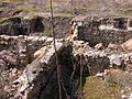
Cellars unearthed during archaeological excavations on Echternstrasse
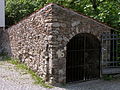
Medieval battlement
View from the side of the Neustadtmühlengraben on the battlements through the historic Braunschweig city wall.

Echternstrasse 34 in 1894.
.JPG)
.JPG)
.JPG)

.JPG)
.JPG)
.JPG)

.JPG&filetimestamp=20120411191953&)
literature
- Johannes Angel: Echternstrasse . In: Luitgard Camerer, Manfred RW Garzmann and Wolf-Dieter Schuegraf (eds.): Braunschweiger Stadtlexikon , Braunschweig 1992, ISBN 3-926701-14-5 .
- Jürgen Hodemacher : Braunschweigs streets - their names and their stories, Volume 1: Innenstadt , Cremlingen 1995, ISBN 3-927060-11-9 .
- Wolfgang Kimpflinger: Monument topography Federal Republic of Germany , architectural monuments in Lower Saxony, Volume 1.1 .: City of Braunschweig, Part 1. Hameln 1993, ISBN 3-87585-252-4 .
- Heinrich Meier : The street names of the city of Braunschweig. In: Sources and research on Brunswick history. Volume 1, Wolfenbüttel 1904
Web links
Individual evidence
- ^ Norman-Mathias Pingel: City wall . In: Braunschweiger Stadtlexikon , Braunschweig 1992, pp. 217f.
- ↑ Dieter Heitefuß: Braunschweig von oben , Braunschweig 1999, p. 26.
- ↑ Dirk Rieger: platea finalis: Research on Braunschweig's Old Town in the Middle Ages , Contributions to Archeology in Lower Saxony, Volume 15, Verlag Marie Leidorf GmbH, Rahden / Westf., 2010, p. 23.
- ^ Loud traces of the Middle Ages , Braunschweiger Zeitung , July 29, 2003
- ↑ Medieval defense tower discovered , Braunschweiger Zeitung , September 18, 2003
- ^ The seat of the outhouse fell into the sewer , Braunschweiger Zeitung , December 2, 2003
- ^ Emil Ferdinand Vogel : Antiquities of the City and the State of Braunschweig , Braunschweig 1841, p. 49.
- ↑ Friedrich Knoll : Braunschweig and surroundings: historical-topographical manual and guide through the monuments and art treasures of the city. Braunschweig 1881, p. 135.
- ^ Sabine Wehking : DI 56, No. 483, in: Deutsche Insschriften Online
- ↑ Sabine Wehking, DI 56, No. 483, in: Deutsche Insschriften Online
- ^ Description of Michaelishof , accessed on June 10, 2012
Coordinates: 52 ° 15 ′ 39 " N , 10 ° 30 ′ 50.7" E