
Ottilient part
.JPG)

.JPG)

Ottilienteil , in earlier spelling also Othilientheil , was once the name of a small square in the Aegidienviertel in Braunschweig's city center, the history of which goes back to the Middle Ages. At the time of its creation, it was once quite isolated due to its location on the edge of the aegidia freedom and directly on the Oker, but today it is accessible from at least three sides thanks to a connection to the Rosenhagen. Today this street space is assigned to Aegidienstraße , the street name Ottilienteil has been deleted.
In the Middle Ages, the bailiff of the Aegidienkloster held a public court three times a year against the monastery servants.
location
The Ottilien part was originally part of a special rights district within the city of Braunschweig, which surrounded the Aegidienkirche and was called " Aegidien Freiheit " or "Klosterfreedom". He was within the Altewiek soft area . This "freedom" was legally independent and therefore independent of the city.
The Oker , which is now canalized in the Braunschweig city center, flowed through the city in numerous branches and branches of water until the 20th century, thus forming a break with headlands in some places . The Ottilienteil was located at such a point around which the Oker flows, at the Aegidienmühle, today Aegidienstraße (which was called Mühlenstraße until 1861) and was only accessible via a bridge. The western Okerarm was channeled underground before 1907, the eastern one after 1945. Aegidienstrasse widens like a square from east to west and forms a triangle. This space, which was mainly surrounded by small half-timbered houses, is limited in the west by the building of the general consumer association erected there in 1907 .
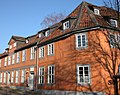
The narrow, in places overlapping buildings with small, unadorned half-timbered houses suggests that the Ottilien part was the residential area of poor sections of the population in earlier times.
designation
The meaning and origin of the names Ottilienteil and Othilientheil are unclear and controversial. Since it belonged to the special legal district of the monastery, no municipal documents exist about the dwellings there from the early period. Only in 1604 are five houses mentioned that were in the "Zilkendey" due to construction work . In 1758 this name can be found in the city map, followed in 1789 by "Tielkendey" . It was not until 1813 that “Ottilientheil” appeared for the first time . In 1822, however, again “Zilkendey or Ottilientheil” . In 1789 Philip Christian Ribbentrop derived the name from the name "Sunte Ylien" - for "Sankt Aegidien" - documented in 1320 . “ Thie ” for court was also given as a possible origin. Richard Andree has attempted to show in 1900 that "Zilkendei" or "Silkendei" the importance sulking had. He had also borne the name Sunte Ylien tey .
Closer historical urban environment
Birthplace of the musician Louis Spohr

The Altewiekrathaus (demolished in 1752)

The house where Gotthold Ephraim Lessing died (photo around 1905, the house was destroyed in the Second World War)
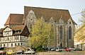
Aegidienkirche (northern view, in front of it on the left the Leisewitz-Haus, which has been moved here from Wallstrasse )

Part of the former monastery (has housed part of the state museum since 1902 )

Ruins of the Hotel Handelshof on Lessingplatz (destroyed in World War II)
.JPG)
.JPG)


_(1).jpg)


.JPG)
literature
- Camerer, Garzmann, Schuegraf, Pingel: Braunschweiger Stadtlexikon. Meyer, Braunschweig 1992, ISBN 3-926701-14-5 .
- Jürgen Hodemacher : Braunschweig's streets - their names and their stories, Volume 1: Downtown. Elm-Verlag, Cremlingen 1995, ISBN 3-927060-11-9 .
- Heinrich Meier : The street names of the city of Braunschweig. In: Sources and research on Brunswick history. Volume 1, Wolfenbüttel 1904, ( digitized version )
Individual evidence
- ↑ Jürgen Hodemacher: Braunschweigs streets - their names and their stories, Volume 1: Innenstadt. P. 13.
- ↑ Braunschweig and the surrounding area: Historical-topographical handbook and guide through the monuments and art treasures of the city by Fr. Knoll , 1881
- ↑ Städtisches Museum Braunschweig (Ed.): The exhibition 'History of the City of Braunschweig' in the old town hall. Part 1, p. 91.
- ^ Heinrich Meier: The street names of the city of Braunschweig. Wolfenbüttel 1904, p. 12.
- ↑ Wolfgang Kimpflinger: Monument topography Federal Republic of Germany. Architectural monuments in Lower Saxony. Volume 1.1 .: City of Braunschweig. Part 1, Hameln 1993, p. 136.
- ^ Heinrich Meier: The street names of the city of Braunschweig. Wolfenbüttel 1904, p. 80.
- ^ Richard Andree : Braunschweiger Volkskunde. 2nd edition, Braunschweig 1901, p. 128.
Web links
- Plan of the Aegidien quarter on braunschweig.de
- Othilienteil on braunschweig.de
Coordinates: 52 ° 15 ′ 37.3 ″ N , 10 ° 31 ′ 27.3 ″ E