
Ackerstrasse
| Ackerstrasse | |
|---|---|
|
|
|
 |
|
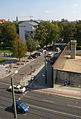
| Pappelplatz on Ackerstrasse | |
| Basic data | |
| place | Berlin |
| District |
Mitte , Gesundbrunnen |
| Created | in the middle of the 18th century |
| Hist. Names |
Second row in the New Voigtland (around 1752–1801) , third row in the New Voigtland (around 1752–1801) |
| Connecting roads |
Gartenstrasse (northwest) , Große Hamburger Strasse (southeast) |
| Cross streets |
(Selection) Feldstrasse, Bernauer Strasse , Invalidenstrasse , Torstrasse |
| Places | Garden square, poplar square , Koppenplatz |
| use | |
| User groups | Pedestrian traffic , bicycle traffic , car traffic |
| Technical specifications | |
| Street length | 1800 meters |
The Ackerstraße is a 1.8 kilometer road in Berlin's Mitte district , which the district center to the district Gesundbrunnen runs and in the historical district Oranienburger suburb located.
Location and course
Ackerstraße begins on Linienstraße in the district of Mitte, runs north to Invalidenstraße , bends to the northwest and then goes to Scheringstraße in the district of Gesundbrunnen. The house numbers run in horseshoe form from house no.1 at the corner of Linienstraße to Scheringstraße and back to house no.174.
Naming
The Ackerstraße got its name after the fields of the Berlin Feldmark, which was opened up with it. The street that was laid out around 1750 was called the second row in the New Voigtland and the third row in the New Voigtland until 1801 .
history
18. – 19. century
The then city commandant Lieutenant General Graf von Hacke had received an order from the Prussian King Friedrich II on September 22, 1751 to have residential houses built on an area in front of the Berlin city wall between the Hamburger Tor and the Rosenthaler Tor . Initially, 30 houses for 60 families were planned, selected from a group of applicants of settlers . The basic idea of Friedrich II. Was the settlement of qualified specialists from non-Prussian German areas in his domain. The new residents were mostly craftsmen and came from Voigtland , which is why the newly created settlement area was named New Voigtland . The streets were laid out in parallel lines and labeled accordingly - today's Ackerstraße was initially the second row in the New Voigtland . All houses in the Neu-Voigtland colony were type buildings because of the fast and inexpensive production, which set a new trend. Gardens were laid out between the individual buildings. When more residents were added in the 19th century due to urban densification and social restructuring, new streets were built and these were counted anew - now Ackerstraße was the third row in the New Voigtland . In the 19th century, the term “Voigtland” became a synonym for poverty and anti-sociality in Berlin . The area was derisively called "Berlin Sahara". The existing houses were now often extended by side extensions until they finally became closed street fronts. Later on, cafés and beer taverns set up shop here, and even a brewery (“Bergschlößchen”) in the neighboring Bergstrasse.
The area was no longer called the Neu-Voigtland colony, but Oranienburger Vorstadt . In August 1800, their residents wrote a letter to the police directorate to apply for official street names to be assigned. At the suggestion of a police officer, the third row in the New Voigtland was named Ackerstraße on February 18, 1801. (Neighboring streets were called Bergstrasse and Gartenstrasse from the same time.) On April 6, 1833, the next section of road, between Invalidenstrasse and Liesenstrasse, was incorporated into Ackerstrasse and initially called Neue Ackerstrasse . The southern extension of the street to Koppenplatz took place in 1877. However, the residents there wanted their own name for their route, it should be called Virchowstraße . However, this request was not granted.
In 1844, roughly in the middle of Ackerstrasse (No. 37), the St. Elisabeth cemetery was laid out and is still in use today.
In the 1870s and 1880s, the street was given a completely new look with new rental houses and the population of the area increased enormously. In 1895 the first subway in continental Europe was built here. It connected the AEG equipment factory in Ackerstrasse with the AEG factory premises in Voltastrasse. At the end of the 19th century, the Ackerhalle was built on the corner of Invalidenstrasse , which has been preserved to this day.
Since the 20th century
Between 1961 and 1989, when the Berlin Wall divided the city, part of Ackerstrasse was in the border strip and could only be entered with special permission. In 1982, in the section between today's Torstrasse and Invalidenstrasse, 29 houses were placed under monument protection as the Ackerstrasse ensemble . From 1994 to 2009 the southern part of Ackerstraße in the Mitte district was part of the Rosenthaler Vorstadt redevelopment area.

Schwindsuchtbrücke over Ackerstraße, painting by Gustav Wunderwald

Meyers Hof at Ackerstraße 132-133, around 1910

Colonist house Ackerstraße 94
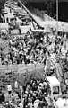
Demolition of the wall at the corner of Bernauer and Ackerstraße, 1990
Section of Ackerstrasse as part of the Berlin Wall Memorial , 2011


.JPG)


Buildings and Memories
→ List of cultural monuments in Berlin-Mitte / Oranienburger Vorstadt
- The first section of the New Berlin Horse Railway from Alexanderplatz to Gartenstraße also ran through the northern Ackerstraße, in the southern section of which, however, in house no. 4 there was a depot of the Great Berlin Horse Railway (GBPfE).
- The blacksmith's workshop was located on Ackerstrasse, where Puhl & Wagner attempted melting of their glass mosaics.
- From 1990 the songwriter Rainald Grebe lived at Ackerstrasse 5 .
- Ackerhöfe: Ackerstraße 14/15.
- The mechanical engineering entrepreneur Wilhelm Carl Johann Wedding had his business office at Ackerstrasse No. 50 and No. 76.
- Opposite house number 76 is the Catholic Church of St. Sebastian on the adjacent garden square .
- Ackerstraße 80 is one of the few remaining tenements with square buildings, a closed inner courtyard and all-round accessible roof structure.
- The ( Buddhist ) Fo Guang Shan temple is located at Ackerstraße 85/86 in the area of the Gesundbrunnen district .
- The Meyers Hof tenement was located at Ackerstrasse 132 .
- From 1867 the Berliner Maschinenbau AG (BMAG - from 1870) produced on Ackerstraße (/ Feldstraße).
- A total of 19 historical buildings have been preserved in Ackerstrasse (house numbers 1–5, 10–13, 16/17, 19–22, 144–147, 154/155, 165, 171) and are listed buildings .

Monument ensemble Ackerstraße
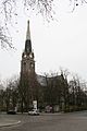
St. Sebastian Church

Former AEG -Apparatewerk, Acker- corner Feldstrasse

Alternative culture house chocolates

Residential and commercial building, completed in 2016


Literary setting
- The Ackerstraße is the main location of the trilogy of turning points by Klaus Kordon , consisting of the volumes Die Roten Sailor (A forgotten winter) , With the back to the wall and The first spring . The Gebhardt family, which is the focus of all volumes, lives at Ackerstraße 37, but according to the author in the epilogue of the first volume there is actually a cemetery on that street at number 37. In the foreword of the first volume, Kordon characterizes Wedding as the poorest part of Berlin and Ackerstraße as the poorest street in Wedding.
- The novel The Girl from Ackerstrasse. A moral picture from Greater Berlin (1920) by Ernst Friedrich ( pseudonym of Hermann Fleischack) and its sequels were also filmed in several parts.
- Roman Ackerstraße - A Berlin Tragedy , Bernd Kaufmann Fischer Verlag Frankfurt / Main 2008 ISBN 978-3-89950-335-7 , or the same content The Director - A Berlin Tragedy , Bernd Kaufmann BKP Verlag 2011 ISBN 978-3-9813424-1- 3 .
See also
- List of streets and squares in Berlin-Mitte
- List of streets and squares in Berlin-Gesundbrunnen
- Berlin-Milieu: Ackerstraße 1973 , documentary of the State Film Documentation at the State Film Archive of the GDR by Veronika Otten from 1973.
Web links
- Ackerstrasse. In: Street name lexicon of the Luisenstädtischer Bildungsverein (near Kaupert )
- District management area - center: Ackerstraße
Individual evidence
- ↑ a b c Laurenz Demps : Ackerstraße - back then in the Sahara. From: Historical Berlin Lexicon . In: BZ am Abend , October 9, 1982
- ↑ Ackerstrasse. In: Street name lexicon of the Luisenstädtischer Bildungsverein (near Kaupert )
- ^ Berlin Street: The AEG.
- ^ Kulturbund der DDR (Ed.): For the publication of the monument lists of the city districts of Köpenick, Mitte and Prenzlauer Berg, Berlin 1982.
- ↑ Ackerhöfe ( memento of November 23, 2007 in the Internet Archive ) at the Senate Department for Urban Development
- ↑ Architectural monuments Ackerstraße
Coordinates: 52 ° 32 '7.4 " N , 13 ° 23'25.1" E