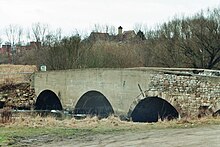
Saale-Elster-Aue


Saale-Elster-Aue describes the meadow landscape in the area of the confluence of the Weißer Elster and Luppe into the Saale . It is located between the cities of Halle (Saale) and Merseburg and includes the FFH area “Saale-, Elster-, Luppe-Aue between Merseburg and Halle” with a size of 1756 hectares and the nature reserve “ Saale-Elster-Aue near Halle” “With a size of 915 hectares. The drinking water protection area of the city of Halle is located in the Saale-Elster-Aue .
geology
Geomorphologically the Saale-Elster-Aue is a salt leaching lowland. Its formation was mainly due to the last terminal moraine in the region ( Tauchaer terminal moraine ) in the Saale glaciation (Drenthe stage). This diverted the White Elster in the area of what is today Leipzig to the west towards the Saale and also enabled the Leipzig water junction and the Elster-Luppe-Aue to develop.
Due to its low gradient and its high sediment load, the White Elster (often referred to as the inland delta ) anastomoses and tributaries such as the Luppe, Gerwische or the marrow ditch and numerous oxbow lakes have formed in its kilometer-wide floodplain . Other bodies of water that are part of the floodplain today include the Saale and its oxbow lakes, the Wallendorfer See and Raßnitzer See lakes . The latter are former lignite opencast mines.
The floodplain is still largely subject to natural water level dynamics with regular spring and rare autumn / winter floods. The area is strongly influenced by the backwater of the White Elster and the simultaneous flooding of the Saale.
flora
The landscape extends from softwood and hardwood areas, foxtail meadows , reed grass meadows to extensive, sometimes inaccessible wetlands. Field elm , hawthorn , sloe and elderberry bushes are important plants in the meadow landscape .
fauna
Birds that use the floodplain include the little grebes , great bitterns , spoonbills and tufted ducks , water rail , partridge , great gray shrike , white and black storks . The largest gray heron breeding area in Europe was in the floodplain, and the presence of raccoons is endangered. Leaf crabs live in the aquatic environment .
Localities
Immediately in the floodplain are u. a. the districts of Planena , Burg and Röpzig , which are often completely enclosed during floods.
traffic
The new Erfurt – Leipzig / Halle line , the old Thuringian Railway line and parallel federal highway 91 (with the Halle-Bad Dürrenberg tram line ) cross the floodplain.
The Saale-Elster valley bridge, the longest railway bridge in Europe, visually dominates the floodplain.
Individual evidence
- ↑ FFH compatibility test for the area DE 4537 301 "Saale-, Elster-, Luppe-Aue between Merseburg and Halle" ( Memento of the original from October 1, 2015 in the Internet Archive ) Info: The archive link was automatically inserted and not yet checked. Please check the original and archive link according to the instructions and then remove this notice. State Office for Flood Protection and Water Management of the State of Saxony-Anhalt, On: lvwa.sachsen-anhalt.de (PDF, German, 2.78 MB)
- ↑ Description of the NSG0173 ( Memento of the original from April 8, 2010 in the Internet Archive ) Info: The archive link has been inserted automatically and has not yet been checked. Please check the original and archive link according to the instructions and then remove this notice. State administration office of Saxony-Anhalt, at: lvwa-natur.sachsen-anhalt.de
- ^ Friedrich / Frühauf, Halle and its surrounding area, mdv-Verlag, Halle, 2002, ISBN 3-89812-167-4
- ↑ Management plan for FFH 141 "Saale-, Elster-, Luppe-Aue between Merseburg and Halle" On: sachsen-anhalt.de, State Office for Environmental Protection Saxony-Anhalt, Halle (Saale) 2011 (pdf; 5.9 MB)
literature
- Walter Müller (Ed.): The Liebenau . Verlag Druckwerk Halle, Halle (Saale) 2008.
Coordinates: 51 ° 24 ′ 0 ″ N , 12 ° 0 ′ 0 ″ E

