Luppe (river)
| Doll | ||
|
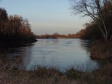
Luppe between Wegwitz and Zöschen |
||
| Data | ||
| Water code | EN : 5658 | |
| location | Saxony-Anhalt | |
| River system | Elbe | |
| Drain over | Saale → Elbe → North Sea | |
| source | as a branch of the Neue Luppe at Kleinliebenau 51 ° 22 ′ 45 ″ N , 12 ° 12 ′ 23 ″ E |
|
| muzzle | near Schkopau in the Saale Coordinates: 51 ° 23 '26 " N , 11 ° 59' 43" E 51 ° 23 '26 " N , 11 ° 59' 43" E
|
|
| length | about 25 km | |
| Drain |
MQ |
54 l / s |
| Left tributaries | Dig up , brook | |
| Small towns | Schkopau | |
The Luppe is a right tributary of the Saale . Until the Neue Luppe was built in the 1930s, it was the largest tributary of the White Elster in its anastomosing lower course (often referred to as the inland delta ) and branched off from it in the Leipzig water junction. Together they regularly flooded the Elster-Luppe-Aue, a large alluvial forest between Leipzig and Halle .
Demarcation
With the construction of the New Luppe, the former Luppe was divided into several remaining parts together with its numerous side arms. Luppe still refers to the former lower course, the 25 km long section that flows into the Saale. The other sections flow into the Neue Luppe today ( Kleine Luppe , Nahle or Alte Luppe ), are outflow-free oxbow lakes (Sixtholzluppe) or have been filled, like the section between the Nahle in the area of Gustav-Esche-Straße and the Alte Luppe near the Alfred Kunze Sports Park in Leutzsch , which still forms the border between Leutzsch and Wahren today. The Rote Luppe, the Heuwegluppe, the Nameless Luppe, the Northern Old Luppe and the Moorluppe are former tributaries north of the Old Luppe.
The Rote Luppe branched off to the right of the Luppe east of Gundorf and merged into the same north of Gundorf. Shortly before the mouth of the Rote Luppe, the Heuwegluppe also branched off to the right from the Rote Luppe. After the mouth of the Rote Luppe, first the Nameless Luppe and then the Northern Old Luppe branched off the Luppe on the right. The Heuwegluppe and the Nameless Luppe merged north of today's mouth of the Alte Luppe with the northern Old Luppe, which flowed back into the Luppe at Maßlau .The section on the right side of the Neue Luppe, called Sixtholzluppe, is the extension of the Alte Luppe and today a still water without drainage. The Moorluppe had its origin between Zweimen and Zöschen and ended between Lössen and Burgliebenau in the Markgraben, also a former branch of the Luppe.
Today's course


The Luppe branches off from the Neue Luppe north of Kleinliebenau , but is not fed by it and is therefore a stagnant body of water in this area. It crosses a flood polder near Kleinliebenau, continues through Horburg-Maßlau and then takes the Augraben on the left at Dölkau , which is a former tributary of the Zschampert . In the further course, the Luppe passes Zweimen, Zöschen, Wegwitz and Wallendorf , where the Lützen branch of the Elsterfloßgraben flowed to it from the left until it was closed. The Luppe then flows through Tragarth and Löpitz, where it also takes up the brook on the left side . After flowing past Lössen shortly afterwards, it unites with the Alte Saale, whose bed it uses up to its confluence with the Saale near Schkopau.
Human interventions
In the years 1936 to 1938, sections of the Luppe ( Neue Luppe ) and the White Elster were relocated, straightened and diked in the Leipzig area . This measure for the faster discharge of the floods prevented the flooding of large areas of the Leipzig floodplain forest , but also promoted the progressive drying out of the natural wetlands and thus led to the endangerment of the flora and fauna adapted to the special habitat.
Web links
- Restoration of the former watercourses of the Luppe , part II, bgmr landscape architects, 2009 ( PDF file; 9.7 MB )
- Nature Conservation Today - Issue 3/00 ( Memento from June 15, 2009 in the Internet Archive )
- Description with card
Individual evidence
- ↑ a b c Restoration of the former watercourses of the Luppe. (Section 2.1.2.1 Luppewildbett), Part 1, bgmr Landschaftsarchitekten, 2006, p. 18 ( PDF file; 13.7 MB )
- ↑ (New Luppe subsequently drawn in), excerpt from sheet 10 (from 1907), Topographical Map Saxony 1: 25000 (measuring table sheets), department for land survey of the Königl. Saxon. General Staff, Leipzig, on: deutschefotothek.de
- ↑ Meilenblätter von Sachsen 1: 12000 "Berliner Exemplar", recorded 1780–1806 under the direction of Friedrich Ludwig Aster, box M 14433, sheets B7, B8, B13, on: deutschefotothek.de


