Zschampert
| Zschampert | ||
|
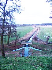
Zschampert near Rückmarsdorf |
||
| Data | ||
| location | Leipzig , Saxony , Germany | |
| River system | Elbe | |
| Drain over | Alte Luppe → Neue Luppe → White Elster → Saale → Elbe → North Sea | |
| source |
Kulkwitzer See 51 ° 18 ′ 37 ″ N , 12 ° 15 ′ 17 ″ E |
|
| muzzle | in the Domholz ( Leipziger Auenwald ) in the Alte Luppe Coordinates: 51 ° 22 ′ 20 ″ N , 12 ° 14 ′ 35 ″ E 51 ° 22 ′ 20 ″ N , 12 ° 14 ′ 35 ″ E
|
|
| length | 11 km | |
| Catchment area | 40 km² | |
| Drain |
MQ |
180 l / s |
The Zschampert stream is a tributary to the left of the White Elster . It flows through the Leipzig district of Miltitz and today receives its water mainly from Lake Kulkwitz , as its upper course between Seebenisch and Knautnaundorf has dried up.
From Miltitz the Zschampert flows past Lindennaundorf and Rückmarsdorf and forms the city limits between Leipzig and Markranstädt or Leipzig and Schkeuditz over long stretches . Between Rückmarsdorf and Burghausen, it passes under the Elster-Saale Canal in a 100 m long tunnel seven meters below the water level and flows into the Alte Luppe in Domholz ( Leipzig floodplain forest ) .
Before being straightened and shortened, the Zschampert flowed further west, parallel to the Luppe, and flowed into the same at Kleinliebenau . His remaining oxbow lake has largely dried up today, as is often the case with the Zschampert itself during the summer months.
The Augraben flowing west of Kleinliebenau is also a former tributary of the Zschampert. He is still known today as Zschampert. The common name Augraben has been recorded since 1940. The excavation is now fed by the drainage ditches west of the new Zschampert and flows into the Luppe at Dölkau, a district of Leuna near Zweimen .
Until the 1990s, the Zschampert was more like a sewer than a river, especially in Miltitz. The main causes were sewage from a chemical plant and the nearby residential areas.
swell
- Miles & measurement table sheets & equidistant map of Saxony (1780–1942) on: deutschefotothek.de
- The Zschampert in the Leipzig Lexicon
Individual evidence
- ↑ a b c restoration of former watercourses of the Luppe part 2, bgmr Landschaftsarchitekten 2009 (pdf)
- ↑ 51 ° 22 ′ 45 ″ N , 12 ° 12 ′ 22 ″ E
- ↑ Meilenblätter von Sachsen 1: 12000 “Berliner Exemplar”, recorded 1780–1806 under the direction of Friedrich Ludwig Aster, box M 14433, sheets B7, B8, B13, on: deutschefotothek.de
- ↑ Description of the NSG0197 ( Memento from March 4, 2016 in the Internet Archive ) Landesverwaltungsamt Sachsen-Anhalt, Auf: lvwa-natur.sachsen-anhalt.de
- ↑ Map of the NSG0197 ( memento from December 23, 2015 in the Internet Archive ) (PDF; 198 kB) Saxony-Anhalt State Administration Office, at: lvwa-natur.sachsen-anhalt.de
- ↑ Topographic map of Saxony 1: 25000 (measuring table sheets), department for land survey of the Königl. Saxon. General Staff, Leipzig, sheet 10 (1940), on: deutschefotothek.de


