Cathedral moat
|
Domgraben also Thumgraben, Connewitzer Graben |
||
|
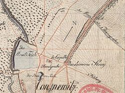
The course of the cathedral ditch in its lower part around 1800 |
||
| Data | ||
| location | Germany , Saxony | |
| River system | Elbe | |
| Drain over | Pleiße → Weisse Elster → Saale → Elbe → North Sea | |
| source |
Marienquelle 51 ° 18 ′ 46 ″ N , 12 ° 24 ′ 18 ″ E |
|
| Source height | 140 m | |
| muzzle | at Connewitz over the Streitteich to the Pleiße Coordinates: 51 ° 18 '32 " N , 12 ° 22' 5" E 51 ° 18 '32 " N , 12 ° 22' 5" E |
|
| Mouth height | 109 m | |
| Height difference | 31 m | |
| Bottom slope | about 7.8 ‰ | |
| length | about 4 km | |
| Big cities | Leipzig | |
The Domgraben (also Thumgraben or Connewitzer Graben) was a brook between the old town of Leipzig and the village of Connewitz to the south , a district of Leipzig since 1891.
The Domgraben was the northernmost of the former four right tributaries of the Pleiße and Mühlpleiße in what is now the southern urban area of Leipzig. The others were the Trenkengraben , the Loessniger Mühlgraben and the Leinegraben .
The Domgraben was the outflow of the Marienquelle , which was located southeast of the old Leipzig on Thonberger Flur and whose source is still in the Wilhelm-Külz-Park (formerly Amselpark) near the Völkerschlachtdenkmal . From here the ditch turned northwest to the old Funkenburg , an estate that existed here from the end of the 15th to the beginning of the 17th century before it was relocated to the city. At the old Funkenburg, whose corridor included the Marienquelle, the cathedral moat was dammed up to form two ponds. From here it flowed to the west, roughly along today's Richard-Lehmann-Straße, until it turned south shortly before the Connewitzer Holz and ran into the meadows of the floodplain or into the Connewitzer Streitteich (near today's Teichstraße), what cannot be found in the map material. The pond had a drain to the Pleiße.
In 1501, the City Council of Leipzig bought half of the water rights from the owner of the Funkenburg and brought half of the water from the cathedral ditch into the city as drinking water for the better-off Leipzig residents. This wooden water pipe fell into disrepair during the Thirty Years War .
At the end of the 19th century, the Marienbrunnen dried up because the hydrogeological structure was disturbed by cuts in the terrain during the construction of the railway, sand pits and other construction measures. The trench was backfilled, especially when building the Kaiserin-Augusta-Straße (Richard-Lehmann-Straße). Today only a deeper undeveloped area at the southeast corner of the Richard-Lehmann- / Windscheidstraße junction reminds of the former course of the cathedral ditch and after heavy rain the regular flooding of allotment gardens in the former course of the stream on Richard-Lehmann-Straße.
Individual evidence
- ↑ Christian Scholz: On the situation of the waters in the catchment area of the Mühlpleiße . In: Pro Leipzig (Hrsg.): Im Leipziger Pleißeland , Passage-Verlag 1996, ISBN 3-9804313-4-7 , p. 178
- ↑ Claus Uhlrich: The Marienborn and other stories from old Leipzig , PRO LEIPZIG 2001, ISBN 3-9807201-8-7 , p. 9
- ↑ Horst Riedel: Stadtlexikon Leipzig from A to Z. PRO LEIPZIG, Leipzig 2005, ISBN 3-936508-03-8 , p. 380
literature
- Connewitz - A historical and urban study . PRO LEIPZIG 2008
- Miles sheets from Saxony, Freiberg copy , recorded 1780–1806, sheets 18, 19 and 28, in the holdings of the Dresden Photo Library

