
Wilhelm-Külz-Park

The Wilhelm-Külz-Park is a park in the southeast of Leipzig near the Völkerschlachtdenkmal . It is named after the liberal politician Wilhelm Külz (1875–1948).
Location and shape
The Wilhelm-Külz-Park is located between the Old Exhibition Grounds and the Monument to the Battle of the Nations in the south-east part of the city on Thonberger Flur (main part of parcel 157/1), but administratively belongs to the Probstheida district . Its distance to Leipzig city center is three kilometers and its area is 22 hectares .
_01_ies.jpg)
The park is roughly triangular in shape. It is bounded in the northwest by the tracks of the Leipzig Hbf – Leipzig-Connewitz railway , in the northeast by Prager Strasse and in the south by the Völkerschlachtdenkmal, the southern cemetery and Richard-Lehmann-Strasse . It is crossed by Straße des 18. Oktober , Richard-Lehmann-Straße, Friedhofsweg and Straße An der Tabaksmühle, which divide the park into four areas. The Wilhelm-Külz-Park can be reached with the tram lines 2 and 15, the bus line 70 and the S-Bahn lines S1 and S4.
Curved park paths open up the entire complex of meadows and groups of trees. The park also contains some historically interesting objects (see below).
history
In 1898 the foundation stone for the Monument to the Battle of the Nations was laid. In order to create an attractive environment for the monument, work began on building a park north of the monument construction site in 1905. The planning came from the Leipzig gardening director Carl Hampel (1849–1930). Meadows were laid out and groups of trees were planted. The section of Straße des 18 Oktober, which leads through the park, has also been laid out in front of its northern parts. The park was named Monument Park . The name Amselpark spread among the population .

In 1913 the northern part of the park was included in the 1913 International Building Exhibition . This piece housed the so-called model village and the large amusement park of the exhibition with a water slide and dance palace.
In 1931, an oval meadow square surrounded by trees in the south-western tip of the park was named Carl-Hampel-Platz . In the facility, which has since been renamed Wilhelm-Külz-Park, a 500 m² exhibition pavilion “History of the Battle of Nations 1813” was inaugurated in 1963 on the street An der Tabaksmühle. After the exhibition moved to the rooms of the Völkerschlachtdenkmal, the “Park Restaurant at the Völkerschlachtdenkmal” was set up in the pavilion.
Objects in the park
- In the part of the park facing the south cemetery, the stone version of the former Marienquelle is located in a ravine . The spring fed the former cathedral moat . Until the Thirty Years War , part of the water was directed to Leipzig as drinking water. The spring was later said to have healing powers.
- The Napoleonstein monument rises on a small hill near the Völkerschlachtdenkmal . Napoleon had his headquarters here during the Battle of Nations on October 18, 1813 .
- Apelstein No. 45 is on Prager Strasse . where on October 19, 1813 the allied monarchs of the Battle of Nations met with a deputation from the Leipzig Council.
- The colonial stone, the inscription of which has been erased, was intended to commemorate the loss of the German colonies after the First World War .
- On Friedhofsweg there is a small cultural establishment of the Mehrweg e. V. with a children's and youth library, a gallery room with changing photo and painting exhibitions, a museum room full of toys as well as for events of various kinds. The facility bears the name "WolkenSchachLenkWal" as a modification of its larger neighbor.

The version of the former Marienquelle

The Apelstein No. 45

The Napoleon Stone
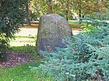
The former colonial stone

The "Park restaurant at the Völkerschlachtdenkmal"


Web links
- Wilhelm-Külz-Park. In: Website of the city of Leipzig. Retrieved March 24, 2016 .
Individual evidence
- ↑ Official city map of Leipzig
- ↑ Table sheet No. 11 from 1908
- ^ Thonberg - A historical and urban planning study . PRO LEIPZIG 2003, p. 18
- ↑ Gina Klank, Gernot Griebsch: Lexicon of Leipzig street names . Verlag im Wissenschaftszentrum Leipzig, 1995, ISBN 3-930433-09-5 , p. 45
- ^ Probstheida - A historical and urban planning study . PRO LEIPZIG 1996, p. 22
- ↑ WolkenSchachLenkWal. In: Website of the Mehrweg e. V. Accessed March 24, 2016 .
Coordinates: 51 ° 18 ′ 55.6 ″ N , 12 ° 24 ′ 25.3 ″ E