
October 18th Street
| October 18th Street | |
|---|---|
|
|
|
 |
|
| Southeast direction (2015) | |
| Basic data | |
| place | Leipzig |
| District | Center-Southeast, Probstheida |
| Name received | March 5, 1909 |
| Connecting roads | Windmühlenstraße, An der Tabaksmühle |
| Cross streets | Johannisallee, Semmelweisstrasse |
| Places | German place |
| Buildings | German Library , Old Fair |
| use | |
| User groups | Cars, cyclists, pedestrians |
| Road design | mostly four lanes, lined with linden trees, interrupted at the southern end |
| Technical specifications | |
| Street length | 2.6 km |
The Straße des 18. Oktober in Leipzig leads as a continuation of the Windmühlenstraße from Bayrischer Platz in a southeast direction to the Völkerschlachtdenkmal . Its name recalls the day of the decisive victory of the Allied troops over Napoleon in the Battle of the Nations near Leipzig , October 18, 1813.
Course and development
From Bayrischer Platz to Semmelweisstraße, Straße des 18. Oktober runs in four lanes, with a bicycle and footpath on both sides, which are separated from the road by a row of linden trees . On the northeast side, a point high-rise of the type PH 16 is followed by three old buildings in closed development up to the corner of Johannisallee, after which the building line is aligned on this side of the street. An eight-story structure over 290 meters long and made up of eleven parts offset from one another contains student apartments. It is bordered by two further point high-rise buildings.
The buildings on the south-western side are more than 50 meters away from the street behind meadows, trees and parking lots. There are eight eleven-storey prefabricated residential panels of type P2 , which are connected by access roads. Your row is interrupted by a high-rise building and a shopping facility and is completed by a building in a data center that is no longer in operation.

Shortly before Semmelweisstrasse, the road makes a slight bend of 5 degrees to the left. According to older ideas, the Völkerschlachtdenkmal and the tower of the New Town Hall should be visible at the ends of the street. But that could not be realized. So you can see the town hall tower on one side as far as Semmelweisstrasse and on the other the tower of the former Soviet exhibition hall with the red star and only after the bend the Völkerschlachtdenkmal.
100 meters after Semmelweisstrasse, the street divides and forms Deutsches Platz, where the Deutsche Bücherei, with its 2011 expansion, and the Max Planck Institute for Evolutionary Anthropology face each other.
The entrance to the old exhibition center is built over and only used on two lanes. Of the two lanes on Straße des 18. Oktober, which are 50 meters apart, only the one following the entrance is used for motor traffic. The other is reserved for bicycles and is partly built on. Converted trade fair exhibition halls and a new administration building for the Deutsche Bundesbank are located on the Fahrstrasse .
The continuation of Straße des 18. Oktober in Wilhelm-Külz-Park to Straße An der Tabaksmühle in front of the Völkerschlachtdenkmal cannot currently be reached from the exhibition grounds due to the lack of a bridge over the railway site. The bridge for pedestrians and cyclists should be restored in 2023.

The beginning of the street at the Bayerischer Bahnhof

P2 prefabricated buildings
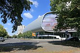
The extension of the German library

At the old exhibition center

In the Wilhelm-Külz-Park


history
First considerations about the construction of the road arose in connection with the competition to build the Monument to the Battle of the Nations in the last years of the 19th century. According to a development plan from 1899, the main axis of the outer southern suburb was to be aligned with the Monument to the Battle of the Nations, which was under construction. A wide boulevard was considered, which was first given its name in 1909 after a long discussion in the city council.

On a city map from 1914, the street is only built on on what will later be the site of the Technical Fair, on which the 1913 International Building Exhibition took place a year earlier . The elevated crossing over the railway area towards the Völkerschlachtdenkmal was also completed.
In 1911, the architect Hans Strobel , who was responsible for the expansion of Leipzig, presented a development plan for the outer south-east suburb, according to which the street should be built as a purely residential street with no traffic with stately, four-story houses with front gardens. From 1914, three such houses, which have been preserved to this day, were built at the Johannisallee intersection. Apart from the Deutsche Bücherei (1919), there was no further development , mainly due to the war, until after the Second World War . Allotment gardens and smaller commercial enterprises expanded.
There was no lack of further planning. They ranged from ten huge trade fair hotels to the complete relocation of Leipzig University to the street to party buildings of the National Socialists .
- New residential area
After an ideas competition in 1963, a target plan for a new residential area on Straße des 18. Oktober was available in March 1967 under the heading “Messemagistrale”. Wolfgang Scheibe was the leading architect in the execution planning.
Construction began in February 1968 with the foundations for the boarding schools. During the so-called summer initiative in July 1968, students worked on the construction of the future dormitories, which had been developed from the residential building type of central aisle houses for small apartments.
For the construction of the new residential area, the Neuwiederitzsch panel factory was built in the north of Leipzig, which started producing large panel elements in July 1968, especially for the eleven-storey P2 panel construction , and which was designed for a capacity of around 1,700 apartments per year. From 1969 onwards, the first buildings were constructed using the so-called 60-day technology - 88 apartments in 60 working days from the start of assembly, including expansion.

In just a few years, around 2,050 apartments, around 4,000 boarding places, three school buildings, a school sports hall, three children's combinations , a department store and a swimming pool were built in the residential area for which the name Straße des 18. Oktober became naturalized (although further streets were built to the southwest) . Of the planned district center with restaurant, library and ambulance, only the foundation and the basement were built, after which only a department store was built in 1980.
In 1974 the residential area was completed, which became a very popular one, where members of the GDR nomenclature and celebrities also lived, such as Horst Schumann , the first secretary of the SED district leadership in Leipzig , the Gewandhaus music director Kurt Masur , the actress Christa Gottschalk and the pop composer Arndt Bause .
literature
- Christoph Kühn: Äußere Südostvorstadt - A historical and urban study . PRO LEIPZIG 1997
- Gina Klank, Gernoth Griebsch: Lexicon of Leipzig street names . Ed .: City Archives Leipzig. 1st edition. Verlag im Wissenschaftszentrum Leipzig, Leipzig 1995, ISBN 3-930433-09-5 , p. 204 .
- Jens Rometsch: The long way of the trade fair artery - the planning took over 100 years. LVZ on June 20, 2018, p. 18, (online)
Web links
- Haig Latchinian : Leipzig residential area “Straße des 18. Oktober” turns 50. In: Leipziger Volkszeitung , online portal. Retrieved August 7, 2018 .
- LVZ photo gallery. In: Leipziger Volkszeitung, online portal. Retrieved August 7, 2018 .
Individual evidence
- ↑ When is the exhibition bridge coming? Retrieved July 22, 2018 .
- ^ Lexicon of Leipzig Street Names , p. 204
- ↑ Plan of Leipzig 1914. Retrieved on July 20, 2018 .
- ↑ a b Jens Rometsch: The long way to the trade fair artery ...
- ↑ 50 years of the large construction site at the Messemagistrale Straße des 18. Oktober. In: www.industriekultur-leipzig.de, online portal. Retrieved August 7, 2018 .
Coordinates: 51 ° 19 '27.3 " N , 12 ° 23' 28.1" E