Apple stones
To commemorate the Battle of the Nations near Leipzig in 1813, so-called apple stones were set up at important locations during the fighting . There are a total of 50 such monuments in Leipzig and the surrounding area. The Leipzig citizen and writer Theodor Apel (1811–1867) had 44 of these landmarks erected from 1861 to 1864 from his own resources. Six more were then set up privately, from an Apels foundation and associations.
The Apelsteine are originally rectangular pillars made of sandstone about 1.5 m high. For the positions of the coalition troops, the stones have a pointed head (inverted V for allies) and the letter V and for the Napoleonic troops with a round head and an N. The inscriptions on the stones show the name and date of the battle on the side facing the battlefield and the names of the military leaders as well as the troop names and strengths on the other. Two arrows on the narrow sides indicate the course of the front. The directions are indicated on the heads of the stones. Up to no. 42, the rule that the coalition troops were assigned the even numbers and the Napoleonic troops the odd numbers was observed.
Since the sandstone proved to be less resistant and the building activity reached the stones that were initially outside the city, the 19th century began to replace many of the stones with copies (sometimes several times and also made of harder material) and, if necessary, to replace them to be set up differently from the original location. In the process, the size and sometimes also the shape of the originals were deviated from, for example by tapered stones in the west of Leipzig or by plinths and attachments. Some text errors crept in while copying.
Locations and inscriptions
| No. | N / A | location | image | Inscription front | Inscription back | |
|---|---|---|---|---|---|---|
| 1 | N | Wachau, Bornaer Chaussee, 150 m south of the Apelsteinallee confluence Coordinates: 51 ° 16 ′ 47.4 ″ N , 12 ° 25 ′ 53 ″ E |
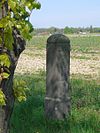 |
VICTOR, HEART. v. BELUNO , II Corps, 20,000 M. |
Battle of WACHAU, October 16, 1813 |
|
| 2 | V | Güldengossa – Liebertwolkwitz road, 1 km north of Güldengossa, next to the Russian-Prussian monument. Coordinates: 51 ° 15 ′ 53.5 ″ N , 12 ° 26 ′ 49.4 ″ E |
 |
Prince Eugene of Württemberg , 10,000 M |
Battle of WACHAU, October 16, 1813 |
|
| 3 | N | Dozen, crossing Markkleeberger Straße / Eigenheimstraße Coordinates: 51 ° 17 '3.5 " N , 12 ° 24' 28.7" E |
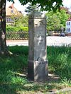 |
AUGEREAU, Duke of Gastilione , IX. Corps, 10,000 M. |
Battle of WACHAU, October 16, 1813 |
|
| 4th | V | Round trip around the Markkleeberger See, at the Crostewitzer Höhe Coordinates: 51 ° 15 ′ 34.2 ″ N , 12 ° 24 ′ 6.7 ″ E The original is in the Museum Torhaus Markkleeberg Coordinates: 51 ° 16 ′ 39.9 ″ N , 12 ° 23 '21.8 " E |
 |
General v. KLEIST , 10,000 men |
Battle of WACHAU, October 16, 1813 |
|
| 5 | N | Bornaer Straße (connection Wachau – Liebertwolkwitz), at the bridge over the S 242 coordinates: 51 ° 16 ′ 52.7 ″ N , 12 ° 27 ′ 3 ″ E |
 |
Count LAURISTON , V. Corps, 15000 M. |
Battle of WACHAU, October 16, 1813 |
|
| 6th | V | S 43 (connection Güldengossa – Großpösna), 900 m before Großpösna Coordinates: 51 ° 15 ′ 39.7 ″ N , 12 ° 28 ′ 39.8 ″ E |
 |
Prince GORTSCHAKOFF , 9000 M. |
Battle of WACHAU, October 16, 1813 |
|
| 7th | N | Holzhausen, Auf dem Kolmberg, 650 m from the junction from Naunhofer Landstrasse Coordinates: 51 ° 17 ′ 23.3 ″ N , 12 ° 29 ′ 21.3 ″ E |
 |
MACDONALD , Duke of Taranto, XI. Corps, 15,000 M. |
Battle of WACHAU on October 16, 1813 |
|
| 8th | V | Großpösna, Querstraße, 80 m south of Fuchshainer Straße Coordinates: 51 ° 16 ′ 24.1 ″ N , 12 ° 30 ′ 18 ″ E |
 |
General Klenau , 9th East Corps, 24,000 M |
Battle of WACHAU, October 16, 1813 |
|
| 9 | N | Liebertwolkwitz, Liprandisdorfer Straße, 70 m from the Ostend junction Coordinates: 51 ° 17 ′ 4.9 ″ N , 12 ° 28 ′ 9.6 ″ E |
 |
Mortier, Duke of Treviso , 2 divisions d. young. Guard, 12,000 men |
Battle of Wachau, October 16, 1813 |
|
| 10 | V | Auenhainer Straße, at the Güldengossa industrial park Coordinates: 51 ° 15 ′ 31 ″ N , 12 ° 27 ′ 44.4 ″ E |
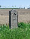 |
Count PAHLEN III. , 3000 riders |
Battle of WACHAU, October 16, 1813 |
|
| 11 | N | Markkleeberg-Ost, Rilkestrasse, Gorkistrasse junction Coordinates: 51 ° 16 ′ 29.9 ″ N , 12 ° 24 ′ 8.3 ″ E |
 |
Prince PONIATOWSKI , VIII. Corps, 8000 M. |
Battle of Wachau on October 16, 1813 |
|
| 12 | V | Großdeuben, Zehmener Straße, on the Pleiße cycle path at the bridge Coordinates: 51 ° 14 ′ 20.6 ″ N , 12 ° 23 ′ 13.4 ″ E |
 |
General BIANCHI , Austrian reserve |
Battle of Wachau on October 16, 1813 |
|
| 13 | N | Wachau, Dösener Weg, 180 m from the Leinestrasse junction, at the old cemetery Coordinates: 51 ° 17 ′ 0.4 ″ N , 12 ° 25 ′ 0.6 ″ E The original is at the Torhaus Dölitz Coordinates: 51 ° 17 ′ 15 ″ N , 12 ° 23 '15.4 " E |
 |
OUDINOT, Duke of Reggio , 3rd u. 4th Division of the Young Guard, 12,000 M. |
Battle of Wachau on October 16, 1813 |
|
| 14th | V | Lindenthal, An der Hufschmiede / Lindenthaler Hauptstraße Coordinates: 51 ° 23 ′ 40.3 ″ N , 12 ° 20 ′ 17.4 ″ E |
 |
Gene. Lieut. St. Priest , 12,000 M Russians |
Battle of Möckern, October 16, 1813 |
|
| 15th | N | Gohlis, Max-Liebermann-Straße / Landsberger Straße Coordinates: 51 ° 22 ′ 31.6 ″ N , 12 ° 21 ′ 39.7 ″ E |
 |
General COMPANS , I. Division |
Battle of Möckern on October 16, 1813 |
|
| 16 | V | Lindenthal, Salzstrasse, in front of the cemetery Coordinates: 51 ° 23 ′ 57.6 ″ N , 12 ° 20 ′ 43.6 ″ E |
 |
General Count LENGERON , 18500 M. Russians |
Battle of MÖCKERN on October 16, 1813 |
|
| 17th | N | Möckern, Georg-Schumann-Straße, in front of house number 206 Coordinates: 51 ° 22 ′ 6.2 ″ N , 12 ° 20 ′ 30.8 ″ E |
 |
General LAGRANGE , II Division |
Battle of MÖCKERN October 16, 1813 |
|
| 18th | V | Lindenthal, Weststraße / Edmond-Kaiser-Straße Coordinates: 51 ° 23 ′ 9.6 ″ N , 12 ° 19 ′ 18.8 ″ E |
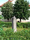 |
Gene. Lieut. v. SACKS , 9000 M Russians |
Battle of MÖCKERN on October 18th (!) 1813 |
|
| 19th | N | Gohlis, Max-Liebermann-Straße, opposite Stadion des Friedens Coordinates: 51 ° 22 ′ 33.3 ″ N , 12 ° 22 ′ 18.2 ″ E |
 |
General FREDERIC , 3rd Division |
Battle of Möckern on October 16, 1813 |
|
| 20th | V | Wahren, Linkelstraße, green area at the corner of Georg-Schumann-Straße Coordinates: 51 ° 22 ′ 28 ″ N , 12 ° 19 ′ 22.2 ″ E |
 |
Lieutenant General von York , I. Pruss. Army Corps, 21,500 men |
BATTLE near Möckern on October 16, 1813 |
|
| 21st | N | Wiederitzsch, Delitzscher Landstrasse / Seehausener Strasse Coordinates: 51 ° 23 ′ 34.6 ″ N , 12 ° 22 ′ 30.5 ″ E |
 |
General DOMBROWSKI , General SOUHAM , General DELMAS, v. III. Corps, a total of 12,000 M |
Battle of MÖCKERN on October 16, 1813 |
|
| 22nd | V | Lindenau, Saalfelder Straße, 50 m southeast of Demmeringstraße Coordinates: 51 ° 19 ′ 57 ″ N , 12 ° 19 ′ 1.2 ″ E |
 |
General Count GYULAI , III. easter. Corps. 17,000 M. |
Battle near Lindenau, October 16, 1813 |
|
| 23 | N | Lindenau, Karl-Heine-Straße / Karl-Heine-Platz, 150 m west of the Felsenkeller Coordinates: 51 ° 19 ′ 56.3 ″ N , 12 ° 20 ′ 11.2 ″ E |
 |
General Count BERTRAND , IV Corps, 10,000 M. |
Battle near Lindenau on October 16, 1813 |
|
| 24 | V | Leutzsch, Benediktusstraße, in front of the swimming pool Coordinates: 51 ° 20 ′ 48.1 ″ N , 12 ° 18 ′ 43.4 ″ E |
 |
Prince of Hessen-Homburg , I. Colonne vom III. Austrian corps |
In memory of the Battle of Nations in Leipzig, battle near Lindenau on October 16, 1813 |
|
| 25th | N | Möckern, Georg-Schumann-Strasse / Seelenbinderstrasse Coordinates: 51 ° 21 ′ 57.5 ″ N , 12 ° 20 ′ 59.5 ″ E |
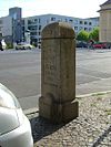 |
MARMONT heart. v. Bagusa (correct Ragusa), VI. Corps, 18,000 M |
Battle of MÖCKERN, October 16, 1813 |
|
| 26th | V | Plagwitz, Antonienstraße / Wachsmuthstraße, 80 m west of the "Adler" Coordinates: 51 ° 19 ′ 13.7 ″ N , 12 ° 19 ′ 44.9 ″ E |
 |
Prince M. Liechtenstein , I. Austrian light division, 5500 M. |
In memory of the Battle of the Nations near Leipzig, battle near Lindenau, October 18th (!) October 1813 |
|
| 27 | N | Holzhausen, Stötteritzer Landstrasse / Mölkauer Strasse Coordinates: 51 ° 18 ′ 36.4 ″ N , 12 ° 27 ′ 8.6 ″ E |
 |
MACDONALD , XI Corps. 12000 M. |
Battle of LEIPZIG on October 18, 1813 |
|
| 28 | V | Baalsdorf, Kurt-Hänselmann-Weg, at the junction from Baalsdorfer Straße Coordinates: 51 ° 19 ′ 6.6 ″ N , 12 ° 28 ′ 30.7 ″ E |
 |
Gener. Count BENNIGSEN , III. Colonne, 65,000 m |
Battle of LEIPZIG on October 18, 1813 |
|
| 29 | N | Schönefeld, Theklaer Straße, near Lazarusstraße Coordinates: 51 ° 21 ′ 40.4 ″ N , 12 ° 25 ′ 10.6 ″ E |
 |
Marshal Marmont , VI. Corps, 15,000 M. |
Battle for Schönefeld on October 18, 1813 |
|
| 30th | V | Schönefeld, Theklaer Straße / Stöhrerstraße Coordinates: 51 ° 21 '57.6 " N , 12 ° 25' 21.8" E |
 |
Gener. Count LANGERON , 30000 M. |
Storming of SCHÖNEFELD on October 18, 1813 |
|
| 31 | N | Probstheida, Dösener Strasse, near Prager Strasse Coordinates: 51 ° 18 ′ 15.8 ″ N , 12 ° 25 ′ 27.9 ″ E |
 |
Victor Lauriston , II. And V. Corps, 30,000 men |
Battle of Leipzig, October 18, 1813 |
|
| 32 | V | Liebertwolkwitz, Monarchenhügel, next to “Monument on Monarchenhügel” Coordinates: 51 ° 17 ′ 32.1 ″ N , 12 ° 26 ′ 39.8 ″ E |
 |
Gener. BARCLAI de TOLLY , 2nd Colonne, 50,000 M. |
Battle of Leipzig on October 18, 1813 |
|
| 33 | N | Lößnig, Bornaische Strasse / Liechtensteinstrasse Coordinates: 51 ° 17 ′ 55.6 ″ N , 12 ° 23 ′ 6.6 ″ E The original is on Torhaus Dölitz Coordinates: 51 ° 17 ′ 15 ″ N , 12 ° 23 ′ 15.4 ″ O |
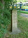 |
PONIATOWSKI , AUGEREAU , VIII. And IX. CORPS; OUDINOT , III. u. IV DIVISION D. JUNG. GARDE, 30000 M> |
BATTLE OF LEIPZIG, OCTOBER 18, 1813 |
|
| 34 | V | Dölitz, Bornaische Strasse / Leinestrasse Coordinates: 51 ° 17 ′ 14.2 ″ N , 12 ° 23 ′ 33.9 ″ E |
 |
Hereditary Prince of Hesse-Homburg , later General von Nostiz, 1st Colonne, 50,000 men |
Battle of Leipzig, October 18, 1813 |
|
| 35 | N | Lindenau, Endersstrasse / Schadowstrasse Coordinates: 51 ° 20 ′ 7.6 " N , 12 ° 19 ′ 53.8" E |
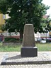 |
Marshal MORTIER , 1st and 2nd 2nd Div. dj G., 10000 M. |
Battle of Leipzig on October 18, 1813 |
|
| 36 | V | Eutritzsch, Delitzscher Strasse, in front of house No. 34 Coordinates: 51 ° 21 ′ 42.9 ″ N , 12 ° 22 ′ 53.8 ″ E |
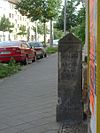 |
Gene. v. Blücher , V. Colonne, Schles. Army, 25,000 M |
Battle of LEIPZIG on October 18th 1813 |
|
| 37 | N | Center-North, North Square , Southwest Corner Coordinates: 51 ° 21 ′ 6.9 ″ N , 12 ° 22 ′ 25.7 ″ E |
 |
General DOMBROWSKI , 5000 M. |
Battle of LEIPZIG, October 18, 1813 |
|
| 38 | V | Heiterblick, Torgauer Straße / Leupoldstraße Coordinates: 51 ° 21 ′ 37.1 ″ N , 12 ° 26 ′ 37.4 ″ E |
 |
Bernadotte CARL JOHANN Crown Prince v. Sweden , 50000 M. |
Battle of LEIPZIG on October 18, 1813 |
|
| 39 | N | Mölkau, Engelsdorfer Straße, in the historic Bergfriedhof Coordinates: 51 ° 19 ′ 57.6 ″ N , 12 ° 26 ′ 48.1 ″ E |
 |
General Reynier , VII Corps, 10,000 M. |
Battle of LEIPZIG on October 18, 1813 |
|
| 40 | V | Paunsdorf, An den Theklafeldern, 30 m before the path in the extension of Waldkerbelstraße, in front of the gardens Coordinates: 51 ° 21 ′ 35.9 ″ N , 12 ° 27 ′ 12.7 ″ E |
 |
Capitain BOGUE, English missile battery |
Battle of LEIPZIG on October 18, 1813 |
|
| 41 | N | Schönefeld, Torgauer Straße, Park Volksgarten entrance Coordinates: 51 ° 20 ′ 58 ″ N , 12 ° 25 ′ 16.5 ″ E |
 |
NEY, Prince vd MOSKWA , left French wing |
Battle of LEIPZIG on October 18, 1813 |
|
| 42 | V | Reudnitz, Dresdner Straße / Stephaniplatz Coordinates: 51 ° 20 ′ 20.7 " N , 12 ° 23 ′ 59.1" E The original is behind the restaurant "Völkerschlachtdenkmal" in Wilhelm-Külz-Park Coordinates: 51 ° 18 ′ 54, 8 " N , 12 ° 24 '35.3" E |
 |
General BUELOW (later) Count v. DENNEWITZ , III. prussia. Corps, 29,000 men |
Storming of LEIPZIG on October 19, 1813 |
|
| 43 | V | Anger-Crottendorf, Volkshain Stünz , west of the pond Coordinates: 51 ° 20 ′ 13.7 ″ N , 12 ° 25 ′ 46.7 ″ E |
 |
Major Carl Friccius , With God for King and Fatherland, 3rd Königsberg Battalion of the 3rd East Prussia. Landwehr Inf. Regiment |
last rest on the night of October 18th to 19th. 1813 before the storm on Leipzig |
|
| 44 | V | Schkeuditz, Leipziger Straße 59, at the Altscherbitz hospital entrance Coordinates: 51 ° 23 ′ 29.7 ″ N , 12 ° 14 ′ 13.5 ″ E |
 |
Lieutenant General of York , 21,500 men |
Last rest of the Silesian Landwehr on the night of October 15-16, 1813 before the battle of Möckern |
|
| 45 | V | Probstheida, Prager Straße, opposite the confluence with Egon-Erwin-Kisch-Weg Coordinates: 51 ° 18 ′ 58.8 ″ N , 12 ° 24 ′ 34.4 ″ E |
 |
The allied monarchs during the storming of Leipzig, October 19, 1813 |
The monarchs receive the council deputation on October 19, 1813 |
|
| 46 | V | Lindenthal, An der Hufschmiede, opposite the confluence with Zum Apelstein Coordinates: 51 ° 23 '31.5 " N , 12 ° 20' 28.5" E The original is on Torhaus Dölitz Coordinates: 51 ° 17 '15 " N , 12 ° 23 '15.4 " O |
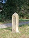 |
GENERAL v. BLÜCHER , SILESIAN ARMY , 60,000 MAN |
SCORER: BATTLE OF MOECKERN, October 16, 1813 |
|
| 47 | V | Wachau, Auenhainer Allee / Oberer Rundweg Markkleeberger See (on the grounds of the Seepark Auenhain) Coordinates: 51 ° 15 ′ 46.7 ″ N , 12 ° 25 ′ 31.9 ″ E |
 |
Field Marshal Lieutenant Graf Weissenwolf, Austria Grenadier Division, 5320 men |
Auenhain sheep farm, October 16, 1813 |
|
| 48 | N | Sellerhausen, Riesaer Straße, in the Sellerhausen cemetery, 30 m from the entrance Coordinates: 51 ° 20 ′ 46.4 ″ N , 12 ° 26 ′ 17.6 ″ E |
 |
General Reynier , VII. Corps, General von Zeschau , Saxon division, 3500 men, last position |
Battle of Leipzig on October 18, 1813 |
|
| 49 | N | Markkleeberg-Ost, Dösener Straße, Am Friedhofseingang Coordinates: 51 ° 16 ′ 36.8 ″ N , 12 ° 23 ′ 54.5 ″ E |
 |
IV. Kellermann Cavalry Corps , 3000 riders |
Battle of Wachau on October 16, 1813 |
|
| 50 | V | Markkleeberg, Kirchstrasse, in front of the Markkleeberg gatehouse Coordinates: 51 ° 16 ′ 39.5 ″ N , 12 ° 23 ′ 22.8 ″ E |
 |
Kaunitz Inf.Reg. No. 20 , 500 men |
Battle of Markkleeberg Castle on October 16, 1813 |
literature
- Theodor Apel: Guide to the battlefields of Leipzig in October 1813 and their landmarks. Hoffmann, Leipzig 1863. ( As PDF file )
- Steffen Poser: Job 38.11. You should come this far and no further, your proud waves should lie here. Monuments tell about the Leipzig Battle of the Nations. Leipziger Hefte, Vol. 13 (published by the Leipziger Geschichtsverein e.V.), Sax-Verlag, Beucha 1998, ISBN 3-930076-66-7 .
- Reinhard Münch: Landmarks and monuments of the Battle of Nations in and around Leipzig. Barthel, Panitzsch 2000, ISBN 3-910188-28-1 .
- Heinz Füßler (Hrsg.): Leipzig 1813. The battle of nations in the national liberation struggle of the German people. Bibliographical Institute, Leipzig 1953.
- Horst Riedel: Stadtlexikon Leipzig from A to Z. Pro Leipzig, Leipzig 2005, p. 21 f., ISBN 3-936508-03-8 .
- Steffen Poser: Monuments to the Battle of Nations . Ed .: Stadtgeschichtliches Museum Leipzig , Passage-Verlag Leipzig 2008, ISBN 978-3-938543-52-8
Web links
- The Apelsteine in the Leipzig Lexicon
- Monuments of the Battle of the Nations near Leipzig
- Apelsteine near the Markkleeberg gatehouse
Individual evidence
- ↑ General Antoine-Guillaume Maurailhac Delmas de La Coste at www.virtualarc.com
- ^ Adolf Schinzl: Nostitz-Rieneck, Johann Nepomuk Graf . In: Allgemeine Deutsche Biographie (ADB). Volume 24, Duncker & Humblot, Leipzig 1887, pp. 30-32.
- ↑ Captain Richard Bogue at Rocket-troop Leipzig 1813
- ↑ Graf Weißenwolf at www.leipzig1813.de

