Batschke
| Batschke | ||
|
The Batschke (shown in red) in the Leipzig water junction |
||
| Data | ||
| location | Saxony , Germany | |
| River system | Elbe | |
| Drain over | Pleiße → Weisse Elster → Saale → Elbe → North Sea | |
| source | as a branch of the White Elster near Kotzschbar ( Zwenkau ) 51 ° 12 ′ 51 ″ N , 12 ° 18 ′ 44 ″ E |
|
| Source height | 120 m above sea level NN | |
| muzzle | In Leipzig in the Pleiße coordinates: 51 ° 18 ′ 19 ″ N , 12 ° 21 ′ 30 ″ E 51 ° 18 ′ 19 ″ N , 12 ° 21 ′ 30 ″ E |
|
| Mouth height | 109.2 m above sea level NN | |
| Height difference | 10.8 m | |
| Bottom slope | 5.5 ‰ | |
| length | 2 km
|
|
| Catchment area | 21 km² | |
| Drain |
MQ |
1 m³ / s |
| Big cities | Leipzig | |
| Medium-sized cities | Markkleeberg | |
| Small towns | Zwenkau | |
|
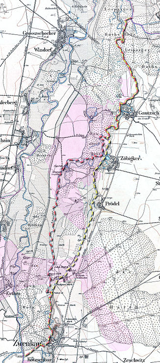
Batschke (red) and the use of raftsmen (yellow) on a map around 1880 |
||
|
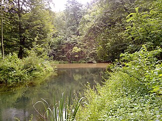
It flows into the sediment-rich Pleiße |
||
The Batschke , also called Floßgraben or officially Batschke - Floßgraben because of its historical use , was one of the numerous tributaries in the anastomosing river course of the White Elster . It was interrupted in the 1970s by the Zwenkau opencast mine . According to plans, its upper course should be re-covered with runoff water from the White Elster from around 2005, but it remains dry to this day. The lower course has been fed by the Lauersche Grenzgraben since 2000 and once the Cospudener See → Waldbad Lauer → Batschke waterway network was completed, it was once again significantly impacted.
Former history

The Batschke branched off from the White Elster to the west of the Zwenkau district of Kotzschbar on the Alten Elsterwehr and flowed through Zwenkau on the eastern edge of the Elsteraue.
South of Budigass it divided into two arms, of which the eastern one continued to follow the edge of the valley and flowed past Prödel and Zöbigker . It was used for rafting and was therefore also called the raft ditch. The western course split again over a short stretch at Cospuden and flowed around it.

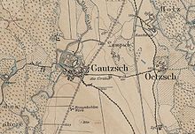
Shortly before the reunification with the Floßgraben between the Markkleeberg districts of Gautzsch , Zöbigker and Gut Lauer (belonging to the city of Leipzig since 1920), another branch branched off the Batschke - the Paußnitz .
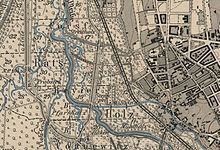
At Gautzsch, the Batschke fed the now dried up moat that enclosed the manor, and then flowed west past Wolfswinkel, a wooded area west of Raschwitz . The Batschke then reached the Ratsholz in the Leipzig district of Connewitz , where it finally flowed northwest of the Panichs Lache oxbow into the Pleiße .
Today's course

Today, the Batschke is no longer a tributary of the White Elster and only runs in the lower reaches from Gautzsch Wasser. The upper and middle reaches have dried up or devastated by lignite mining . In the area of their former middle reaches are today Zwenkauer and Cospudener See . The course of the border between Markkleeberg and Leipzig at the level of the former Paußnitz branch still marks the historical course of the Batschke.
With the connection of the border trench at the level of the Kees'schen Park , the Batschke was renatured east of the Waldbad Lauer (a former gravel pit), while the southern part of its lower reaches that had fallen dry due to the opencast mine remained in a devastated state. With the inflow of the forest pool northeast of the same, it widens and later flows into the Pleiße.
Hydromorphology
The Batschke was about ten kilometers long and an average of five meters wide. The lower course (raft ditch), which again carries water today, is 1960 m long and has an average discharge of about one cubic meter per second.
Due to the agricultural land use in the catchment area of the White Elster since the band ceramics around 7000 years ago and the accelerated erosion , the river is very rich in fine sediments such as sand and silt . The White Elster has therefore deposited about four meters thick layers of clay in its floodplain, which is several kilometers wide.
The so-called alluvial fan did not grow evenly in height. Rather, the river sedimented in the immediate vicinity until oxbow lakes and pools in the rest of the wide valley were a little lower. Especially after floods , the river regularly shifted its main course back into the now lower lying areas until these too were filled with sediment.
These circumstances favored the formation of a widely ramified, constantly changing water network with numerous tributaries and river islands, which today is also called Leipzig water junction in the area of the mouths of the Pleiße and Parthe .
The Batschke, which branched off from the White Elster near Zwenkau, had several tributaries and oxbow lakes. She too changed her bed regularly over the centuries.
Since the regulation of the White Elster in the 19th and 20th centuries, the deposition of alluvial clay has been largely prevented and the watercourses cut deeper into the sediments.
Restoration
Since the beginning of the 1990s, Batschke and Paußnitz have been artificially exposed to Elster water via the Lauer border ditch. Exact advance amounts are specified under water law. The Batschke river bed is supplied with an average flow rate of 160 l / s, while the Paußnitz is irrigated with a quarter of this. The latter has been used specifically since 1993 to cause spring flooding to save the alluvial forest.
After the Cospudener See open-cast mine was flooded, the Untere Batschke was connected to it with a sluice and desludged. In addition, the crossing under the Brückenstraße was made navigable for small boats with a concrete bridge. It is the first completed section of the river network in the Leipziger Neuseenland .
The part of Zwenkau, which had fallen dry when the White Elster was moved to the west in a concrete bed, should not be covered again until 2013 at the earliest, as the much larger open pit at Zwenkauer See was still flooded.
The connection between the Cospuden and Zwenkau lakes then re-establishes the connection between the upper and lower reaches after more than thirty years. This is to be made navigable through a lock that is supposed to overcome the height difference of three meters.
Due to the intended use for water tourism, the Batschke can only be redeveloped into a natural flowing water to a limited extent. The heavy pollution with sulfur salts from the opencast mines also has a negative effect. Renaturation therefore makes the most sense at the Zwenkau section and at the Paußnitz, as both are fed with relatively good water quality directly from the White Elster and are in the area of the last two large remains of alluvial forest in the course of the Batschke.
The section east of the Zwenkau Eichholz will probably be spared from tourism, as the course of a possible touristic connection between the Zwenkau Lake and today's White Elster via the Regulated White Elster is being considered. The renaturation efforts for the southern Leipzig floodplain forest concentrate mainly on the former Batschke arm Paußnitz, as this runs through a nature reserve and cannot be used by water tourists because of the many trees lying across.
The LMBV , which is responsible for post-mining landscapes , and the city of Leipzig are still planning, in close cooperation with the Naturschutzbund Deutschland , to increase the inflow via the Grenzgraben, which not only increases the flow rate of the Paußnitz, but also dilutes the water of the Batschke.
Surname
The Slavic name Batschke is still common in Zwenkau today, while Floßgraben is used for an eastern branch of the Batschke. This was used from 1610 to 1864 for rafting logs to Leipzig and fell victim to the Zwenkau opencast mine. In the trade fair city of Leipzig, the Slavic name has been unusual since it was used for timber transport.
Bridges over the Batschke
- White Bridge
51 ° 18 ′ 9.9 ″ N , 12 ° 21 ′ 21.3 ″ E
Web links
Individual evidence
- ↑ a b Leipzig rivers, 2nd order. (No longer available online.) Archived from the original on January 4, 2014 ; accessed on January 4, 2014 . Info: The archive link was inserted automatically and has not yet been checked. Please check the original and archive link according to the instructions and then remove this notice.
- ↑ Model project for spatial planning (MORO). (PDF; 4.4 MB) Spatial Development Strategies for Climate Change. Regional Planning Association Leipzig West Saxony, March 2012, accessed on February 28, 2012 .
- ↑ top v .: Re-covering of the Batschke in the run-up to the Zwenkau opencast mine. (PDF; 1.8MB) In: Brochure Hydraulic Engineering / Environmental Planning. Ingenieurbüro Lopp , August 2007, p. 3 , archived from the original on February 26, 2013 ; Retrieved February 26, 2013 .
- ↑ Excerpt from sheet 25 (from 1879), topographic map of Saxony 1: 25000 (equidistant map ), edited in the topographic bureau of the Royal General Staff, Leipzig: Giesecke & Devrient, on: deutschefotothek.de
- ↑ a b Meilenblätter von Sachsen 1: 12000 "Berliner Exemplar", recorded 1780–1806 under the direction of Friedrich Ludwig Aster, box M 14433, sheets B18 and B27, on: deutschefotothek.de
- ↑ Excerpt from sheet 26 (from 1876), topographic map of Saxony 1: 25000 (equidistant map ), edited in the topographic bureau of the Royal General Staff, Leipzig: Giesecke & Devrient, on: deutschefotothek.de
- ↑ Excerpt from sheet 11 (from 1908), Topographische Karte Sachsen 1: 25000 (measuring table sheets), department for land survey of the Königl. Saxon. General Staff, Leipzig, on: deutschefotothek.de
- ↑ 51 ° 16 '27.2 " N , 12 ° 20' 44" E
- ^ City of Leipzig, Office for Urban Green and Water
- ^ Judith Gläser: Historical development of alluvial forests in the Leipzig floodplain forest. Dissertation TU Dresden 2002 ( PDF file ( Memento from December 24, 2013 in the Internet Archive ))
- ↑ Redesign of the Leipzig water junction in terms of ecological and morphological continuity , ECOSYSTEMS SAXONIA and TU Dresden, 2005 ( page no longer available , search in web archives: pdf )
- ↑ a b Ralf Julke: Paußnitz flooding does not fail in 2012 either: metal barrier stolen, sandbags should help ( memento from February 11, 2013 in the web archive archive.today ), in: Leipziger Internet Zeitung , March 15, 2012.
- ↑ a b c Master plan for the water tourism usage concept for the Leipzig region ( memento from September 3, 2013 in the Internet Archive ), 2008 (pdf; 2.5 MB)
- ↑ Water tourism usage concept for the Leipzig region (WTNK) - model-based verification of water management feasibility , 2008 ( page no longer available , search in web archives: pdf )
- ^ Topographic map Saxony 1: 25000 (equidistant map ), edited in the topographic office of the Royal General Staff, Leipzig: Giesecke & Devrient, various editions 1874–1918, sheet 25, on: deutschefotothek.de


