Northern Rietzschke
| Northern Rietzschke | ||
|
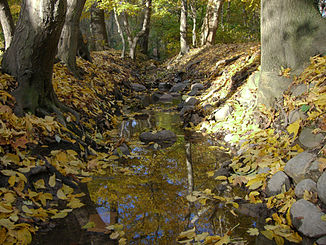
The Northern Rietzschke at Arthur-Bretschneider-Park |
||
| Data | ||
| location | Leipzig , Saxony , Germany | |
| River system | Elbe | |
| Drain over | Sewer → Weisse Elster → Saale → Elbe → North Sea | |
| source | Leipzig- Wiederitzsch 51 ° 23 ′ 31 ″ N , 12 ° 22 ′ 3 ″ E |
|
| Source height | 117.6 m | |
| muzzle | Sewerage in Leipzig- Eutritzsch (formerly in the White Elster , then in the Pleiße or the Gohliser Mühlgraben) Coordinates: 51 ° 22 ′ 6 ″ N , 12 ° 22 ′ 57 ″ E 51 ° 22 ′ 6 ″ N , 12 ° 22 ′ 57 ″ O |
|
| Mouth height | 110.5 m | |
| Height difference | 7.1 m | |
| Bottom slope | 1.9 ‰ | |
| length | 3.7 km | |
The Nördliche Rietzschke is a stream that flows through the northern districts of Leipzig . Its name is derived from the Sorbian word rěčka for "Bach". In terms of water law, it is a second order body of water .
course
The northern Rietzschke has two source streams, the Seehausener Mühlgraben coming from Seehausen and the Lindenthaler Wasser , which has its origin in the west of Lindenthal . The two watercourses come together near the Rietzschkegrund street in Wiederitzsch . Today, the Seehausen side is mainly fed by rainwater and groundwater from the area of the new Leipzig trade fair .
In Wiederitzsch the Northern Rietzschke flows to the southeast, until it takes the Eutritzsch Flur Grenzgraben on the north side of the St. Georg Clinic and turns to the southwest. From the Wiederitzsch railway viaduct to the St. Georg Clinic, the section of the stream was declared a “protected biotope” in 1991 in accordance with the Federal Nature Conservation Act. The Gohliser Flur Grenzgraben opens on the west side of the clinic . The Rietzschke then runs south from the St. Georg Clinic to the Eutritzscher Arthur-Bretschneider-Park , which was laid out in the Rietzschke-Aue at the beginning of the 20th century. This is where the Nördliche Rietzschke joins the sewer network on Gottschallstrasse .
Up until around 1885 it was still an open watercourse from here, flowing into the Pleiße, which was then flowing there , roughly along Kanalstrasse and today's Prellerstrasse. In order to relieve the sewage system when there is heavy water flow, there is a rain overflow into the Parthe on Wilhelmsteg, a cycle and walkway over the Parthe, which now flows there, near the southern end of Prellerstraße (until 1947 Wilhelmstraße).
Up until around 1000, the Nördliche Rietzschke continued to flow to its confluence with the Weisse Elster in the bed that the Parthe uses today. Around 1200, the Gohliser Mühlgraben was built from the Parthe in the area of today's zoo to the Rietzschke in Gohlis (today around Prellerstraße) in order to supply the mill there with sufficient water. The amount of water in the Rietzschke was not enough. Since that time, the Mühlgraben has been referred to as the Pleiße in most maps , as its water primarily came from the Pleißemühlgraben . Since then, the Rietzschke has flowed into the Gohliser Mühlgraben, known as the Pleiße, until it was integrated into the sewer system.
additional
From the confluence of the source streams to the influence in the sewer system, the northern Rietzschke has a length of 3.7 kilometers.
The area around the Nördliche Rietzschke belongs to the Leipzig landscape protection areas . Since 2007 the Rietzschke hiking trail has led from Arthur-Bretschneider-Park along the Rietzschke or near it to Wiederitzsch.
In the east of Leipzig there is a similarly large brook called Östliche Rietzschke , which was also a former tributary of the Parthe.
Individual evidence
- ↑ a b Topographic map of Saxony 1: 25000 (measuring table sheets), department for land survey of the Königl. Saxon. General Staff, Leipzig, various editions 1905-1942, sheets 11 and 26 on: deutschefotothek.de
- ↑ Leipzig rivers, 2nd order
- ↑ a b Horst Riedel: Stadtlexikon Leipzig from A to Z , p. 502. PRO LEIPZIG, Leipzig 2005, ISBN 3-936508-03-8
- ↑ Georg Grebenstein: The Leipzig waters from the turn of the millennium to the present , in: Neue Ufer 3, pp. 5, 8, 18f., Stadt-Kultur-Projekt Leipzig, Leipzig 1995
- ^ Map of the Leipzig landscape protection areas
