
Zwenkau lake
| Zwenkau lake | ||
|---|---|---|

|
||
| Sunrise at Lake Zwenkau - Zitzschen shore | ||
| Geographical location | In the south of Leipzig | |
| Places on the shore | Zwenkau (urban area, Zitzschen ), Leipzig ( Knautnaundorf ) | |
| Data | ||
| Coordinates | 51 ° 14 '22 " N , 12 ° 18' 19" E | |
|
||
| Altitude above sea level | 113.5 m | |
| surface | 9.7 km² | |
| volume | 0.172 km³ | |
| scope | 22 km | |
| Maximum depth | 48.5 m | |
| Middle deep | 17.7 m | |
|
particularities |
Open pit mine |
|

The Zwenkauer See is an artificially created lake approx. 12 km south of Leipzig city center in the heart of the Leipzig New Lakeland . It emerged from a remaining open pit ( brown coal mine Zwenkau ), which was released for tourist use on May 9, 2015. With an area of 9.7 km² and a circumference of 22 km, the Zwenkau Lake is the largest lake in the Leipzig New Lakeland.
Location and shape
The Zwenkauer See is located about twelve kilometers south-southwest of Leipzig city center, southeast of the Leipzig district Knautnaundorf and northeast of the Zwenkau district Zitzschen ; Both Leipzig and Zwenkau have shares in the lake area. The shortest distance to the north located Cospudener See is about 700 meters. The A 38 runs between the two lakes . To the north of this is the Belantis amusement park .
The Zwenkauer See has an irregular shape due to the mining requirements. In its 70-year history, the Zwenkau opencast mine encircled the city in almost a three-quarter circle, coming from the south past the city to the east and north. Although large parts of the opencast mining area were recultivated and now form the Neue Harth , the access to the mine east of Zwenkau had to remain open until the end. The last mining areas in the north-west of the city are just as unfilled. Therefore, the lake runs east of Zwenkau for about two kilometers in a north-south direction with a width of 400 meters, then turns to the west after a northeast bulge to 600 meters and opens to an approximate triangle of 2.5 kilometers Edge length.

The lake has a water surface of 970 hectares and is therefore the largest body of water in the Leipziger Neuseenland and after Geiseltalsee (1850 hectares) and Goitzsche (1330 hectares) the third largest in the central German lake district , larger than the Tegernsee (908 hectares). The greatest depth of the lake at the sites of the last coal mining is 48.5 meters and the mean depth is 17.7 meters. But there are also shallow water areas. The circumference of the lake is 22 kilometers and its total volume 172 million cubic meters.
In addition to the Zwenkau area, the Zwenkau Lake also encompasses the districts of the former villages of Bösdorf and Eythra , which were relocated and excavated from 1980 to 1987. An information board on the south side of the lake recalls the history of Eythra.
Flooding


In 1999, the open-cast mine was stopped, and the Lausitzer und Mitteldeutsche Bergbau-Verwaltungsgesellschaft mbH (LMBV) began to build the embankment systems as an important prerequisite for filling the future Zwenkau lake. To this end, around 14.5 million cubic meters of earth had been moved by the end of 2009.
When the drainage of the pit ceased with the cessation of the production operation, groundwater and rainwater began to collect in the remaining hole. Active flooding started in January 2007. The water is brought in via a 63-kilometer circular pipeline that connects the lakes of the Leipziger Neuseenland with the United Schleenhain and Profen opencast mines, which are still active . The water falls there as swamp water when draining the opencast mines. About 45 cubic meters of water are fed into the Zwenkau residual hole every minute. At the beginning of the flooding, this resulted in a daily rise in the water level of around two centimeters. With the lake's surface area increasing continuously, this value has now dropped below one centimeter per day.
To accelerate the flooding and to protect against flooding, a connection to the neighboring White Elster was established. This consists of a tee and a transfer structure in the form of an approximately 600-meter-long canal between the river and the lake and began operating in 2013. The withdrawal of water (up to a maximum of 3 m³ / s) from the White Elster will only be permitted if its water flow is at least 8 m³ / s. As a rule, the water withdrawal is 1.7 m³ / s, otherwise the crossing footpath and bike path will be flooded. By introducing the Elster water, a daily increase in the water level of around 2 centimeters is achieved. The end of flooding at a final water level of 113.5 m above sea level. NHN should be reached by the end of 2014. Due to the flood in June 2013 , 130 m³ / s Elster water was discharged into the lake through the Zitzschen intake structure, which was completed on May 8th. As a result, the lake level rose by 2.55 m within just under three days. The intake structure cost 12 million euros, which amortized quickly. The current water level (June 3, 2015) is over 112.41 m above sea level. NHN. In order to continue to serve the flood protection until the completion of an outlet structure, the flooding regime was changed: The flooding originally planned for 2014 will probably not be reached until 2015.
As in many remaining mining holes, there is also the problem in Lake Zwenkau that the oxidation of the pyrite in the waste material under the action of water and oxygen produces iron hydroxide and sulfuric acid , and the water becomes acidic . The iron hydroxide causes the unsightly brown coloring by suspended matter in the water. In order to counteract acidification and to achieve “recreational quality” for the lake water, the LMBV has been adding quicklime dissolved in water to the flooding water from the ring main for neutralization . The neutralization system, which was previously used successfully at Hainer See , processes 26 tons of quicklime per day.
Usage plans
Tourist potential
A lake of this size offers considerable tourist potential for the region and, because of the proximity of the motorway, beyond the region. The city of Zwenkau and the Zweckverband Neue Harth , a committee made up of top representatives from the two cities of Leipzig and Zwenkau, are committed to realizing this potential .


According to a master plan decided in 2005, the association will dedicate itself particularly to the north bank. The following facilities are to be established in the list starting from the east: a port for a sailing club, a holiday village with a maximum of 400 holiday homes, 30 of which are to be built as floating on the lake, including the associated supply structure; After a 350-meter-wide strip of forest, there is a space for a hotel with 150 rooms, then there is a pier with a pier for passenger ships, after a sports park with an upstream sandy beach there is a campsite and another sailing base. In the north-east of the lake there will be a connecting canal to the Cospudener See including a lock to bridge the 3.5 m height difference between the lakes. Then there is a boat connection from Zwenkauer See to the center of Leipzig.
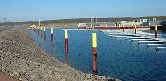
While the north beach is still in the planning phase, there is already brisk construction activity in the middle part of the south beach, i.e. in the north of Zwenkau - called Cape Zwenkau . In addition to a large port area, the infrastructure for a new district of Zwenkau with living and working opportunities is being created here. The harbor basin for a marina is already finished. Since the summer of 2008, the excursion boat Santa Barbara has been operating with a special permit for tours on the lake. It can hold up to 150 people.
As early as April 2006, the Kap Zwenkau exhibition pavilion was the first building in this construction phase. Its architecture is reminiscent of the blown conveyor bridge of the former opencast mine. Information about the mining history of the region is provided in the exhibition room and the surrounding open-air area. In addition, there is an image documentation of "places lost" by the Zwenkau opencast mine: Eythra, Bösdorf and Zwenkau Nord. Above the exhibition level there is a catering level and a managed viewing terrace. From here you have a unique view of the port area, the Belantis amusement park and the Leipzig skyline.
_in_den_Zwenkauer_See.jpg)

Flood protection
The protection of Leipzig from the floods of the Pleiße is ensured by storage areas such as the Borna reservoir and the Stöhna retention basin . Such reserves have not yet existed for the Weisse Elster. The Zwenkauer See is supposed to help. The Zitzschen discharge structure described above is intended to enable the normal water level of 113.5 m above sea level. Above sea level up to 115.5 m above sea level. NHN can also be used as a flood storage tank. With an area of 970 hectares, this results in a storage volume of over 18.5 million cubic meters.
In addition to the abovementioned tipping structure for flooding support, a much larger one, for which the flooding structure is only a bypass, serves as the extraction point for the Elster flood. This allows the transfer of up to 130 m³ / s. Until the completion of the inlet structure, an emergency blasting of the Elsterdeich near Kleindalzig was planned for discharge into the lake in the event of a flood. An outlet structure was built on the northwest corner near Hartmannsdorf, where the Elster, due to its slope and a weir in between, the drainage up to 114.0 m above sea level. NHN enables. In the event of a flood, this flood lamella should be discharged into the White Elster within 21 days. According to the master plan, further emptying of the lake to normal height should take place on the northeast side via the raft ditch , which then leads through the Cospudener See into the Pleiße. The lake was first used as a flood reservoir on June 3, 2013 .
particularities
The registry office in Zwenkau offers interested couples the opportunity to hold the wedding on the lake on board the MS Santa Barbara .
Lake pictures
- Recorded between November 2011 and June 2018
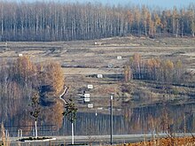
Height markings for flooding on the east bank
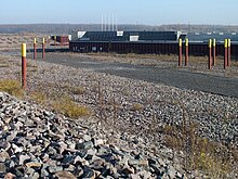
First residential buildings at Cape Zwenkau
Marina

Elsterwasser flows into the lake in March 2013

Zwenkauer See 2018, Zitzschener Ufer

approx. 180 ° panorama of Lake Zwenkau from the lookout point at Cape Zwenkau (looking from west over north to east, 2011)

Panorama Zwenkauer See towards the south, July 2018


Web links
- Zwenkauer See on the website of the city of Zwenkau
- Neue Harth , with a master plan
- Cape Zwenkau
- Webcam port area
Individual evidence
- ^ Website Zwenkau
- ↑ a b Communication from the LMBV dated February 25, 2011
- ↑ Brand new flood protection prevents Leipzig articles of the Free Press, on: freiepresse.de
- ↑ a b Internet presence of the city of Zwenkau On: zwenkau.de
- ↑ LMBV announcement of December 17, 2013
- ↑ Julia Tonne: With lime into bathing pleasure , LVZ of July 12, 2011
- ↑ Registry office Zwenkau
- ↑ Ship wedding ( Memento of the original from June 29, 2011 in the Internet Archive ) Info: The archive link was automatically inserted and not yet checked. Please check the original and archive link according to the instructions and then remove this notice.