
Cospudener See
| Cospudener See | ||
|---|---|---|

|
||
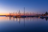
| Cospudener See with Elster and Elsterstausee in front, Markkleeberger See in the background (2005) | ||
| Geographical location | south of Leipzig | |
| Places on the shore | Leipzig , Markkleeberg | |
| Data | ||
| Coordinates | 51 ° 16 '10 " N , 12 ° 20' 7" E | |
|
||
| Altitude above sea level | 110 m above sea level NN | |
| surface | 4.36 km² | |
| length | 4 km | |
| width | 1.7 km | |
| volume | 0.109 km³ | |
| scope | 10.5 km | |
| Maximum depth | 55 m | |
| Middle deep | 25 m | |
|
particularities |
Open pit mine |
|

The Cospudener See is an artificial lake south of Leipzig . It emerged from a remaining open pit that was flooded. The three Saxon cities of Leipzig (district Lauer), Markkleeberg (district Gautzsch and Cospuden ) and Zwenkau (district Eythra) have shares in the lake area .
The lake, often called "Cossi", more rarely "Cospi", offers a variety of leisure, recreation and sports opportunities.
Emergence
The opening of the Cospuden opencast mine (1981) as a branch from the Zwenkau opencast mine occurred during the period of the GDR 's radical coaling policy, which had been pursued since the mid-1970s , in which, as a result of the oil crisis, the aim was to maximize the use of local lignite . The opencast mine, located directly on the southern outskirts of Leipzig, was to be operated in several fields with an annual output of approx. 5–6 million tons by around 1996. Its exposure made it necessary to dig over the agricultural and forestry Elster meadow landscape, a popular local recreation destination south of Leipzig up until then. In addition, several small parts of the settlement, such as B. the former manor Lauer , devastated and a total of 43 residents relocated. The eponymous village of Cospuden (38 inhabitants), the inhabitants of which were resettled in 1974 in connection with the Zwenkau opencast mine, was finally dredged over in the course of 1981. The economic structural change and massive acceptance problems in the population, which were expressed in 1989 in the establishment of the broad citizens' initiative Stop Cospuden , led to the cessation of funding in 1992. Until then, the opencast mine had taken up an excavation area of 5.1 km² and delivered around 32 million tons of lignite to the surrounding processing plants.
Due to the location on the immediate outskirts of Leipzig, the GDR re-use planning already provided for the complete water filling of the remaining hole and the creation of leisure-oriented re-use options after the end of the funding. This core idea was retained during the revitalization of the site. Due to the inflow of groundwater and rainwater as well as swamp water from the Zwenkau (from 1994) and Profen (from 1998) opencast mines, the lake reached its final water level of 110 m above sea level in spring 2000. NN with neutral water conditions.
This made the Cospudener See the first remaining mining lake in the Leipziger Neuseenland that could be handed over for subsequent use. The temporal development advantage compared to the other lakes and the convenient location close to the city caused the comparatively quick establishment of the sophisticated leisure facilities in the area around the lake. These extend far beyond the legally prescribed revitalization services and also beyond the forms of use at comparable residual lakes, since the Cospudener See was viewed as a model project for the possibilities of creating a post-mining landscape . The funding and implementation of the plans was significantly through the theme man, nature and technology related World Exhibition Expo 2000 accelerated to which the Cospuden participated as a decentralized contribution of the city of Leipzig. It was the focus of the contribution Landscape Use - Landscape Management. The Expo was the reason and the motor for the revitalization of the Cospuden opencast mine. As a result, the Cospudener See shows, as an example for the Leipziger Neuseenland, as well as for other brown coal regions in Eastern Germany, which innovative, imaginative and creative ideas for the sustainable design of a post-mining landscape are economically viable in a short time, if the decision-makers involved are close, consensus-based and goal-oriented and work together cooperatively.
Uses
overview
During the recultivation , a local recreation area with a beach and landscaped park was created around the lake and opened on June 1, 2000 as part of the Expo 2000. The leisure activities are for sunbathing and swimming and u. a. Well accepted by sailors , windsurfers , kite surfers , inline skaters , divers and cyclists, so that the Cospudener See has developed into a popular local recreation area. In recent years it has been frequented by an average of around 450,000 people per season. In the course of the Leipzig Olympic application for 2012, competitions in rowing , triathlon and beach volleyball and extensive other leisure activities were planned at the Cospudener See . The lake offers the following uses:
North Shore Landscape Park

- Entrance building with an exhibition on the history of mining and the change in the landscape in the south of Leipzig as well as a bike rental station,
- 1.5 km long landscape and adventure axis from the entrance building to the beach area,
- Tertiary forest (arboretum) consisting of plant communities and geological artefacts that recall the time when lignite was created,
- Water playground,
- 1 kilometer long and 70 meter wide beach with play and sunbathing areas,
- Beach pavilions with service stations (catering, changing rooms, sanitary facilities),
- Landing stage for boat tours,
- Event stage,
- Mini golf course.
Since 2010 the Th! Nk? Festival takes place.
Zöbigker Winkel (east bank)
_2005-09-09.JPG)
- Water sports center Pier I (paddling, rowing, surfing, sailing, kite surfing, diving school , boat rental, etc.)
- 100 meter long marina with three side piers and berths for around 200 boats,
- Landing stage for boat tours,
- three large harbor houses u. a. with service stations, gastronomy with a lake terrace, retail, sauna with lake access, sanitary facilities, holiday apartments,
- Gastronomic facility on the east bank path with restaurant, beach café and beach bar
- Nine-hole golf course
- Diving path with natural and artificial underwater attractions (e.g. underwater forest, boat wreck, parking meter, conveyor belts).
Diocese height (south bank)


- Lookout tower (35 m, 180 steps) on an artificially raised hill ( 135 m above sea level ), view over the lake, the former Elsterstausee , the Belantis amusement park and the skyline of Leipzig
- Wood bison and sika deer herds graze in an enclosure on the bank .
West bank
- Priority and reservation area for nature and landscape protection,
- Minimum ecological network between the landscape protection areas of the Leipziger Auwald in the north and Elsteraue in the south.
Others
- Island mailbox,
- two islands with shipwrecks,
- Eleven kilometers long circular route (completely paved bike and skate path) around the lake with connecting paths e.g. B. to Markkleeberg , Belantis , Elsterstausee , Kulkwitzer See , Grünau , Großzschocher, Schleußig, to the southern Auenwald and to the agra-Park ,
- Boat tours with the MS Cospuden and the solar boat Solaria 1 ,
- Two covered rafts with grill for self-drive,
- Covered pedal mobiles equipped with transparent rain tarpaulins for families and especially people with walking difficulties, which are offered for rent
- diverse events (open-air cinema, dragon boat races, long-distance swimming, concerts by the lake, readings, song evenings, changing exhibitions, etc.)

A newly created canal connects the northern part of the lake navigable (small boats) through the forests of the Elster-Pleiße-Aue with the Pleiße and via the lock at the Connewitz weir also with the Weißen via the forest lake Lauer and the Batschke (today mostly raft ditch) Magpie . Lake Zwenkau, which was flooded until 2015 , is also connected to Lake Cospuden via a navigable ditch three kilometers long, seven meters wide and one and a half meters deep. Both projects are considered to be the first steps in the implementation of a water network between the lakes in the Leipziger Neuseenland.
As part of this network, a large part of the flooded open-cast mining holes is to be connected to each other and to the city of Leipzig via the flowing waters. This artificially connected lake district, which can be used for water tourism purposes, would have better development and marketing opportunities than a number of unconnected individual lakes due to the synergy effects due to the interlinking of the urban landscape, alluvial forests and open pit lakes . Due to the high investments , which are estimated at 30–35 million euros, the participation of private investors and the finding of reliable sponsorship and operator models will be decisive for the implementation of the plans.
particularities
The southern part of the lake belongs to the district of the city of Zwenkau. This means that the registry office in Zwenkau can offer a ship wedding on the lake, on board the MS Neuseenland . The MS Neuseenland , a Hamburg port launch , has been a charter ship on the lake since 2003.
traffic
There is a large visitor car park on Brückenstraße (chargeable during the season). From there it is less than a kilometer to the north beach of the lake. In Zöbigker, and thus on the east beach, there are two more parking spaces: the first is 500 meters from Pier I, the second is directly at the harbor pier and is intended for boat owners and the disabled.

In addition to car traffic, the lake can also be reached by public transport. For example, the 65 bus runs from the parking lot on Brückenstraße to the lake. This bus line can also be used to reach the lake from Markkleeberg station, where the Central Germany S-Bahn runs. The bus line 107 (Leipzig Connewitz – Markkleeberg – Gaschwitz – Zwenkau) also stops in Zöbigker, and the bus stop is less than 300 meters from the east beach. In the summer months, from May to September, the lake can also be reached on weekends with the extended bus route 79 (Thekla – Stötteritz – Probstheida – Cospudener See) .
The lake is still connected to the Leipzig river and canal landscape by a lock in the northern area . This makes it possible to drive from the city harbor in Leipzig to the lake. Not only can smaller sailing ships moor in the harbor, there is also an excursion steamer from Pier I. The ship MS Cospuden operated by Tourismus- und Freizeitservice GmbH has been sailing on the lake since March 25, 2000. It has an upper and a lower deck. A trip including the captain 's yarn takes about an hour.
- Impressions
Marina Zöbigker Hafen

Cospudener See towards Leipzig

Cospudener See in winter

Evening on the south bank with Bistumshöhe and Belantis

Sunset on the south bank


See also
literature
- Christian environmental seminar Rötha e. V. (Ed.): Show change - experience change: Cospuden. Südraum Journal Vol. 12. Leipzig 2000/2001
- Lausitzer und Mitteldeutsche Bergbauverwaltungsgesellschaft (Hrsg.): Creation of open pit lakes in the central German mining district. Berlin 1999
- Lutz Schiffer et al. (Ed.): Mining residual lakes in Central Germany. Nautical compass. Chemnitz / Espenhain 2002
- Lothar Eißmann , Armin Rudolph: Metamorphosis of a Landscape - The Rising Lakes around Markkleeberg Sax, 2002, ISBN 3-934544-27-4
Web links
- General decree Cospudener See with the map on the types of use and the prohibited area.
- The official website of the beach and port operator with all information and current events
- Water depths and topographical profile of the Cospudener See
- Seenkompass - Cospudener See ( Memento from March 20, 2015 in the Internet Archive )
- Map post-mining landscape Cospuden - final state ( Memento from September 28, 2007 in the Internet Archive )
- LMBV information system on current water levels in the Leipzig lakes
- Free circular route map when renting pedal cars across from the harbor master's office
Individual evidence
- ↑ The Cospudener See On: leipzig.de
- ↑ Kamski diving school , information on diving opportunities and a map of diving sites
- ↑ Ship wedding ( Memento of the original from June 29, 2011 in the Internet Archive ) Info: The archive link was automatically inserted and not yet checked. Please check the original and archive link according to the instructions and then remove this notice.