Dog water
|
Dog water backwater |
||
|
The dog water (shown in red) in the Leipzig water node |
||
| Data | ||
| location | Saxony , Germany | |
| River system | Elbe | |
| Drain over | White Elster → Saale → Elbe → North Sea | |
| source | As a branch of the White Elster near Wahren 51 ° 22 ′ 16 ″ N , 12 ° 19 ′ 13 ″ E |
|
| Source height | 104 m above sea level NN | |
| muzzle | At Lützschena in the White Elster Coordinates: 51 ° 22 '39 " N , 12 ° 16' 43" E 51 ° 22 '39 " N , 12 ° 16' 43" E |
|
| Mouth height | 101 m above sea level NN | |
| Height difference | 3 m | |
| Bottom slope | about 0.43 ‰ | |
| length | about 7 km 2,580 m (remaining oxbow lake) |
|
| Big cities | Leipzig | |
|
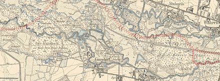
The dog water around 1907 |
||
The dog water was one of the numerous tributaries of the White Elster in its anastomosing river course (often referred to as the inland delta ), which today is an oxbow due to human influence.
It branched off to the left of the White Elster at the Hundewehr in the Leipzig district of Wahren and flowed exclusively into Leipzig's urban area.
Surname
Since at least 1780, dog water has been used as a name for the body of water and dog rifle as a name for the weir system. The designation Hinterwasser is appropriate because the dog water is behind the White Elster when viewed from the northern edge of the floodplain, but there is no official evidence of its use. In the region, however, the term Hinterwasser is colloquially in use.
geography
course
The dog water branched off from the Weißen Elster at the dog gun north of the Auensee , crossed under the Rittergutsstraße (after the relocation the Gustav-Esche-Straße) and then ran almost parallel to the Weißen Elster west through the Burgaue .
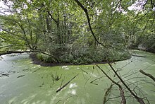
The adjoining lower course, which is still preserved today, flows through the Lützschena Castle Park and joins the White Elster a few hundred meters further on, after crossing under the Hundewasserbrücke.
Hydromorphology
The dog water was about 7 km long and an average width of about 5 m. The remaining underflow is now 2,580 m long and has an outflow of a few liters per second, a hundredth of the original value.
The Elsteraue has a width of about 3 km in the dog water area. The White Elster has therefore developed numerous tributaries such as the dog water, the Luppe or the Batschke . Characterized by many meanders and oxbow lakes, the dog water also has a small tributary in the Lützschena Castle Park.
Until the regulation of the White Elster, which culminated in the construction of the Neue Luppe near Leipzig , additional oxbow lakes and flood channels were flowed through during the annually recurring floods , which otherwise had no connection to the flowing water.
Human interventions
Even before the 19th century, the dog gun was built to regulate dog water.
From 1913 the dog water was used to flood the newly created Auensee, which caused the lake to become heavily muddy. As early as 1914, the construction of an abbreviation for the dog water through the Auensee began. A few years later this was completed and the 500 m long remaining old course was filled.
The most serious intervention was the construction of the Neue Luppe in the 1930s. Like most of the tributaries of the White Elster, the dog water was interrupted and has been an oxbow lake ever since . Its lower reaches are now only fed to a small extent by seepage and rainwater. The upper course has since been backfilled.
See also
literature
- Topographic map Saxony 1: 25000. (Measuring table sheets & equidistant map), Royal General Staff, Leipzig, various editions 1874–1942, on: deutschefotothek.de
Web links
Individual evidence
- ↑ Leipzig River II. Order ( Memento of the original from January 4, 2014 in the Internet Archive ) Info: The archive link was automatically inserted and not yet checked. Please check the original and archive link according to the instructions and then remove this notice.
- ↑ Excerpt from sheet 10 (from 1907), Topographical Map Saxony 1: 25000 (measuring table sheets), department for land survey of the Königl. Saxon. General Staff, Leipzig, on: deutschefotothek.de
- ↑ Meilen Blätter von Sachsen 1: 12000 "Berliner Exemplar", recorded 1780–1806 under the direction of Friedrich Ludwig Aster, box M 14433, sheet 10, on: deutschefotothek.de
- ↑ (New Luppe subsequently drawn in), excerpt from sheet 10 (from 1907), Topographical Map Saxony 1: 25000 (measuring table sheets), department for land survey of the Königl. Saxon. General Staff, Leipzig, on: deutschefotothek.de
- ^ Description of the waters of the Anglerverband Leipzig eV ( page no longer available , search in web archives ) Info: The link was automatically marked as defective. Please check the link according to the instructions and then remove this notice. On: anglerverband-leipzig.de

![The dog water around 1907 [2]](https://upload.wikimedia.org/wikipedia/de/thumb/0/0f/Hundewasser_1907.jpg/326px-Hundewasser_1907.jpg)

