
Lauerscher Grenzgraben
| Lauerscher Grenzgraben | ||
 The Lauersche Grenzgraben |
||
| Data | ||
| location | Saxony , Germany | |
| River system | Elbe | |
| Drain over | Batschke → Pleiße → Weisse Elster → Saale → Elbe → North Sea | |
| source | Effluent from the culvert-fed with water, the white Elster polishing pond 51 ° 17 '18 " N , 12 ° 19' 40" O |
|
| muzzle | After branching off the Paußnitz in Markkleeberg into the Batschke coordinates: 51 ° 16 ′ 58 ″ N , 12 ° 21 ′ 14 ″ E 51 ° 16 ′ 58 ″ N , 12 ° 21 ′ 14 ″ E
|
|
| length | 2.1 km (including culvert) | |
| Big cities | Leipzig | |
The Lauersche Grenzgraben is an artificially created body of water in the south of Leipzig , which serves to supply flowing waters in the southern Leipzig floodplain forest , which have been cut off from their upper reaches by lignite mining . In terms of water law, it is a second order body of water .
Surname
The Good Lauer was a former manor that after 1920 Knauthain was incorporated and come with this 1936 in Leipzig. In 1987 it was demolished in the mining field of the Cospuden opencast mine . The district of Lauer covers about the northern half of the Cospudener See and to the north an approximately 800 meter wide strip of land. The Lauersche Grenzgraben runs near the northern border of the district.
function
While the larger rivers Weisse Elster and Pleiße were relocated and straightened to operate the Zwenkau opencast mine and the subsequent Cospuden opencast mine, smaller rivers such as Batschke and Paußnitz, which flowed through the southern Leipzig floodplain forest, were dredged in their upper reaches. In order to restore Batschke and Paußnitz in their lower reaches , water has been taken from the White Elster via a culvert that crosses under the Elster flood bed and fed to these rivers since the beginning of the 1990s . This happens over the Lauer border ditch.
course
At the beginning of the Lauer border trench, there are two fining ponds for settling sediments carried in from the Elster. A 70 meter long section leads from the first fining pond to the second fining pond. From this the Lauersche Grenzgraben turns in an easterly direction. After about 120 meters the Paußnitzgraben branches off to the north and after 450 meters the Paußnitz. After a change of direction to the southeast, the Kelchstein line and the so-called adventure axis to the Cospudener See are piped under. Here he leaves the Leipzig urban area for Markkleeberg . In the vicinity of the bridge over which the connection path from Lauerschen Waldsee to Cospudener See crosses the Lauerschen Grenzgraben, this is passed in a culvert under the waterway connection of the two lakes, and then flows into the Batschke.
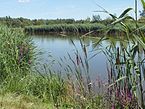
The entire course leads through young deciduous forest, which arose after the area for the opencast mine was cleared and after its excavation was stopped in 1990. The course of the Lauer border ditch can only be recognized in parts by the strip of reed beds that accompany it.
First fining pond - the beginning of the Lauer border ditch

Only a strip of reed marks its course in parts

The Lauersche Grenzgraben near the adventure axis to the Cospudener See

Bridge on the way between Cospudener See and Lauerschem Waldsee


Individual evidence
- ↑ a b Leipzig River II. Order ( Memento of the original from January 4, 2014 in the Internet Archive ) Info: The archive link was inserted automatically and has not yet been checked. Please check the original and archive link according to the instructions and then remove this notice.
- ^ Administrative boundaries of Leipzig (including landmarks) and Office for Statistics and Elections of the City of Leipzig: Official City Map of Leipzig , 2007 edition
- ↑ Fining pond