Kuhburger water
|
Kuhburger water Coburg water |
||
|
The former Kuhburger Wasser (shown in red) in the Leipzig water junction |
||
| Data | ||
| location | Saxony , Germany | |
| River system | Elbe | |
| Drain over | Nahle → Luppe → White Elster → Saale → Elbe → North Sea | |
| source | As a branch of the Kleiner Luppe west of the Palm Garden 51 ° 20 ′ 9 ″ N , 12 ° 20 ′ 29 ″ E |
|
| muzzle | In the area of the Elster basin in the Nahle coordinates: 51 ° 21 ′ 21 ″ N , 12 ° 20 ′ 18 ″ E 51 ° 21 ′ 21 ″ N , 12 ° 20 ′ 18 ″ E
|
|
| length | about 2 km | |
|
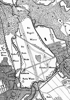
The Kuhburger Wasser on a city map from 1867. |
||
The Kuhburger Wasser (also Coburg water ) was a branch of the Kleine Luppe , which in turn is a branch of the White Elster. It was interrupted by the construction of the Elster basin and later backfilled. The Kuhburg water flowed exclusively on Leipzig city area and was part of the Leipzig water junction .
Surname
The Kuhburger Wasser was named after the Kuhburg, a medieval fortification that was preserved as a cow tower until 1938 , which was located in the area of the northern palm garden and was named after the Lord of Koburg. The name Coburg Water can therefore also be found on the topographic map from 1879.
course
The Kuhburger Wasser branched off from the Kleine Luppe in the area of Lützener Strasse west of the palm garden and crossed under Frankfurter Strasse (now Jahnallee ) a few hundred meters north at the eponymous Kuhburg. It then flowed further north on the western border of the Frankfurt Meadows and, after crossing the Straks and Closed Woods in the area of the Elster basin west of today's sewage treatment plant, flowed into the Nahle .
The historical course of the Kuhburg water still marks the eastern border of the Leipzig district of Lindenau today .
Human interventions
Already about 7000 years ago people began to intervene in the river systems of Pleiße and Weißer Elster. These still indirect changes were limited to agricultural land use in the catchment areas by ribbon ceramists .
As a result, the used soils were eroded much faster (especially sand and silt ) and deposited as loam in the originally gravelly lowland rivers, which made the strong branching of the waters possible in the first place.
In the second half of the 19th century, the Kuhburg water was straightened to a faster drainage of the annual floods and integrated into the system of flood channels that crisscrossed the Frankfurt meadows. The most serious human intervention was the construction of the Elster basin from 1913. The Kuhburg water was dredged in the area of its mouth and the rest was filled in around 1920.
swell
- Miles sheets of Saxony 1: 12000 . “Berliner Exemplar”, recorded 1780–1806 under the direction of Friedrich Ludwig Aster, box M 14433, sheets B18 and B19, on: deutschefotothek.de
- Topographic map Saxony 1: 25000. (Measuring table sheets & equidistant map), Royal General Staff, Leipzig, various editions 1874–1942, sheets 10 and 11, on: deutschefotothek.de
Individual evidence
- ↑ Brief description of the Kuhturm on: leipzig-lexikon.de
- ↑ a b Article on Kuhburger water on: leipzig-lexikon.de
- ^ Topographic map of Saxony 1: 25000 (equidistant map ), edited in the topographic bureau of the Royal General Staff, Leipzig: Giesecke & Devrient, 1879, sheet 11, on: deutschefotothek.de
- ^ Judith Gläser: Historical development of alluvial forests in the Leipzig floodplain forest. Dissertation TU Dresden 2002 ( PDF file ( Memento of the original from December 24, 2013 in the Internet Archive ) Info: The archive link has been inserted automatically and has not yet been checked. Please check the original and archive link according to the instructions and then remove this note. )
- ↑ Restoration of the former watercourses of the Luppe , part 1, bgmr landscape architects, 2006 ( PDF file; 13.7 MB )

