
Parthe

The Parthe is a river in Saxony that rises in the Glastener Forst between Colditz and Bad Lausick and flows into the White Elster after 56.7 kilometers in Leipzig .
course

The Gossenbach and Lehnbach streams of roughly equal size unite in Glasten to form the actual Parthe. Gossenbach is derived from Gossenborn, the historical name of the spring in the area of the village of Glasten, which belongs to Bad Lausick, and Lehnbach is derived from a loan letter from the Saxon Margrave Friedrich des Strengen in 1349, the first mentioning document for the place Glasten.
On its course through the Leipzig lowland bay, the Parthe flows through the communities and cities Groß- and Kleinbardau (districts of Grimma ), Parthenstein , Naunhof , Beucha , Borsdorf , Panitzsch , Taucha and Leipzig.
In Leipzig, until the early 1950s, the Parthe flowed into the Pleißemühlgraben in the zoological garden , which then led to the White Elster. The heavy pollution of the water of the Pleißemühlgraben by the lignite industry was no longer reasonable for the zoo animals, which is why the Pleißemühlgraben at the Natural History Museum was led into the Elstermühlgraben and its bed was filled up to the zoo. Since then, the Parthe alone took over the river bed of the Pleißemühlgraben up to the confluence with the White Elster.
Hydromorphology
From Parthenstein, the Parthe flows in the former bed of the Leipziger Mulde, which united with the Saale in the Old Pleistocene north of today's Leipzig. Mighty gravel deposits around Naunhof date from this time and have so far been used to a large extent to obtain drinking water and building materials. The trough was the end of the Saale cold period sealed off before about 130 thousand to 160 thousand years ago from glacial deposits (Tauchaer moraine), burst in the sequence at Grimma by and flows since in coarse north to Wurzen and Eilenburg on.
The course of the river has been affected by numerous straightening and canalizations since the last third of the 19th century for flood protection, especially in its lower reaches from Naunhof. In the inner city of Leipzig, the Parthe runs partly as a narrow body of water in a wide stone bed.
Tributaries
The Schnellbach , the Gladegraben , the Faule Parthe , the Todgraben , the Mittelgraben , the Grenzgraben , the Threne , the Zauchgraben , the Kittelgraben , the Cunnersdorfer Bach , the Statitzgraben , the Lösegraben , the Hasengraben and the Rüdgengraben flow into the Parthe .
By the end of the 19th century, the Eastern Rietzschke also flowed into the Parthe, but it was integrated into the Leipzig sewer system.

Names
The name of the Parthe is of Slavic origin. It means "the smelly one". The municipality of Parthenstein , the villages of Großbardau (13th century: Parda), Kleinbardau (13th century: Little Parda) and the Parthenaue motorway triangle (where the A 38 joins the A 14 ) are named after her.
Flood

One day before the peak wave of the flood of the century in 2002 reached the city of Grimma an der Mulde, the maximum flood level was recorded on the upper reaches of the Parthe due to the proximity to the Parthen headwaters. On the afternoon of August 12, 2002, part of the fire station, a carpentry shop and various cellars in Großbardau were flooded knee-deep, and even an apartment in Kleinbardau. Between the villages, the Parthe was deepened and canalized around 1940, which occasionally leads to backwater and extensive flooding in the town. At the fire station in Großbardau there is a level with the high water levels since 1980. The level in Leipzig-Thekla can be read online.
The Parthe was also affected by the floods in 2010.
Local recreation and nature conservation
The 51-kilometer Parthe-Mulde cycle route leads over long sections along the Parthe from Grimma via Naunhof, Borsdorf and Taucha to Leipzig. It is part of a network of eight cycle paths between Leipzig, the United and Freiberger Mulde and the Elbe.
In Taucha and Leipzig-Abtnaundorf the Parthe flows through park-like facilities.
The Parthenaue association, to which the cities of Leipzig and Taucha and the municipality of Borsdorf belong, has committed itself to maintaining and maintaining the cultural landscape. Large parts of the course of the river are placed under protection as the "Parthenaue - Machern nature reserve". The project “KunstParcours und ParkNetzwerk Parthe” aims to create a unifying, unmistakable appearance for the Parthenaue and its parks with permanent and ephemeral works of art, with events and art campaigns involving citizens.
Despite the protection of the landscape, the Free State is planning the route of the B 87n through the Parthenaue between Borsdorf and Taucha, against which the protest is directed by citizens' groups. On January 26, 2013, political and social representatives signed the "Taucha Declaration" against the fragmentation of the floodplain and terminal moraine landscape.
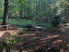
Gossenborn,
one of the Parthe springs in the Glasten Forest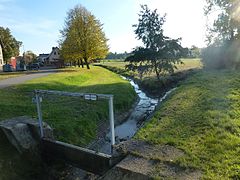
Union of the source streams at Glasten

Two bridges ( B 6 and pedestrian bridge) near Borsdorf

Parthenaue, Abtnaundorf / Mockau

Installation in Abtnaundorf Park

Resistance to the planning of the B 87n through the Parthenaue


.jpg)


additional
At the time of the Third Reich, members of the then banned labor movement could celebrate May 1st undiscovered at the rest huts of the Gossenborn spring. Until the 1970s, the Parthen Festival took place there in the forest in May / June, since then it has been held in Glasten.
literature
- Bettina Weil: Leipziger Brücken , Volume 3: Bridges over the Parthe ; Leipzig: City of Leipzig, Office for Statistics and Elections, 2009; DNB 998356743
Web links
Individual evidence
- ↑ a b U. Haferkorn, K. Müller, U. Mellentin, J. Fahl: Possibilities and limits of material transport modeling using the example of the Parthe area: Final report on the sub-topic: “Determination of the nitrate flow in groundwater and surface water with the Part model based on PCGEOFIM “ ( Memento of September 25, 2007 in the Internet Archive ); Saxon State Office for Environment and Geology, 2002 (pdf; 7.67 MB)
- ↑ a b Dietrich Sames, Birgit Carl: KliWEP - Assessment of the impact of the climate changes forecast for Saxony on the water and material balance in the Parthe catchment area (subsection 2.2.2 Geological overview) Part 2, 2004 (pdf; 1.13 MB)
- ^ German Hydrological Yearbook Elbe Region, Part I 2014. (PDF) State Office for Flood Protection and Water Management Saxony-Anhalt, p. 201 , accessed on November 3, 2018 (from: lhw.sachsen-anhalt.de).
- ↑ a b André Loh-Kliesch, Parthe, in: Leipzig Lexikon (online: http://www.leipzig-lexikon.de/FLUSSSEE/parthe.htm , accessed on February 4, 2019).
- ↑ Gerald Kolditz: The "Taming" of the Parthe in the last third of the 19th century . In: Panitzsch: On the 750th anniversary of the first mention (digitized version)
- ↑ Ralf Julke: Again two crossings of the Parthenaue are to be checked and the citizens' initiative is on the barricades. In: Leipziger Internet Zeitung. February 14, 2019, accessed February 15, 2019 .