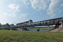
Magpie flood bed
| Magpie flood bed | ||
|
The Elster flood bed near Knauthain |
||
| Data | ||
| location | Saxony , Germany | |
| River system | Elbe | |
| Drain over | White Elster → Saale → Elbe → North Sea | |
| source | Distribution structure Knauthain 51 ° 16 ′ 10 ″ N , 12 ° 19 ′ 4 ″ O |
|
| muzzle | Elsterflutbett coordinates: 51 ° 18 ′ 23 " N , 12 ° 20 ′ 38" E 51 ° 18 ′ 23 " N , 12 ° 20 ′ 38" E
|
|
| length | 4.8 km | |
| Big cities | Leipzig | |
The Elsterhochflutbett or Upper Elsterflutbett is a 4.75 kilometer long artificial river in Leipzig and the right branch of the White Elster . It is used for flood protection.
course
The flood bed begins at the distribution structure of the Weißen Elster in Knauthain . From there it leads east past Knauthain, Knautkleeberg and Großzschocher until it finally flows into the Elster flood bed after 4.75 kilometers .
The Leipzig-Plagwitz-Markkleeberg-Gaschwitz railway line and the district heating ring line run over the flood bed at Großzschocher . The Brückenstraße (S 46), the connecting road between Großzschocher and Markkleeberg , ran through the flood bed until 2013 and was closed in the event of flooding as soon as water was channeled from the distributor structure into the Elster flood bed. In May 2013 a road bridge for the S 46 over the Elster flood bed was completed, which already proved itself during the June floods in 2013 .
Hydromorphology
With normal and low water of the Elster the flood bed does not carry Elster water. However, it is crossed by a ditch along its entire length, which carries water in the last quarter, starting from the Lauer Lehmlache. From there it flows about a kilometer to its confluence with the Elster flood bed.
The trench created in the trapezoidal profile is widened in three places by flooding and filled with water. Two in the flow through and one about two kilometers before the mouth at the level of the Black Lache, which is an oxbow lake of the Paußnitz . Like the Lauer Lehmlache, it is also constantly filled with water and lies next to the dike.
The two widenings through which the water flows are up to one meter deep and characterized by loamy steep banks. In addition to water frogs, they also house roach , perch , pike and carp . Even common toads spawn there. Furthermore, mallards and gray herons can be found in the entire part of the river .
In the case of prolonged drought, only the three deeper pools are filled with water, the rest of the water falls dry.
function
The Elster flood bed relieves the course of the White Elster between Knauthain and Großzschocher.
The distribution structure in Knauthain limits the flow rate of the White Elster. When there is a flood, the excess water flows into the Elster flood bed and ends up in the Elster flood bed.
history
The current Elster flood bed is the remainder of an earlier flood bed that was able to absorb excess water from the White Elster in Eichholz west of Zwenkau and thus significantly reduced the risk of flooding for the former Elster villages such as Eythra , Hartmannsdorf , Knauthain , Großzschocher and Schleußig . The flood bed as a tree-free meadow zone led in dams, which now still has no function in Zwenkau Eichholz, was built around 1870. This flood bed flowed into the former Pleisseflood bed at the Scheibenholz. By relocating the Elster for the Zwenkau opencast mine , the southern part of the flood bed became ineffective and was later interrupted by the opencast mine itself.
literature
- Horst Riedel: Stadtlexikon Leipzig from A to Z. Pro Leipzig, Leipzig, 2005, ISBN 3-936508-03-8 , keywords Weisse Elster , Pleiße , cover pages u. a.
Web links
Individual evidence
- ↑ Archived copy ( Memento of the original from December 4, 2015 in the Internet Archive ) Info: The archive link was inserted automatically and has not yet been checked. Please check the original and archive link according to the instructions and then remove this notice.
- ^ SLUB Dresden: Topographic map (equidistant map) Saxony 1879, sheets 11 and 25

