Hartmannsdorf (Leipzig)
The village Hartmannsdorf is a district of Leipzig . Together with Knautnaundorf, it forms the administrative district of Hartmannsdorf-Knautnaundorf . Hartmannsdorf was an independent municipality until 1992.
geography
Hartmannsdorf is located in the extreme southwest of the urban area about ten kilometers from the city center. It borders in the north on Rehbach and Knauthain , in the east on the Elsterstausee and in the south and west on Knautnaundorf . The town of Bösdorf , excavated by the Zwenkau open-cast lignite mine, was located in the south until 1982 ; Lake Zwenkau has been located there since 2007 .
Starting from the old town center, Hartmannsdorf developed to the south and south-west.
The Weisse Elster and the Knauthainer Elstermühlgraben flow on the southern and eastern outskirts of Hartmannsdorf .
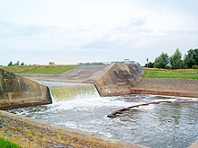
In 1973 the river, Mühlgraben and railway line south of Hartmannsdorf were moved in an arc to the west in order to gain space for the lignite opencast mine. The newly created Elster section between Zwenkau and Hartmannsdorf is popularly known as Betonelster .
history
| Population development | |
| year | Residents |
| 1551 | 16 yards |
| 1764 | 20 yards |
| 1834 | 200 |
| 1871 | 228 |
| 1910 | 543 |
| 1925 | 649 |
| 1939 | 708 |
| 1946 | 743 |
| 1950 | 789 |
| 1964 | 603 |
| 1990 | 583 |
Hartmannsdorf was created in the course of the German East Settlement in 10/11. Century, where probably a locator Hartmann was involved. 1477 were Pflugks on Knauthain from merseburgischen Bishop Thilo with Hartmannsdorf invested . Even in changing men on the manor Knauthain (like the families Schoenberg , Dieskau , Hohenthal ) Hartmannsdorf henceforth remained in the basic rule of good Knauthain.
Hartmannsdorf belonged to the electoral or royal Saxon district office of Leipzig until 1856 . Due to the Saxon rural community order of 1838 , Hartmannsdorf became an independent community, independent of the manor. The patrimonial court associated with the manor was abolished in 1856 and Hartmannsdorf was assigned to the Markranstädt court office. From 1875 the place belonged to the administrative authority of Leipzig .
But there was only a very limited independent infrastructural development. There were no churches, cemeteries, schools or post offices here, and no railway stopping point either. With the exception of a few craft businesses, Hartmannsdorf was dependent on the facilities in neighboring towns. Only the year 1600 at the “Zur Ratte” inn indicates a long tradition of the tavern.
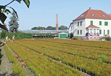
From the middle of the 19th century, horticulture took off (see below), which slowly lost the rural character of the place and instead of the farms, the market gardens dominated, each of which had its chimney for greenhouse heating and its elevated water tank.
The population also increased noticeably. Further structural extensions arose as a result of the settlement of numerous former residents from the villages of Bösdorf and Eythra, which had been devastated because of the lignite .
The Hartmannsdorf community joined the city of Leipzig on January 1, 1993. That was the first incorporation into Leipzig in decades. In contrast to many other villages around Leipzig, Hartmannsdorf decided voluntarily to be incorporated. Since 2001 it has belonged to the Hartmannsdorf-Knautnaundorf district, which was newly formed for administrative purposes .
horticulture
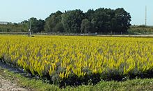
Hartmannsdorf's development has been closely linked to horticulture for over 100 years. In the second half of the 19th century. In 1895 there were five nurseries in the village, and among other things, because of the soil conditions in the Elsteraue, the cultivation of erica and other bog plants emerged. In 1900 a Hartmannsdorf nursery had particular success at a Leipzig flower show with a bright red Erika. In 1914 18 nurseries produced 500,000 Eriken, in the 1920s camellias and azaleas were added to 27 horticultural businesses in the village . In 1933 over a million bog plants were produced.
In the Second World War , there was considerable bomb damage to the greenhouses as well as residential buildings. After the war, vegetables instead of flowers had to be produced to supply the city of Leipzig. At the end of the 1950s the struggle against collectivization began for the now 38 gardeners in the form of horticultural production cooperatives (GPG). Some were able to stay out of the GPG, with corresponding disadvantages (e.g. material supply). In 1982 GPG Hartmannsdorf was the largest exporter of bog plants in the GDR with 40 hectares of open land and 4 hectares under glass as well as two million plants produced.
After the fall of the Berlin Wall , the GPG initially created two companies, which merged in 2007 to form one that is part of an international group. At present (2012) there are still nine private nurseries in Hartmannsdorf.
When streets had to be renamed after the incorporation, reference was made to horticulture with Eriken and Azaleas and Camellias and Heidewegs.
traffic
The A38 motorway , which was opened in 2009 and can be reached via the Leipzig-Südwest junction , runs along the south-western corridor of Hartmannsdorf . Connection to the Leipzig local transport network is via the LVB bus line 63 .
The Leipzig – Probstzella railway runs through the town without stopping. The nearest train station is Knauthain . The railway line, which was originally dead straight throughout the local area, had to evade the Zwenkau opencast mine to the west.
The Erikenbrücke, a pedestrian and cycle path bridge that connects Hartmannsdorf and Knauthain with the region around the northwestern shore of Lake Zwenkau , was opened to public use on June 6, 2017.
literature
- PRO LEIPZIG eV (Ed.): In the Leipziger Elsterland - from Plagwitz to Hartmannsdorf . Leipzig 1997, ISBN 3-9805368-3-1 , pp. 185-196
- Hartmannsdorf . In: August Schumann : Complete State, Post and Newspaper Lexicon of Saxony. 3rd volume. Schumann, Zwickau 1816, p. 701.
Web links
- Hartmannsdorf in the Digital Historical Directory of Saxony
- Information website My district of the city of Leipzig for Hartmannsdorf-Knautnaundorf
Individual evidence
- ↑ Digital Historical Directory of Saxony , accessed on August 19, 2012
- ↑ a b c Im Leipziger Elsterland PRO LEIPZIG, p. 188/189
- ^ Karlheinz Blaschke , Uwe Ulrich Jäschke : Kursächsischer Ämteratlas. Leipzig 2009, ISBN 978-3-937386-14-0 ; P. 60 f.
- ↑ a b website of GASA Germany ( memento of the original from October 19, 2011 in the Internet Archive ) Info: The archive link was inserted automatically and has not yet been checked. Please check the original and archive link according to the instructions and then remove this notice. (accessed on August 18, 2012)
- ↑ “Gärtnerei in Hartmannsdorf, Leipzig” on: GoogleMaps
- ↑ Leipziger Internet Zeitung: Hartmannsdorf: Newly built Erikenbrücke handed over - L-IZ.de. Retrieved June 22, 2017 .
Coordinates: 51 ° 16 ' N , 12 ° 19' E


