
Südvorstadt (Leipzig)
|
district of Leipzig |
|
|---|---|
| Coordinates | 51 ° 19 '15 " N , 12 ° 22' 25" E |
| surface | 2.41 km² |
| Residents | 25,881 (Dec. 31, 2018) |
| Population density | 10,739 inhabitants / km² |
| Postcodes | 04275, 04107 |
| prefix | 0341 |
| Borough | south |
| Transport links | |
| Federal road |
|
| Train | S 1 S 2 S 3 S 4 S 5 S 5X S 6 |
| tram | 9, 10, 11 |
| bus | 60, 70, 74, 89 |
|
Source: District Catalog of the City of Leipzig 2010 Quarterly Statistical Report IV / 2011 statistik.leipzig.de |
|
The district of Südvorstadt is an area of the city of Leipzig that extends between the center of the city and the Connewitz district that was created through incorporation . It was created as an administrative unit in the southern district in its current form when the city was subdivided into municipal territories in 1992. Before that, the area was also known as the outer southern suburb . This is to be distinguished from the inner south suburb , which was assigned to the district center-south by the city administration .
Due to its proximity to the center, but also to larger green areas, the Südvorstadt is a popular residential area with old buildings from the Wilhelminian era . The fact that it is particularly preferred by young people is due not least to the pubs, cabaret and alternative scene developed along Karl-Liebknecht-Straße and the proximity to Leipzig University .
location

The administrative-statistical district of Südvorstadt according to the municipal subdivision of 1992 does not completely coincide with the historically grown district of Südvorstadt. The latter begins immediately south of the inner city ring (so-called Innere Südvorstadt , administratively referred to as "Center-South"). The current district of Südvorstadt, however, only includes the outer Südvorstadt, the northern limit of which was Körnerstraße, Mahlmannstraße and Rennbahnweg (a good 1 km south of Martin-Luther-Ring and 1.7 km south of Leipziger Markt).
The southern border of the southern suburb - to the neighboring district of Connewitz - runs along Richard-Lehmann-Straße ; Until Connewitz was incorporated in 1891, this was also the city limits of Leipzig. In the east, the southern suburb is bounded by the tracks of the Leipzig – Hof railway line ; beyond that is the district center-southeast. In the west it borders on the foothills of the Leipzig floodplain forest , with the west bank of the Elster flood bed , Schleussiger Weg and Wundtstraße being defined as the district boundary. To the west of it lies Schleußig .
The Südvorstadt has - as a statistical district - a north-south extension of 1.2 km and in an east-west direction of 2 km.
history
Until the urban development

Apart from a burial ground from the Iron Age found on today's Arndtstraße, the settlement of the area of the southern suburb began around the year 600 with the old Sorbian village of Lusitz in the area of today's Alfred-Kästner-Straße, which for unknown reasons was in the 14th or 15th centuries . Century was abandoned. In 1241, Margrave Heinrich von Meißen transferred the mill in this village to the nuns of the St. George Monastery in Leipzig . The mill installed this while in 1287 close to the city ( Nuns Mill ) operated but until 1541 at the western end of today Schenkendorfstraße an agricultural Vorwerk .
In the following by Dr. Peter Rothe led Vorwerk there was a dispute between Lutherans and Calvinists in 1593 . After the Calvinist storm that followed in Leipzig , the Vorwerk was burned down and after its reconstruction was now called Brandvorwerk . In 1746 there is talk of an excursion and entertainment restaurant in the Brandvorwerk. In 1844 the Gosenthal restaurant opened near the Brandvorwerk on the border of today's Südvorstadt . It existed with a later hall extension - also under the name Ballhaus Schubert - until 1904.

Until about the middle of the 19th century, most of today's Südvorstadt was a field floor, over which Connewitzer Chaussee ran. The large fairground for the 3rd General German Gymnastics Festival in Leipzig was laid out on it in 1863 , in which 20,000 gymnasts took part from August 1st to 5th.
The urban development

For the anticipated expansion of the city of Leipzig, the city council approved the “General Development Plan for the South Side of the City” in 1864, which included the entire area of today's southern suburb and provided for the construction of checkerboard-like building blocks between partly generously laid out streets at right angles to each other . Only Connewitzer Chaussee retained its curved course as today's Kochstrasse. A number of decorative spaces were planned to be kept free by buildings, which in their conception (tree and path distribution) are still available today (Albrecht-Dürer-Platz, Heinrich-Schütz-Platz).
In the 1870s, the development began from the north and lasted until the 1920s, so that in addition to the historicizing style of the founding years, numerous buildings of Art Nouveau and Art Deco can be found. The houses in the northern area of the Südvorstadt are built in a closed block-edge construction with an inner courtyard, with the courtyards containing further residential buildings as well as buildings for craft businesses. The Saxon building regulations had to be observed. This means, for example, that the houses could not be taller than the streets were wide. Due to new building regulations from 1889, the southern parts of the southern suburb could partly be designed in open construction , ie with single or double houses with a distance of five or ten meters between the houses.

In 1878 the city coal station was relocated to the edge between the state railway to the Bavarian station and Südvorstadt. To the south of it, also on the railroad, the municipal cattle and slaughterhouse was built in 1886–1888 according to plans by city planner Hugo Licht . From 1890–1893, the neo-Gothic St. Andrew's Church was built as the central church building in the district on the former gymnastics festival site according to plans by the architect Georg Weidenbach . The Andreas Church was destroyed in the Second World War and its ruins were blown up in 1958.
Between 1876 and 1896 three schools and a teacher training college were built in the southern suburb. The Royal District Court was established in 1906 on Elisenstrasse (today Bernhard-Göring-Strasse). Due to partial destruction in World War II, its roof design was changed. Today the building houses the Leipzig District Court .
Development after 1945
The air raids on Leipzig in World War II caused severe damage, especially in the eastern part of the southern suburb. Until the 1960s, these were largely remedied by new 4-storey blocks. For the two destroyed schools on Bernhardt-Göring-Straße, a new one, also in large-block construction, was built further south.

Although numerous industrial companies existed in the courtyard areas in addition to craft businesses, most of which were expropriated in the course of the nationalization of the economy in the GDR, the Louis Schopper factory for materials testing machines on Bayerische Strasse (Arthur-Hoffmann-Strasse) , founded in 1922, was the only one with a larger company site . In 1945 it was transferred to the Soviet joint-stock company " Awtowelo ". In 1952, “Awtowelo” built a crane runway hall with a relatively modern architecture on their company premises along Alfred-Kästner-Straße. "Awtowelo" later became VEB Material Testing Machines Leipzig .
After an urban development dominant was lost with the demolition of the Andreaskirche ruin on Karl-Liebknecht-Straße in 1958, a 12-storey high-rise was built on the neighboring corner from 1961 to 1964 as a new dominant and the former square of the church was designed as a green area.
Overall, in the period between 1945 and 1990, as was the case for the entire city, a continuous decline in the old buildings was also evident in the southern suburbs.
Since 1990

As in many of Leipzig's old building districts, the population fell sharply in the early 1990s: between 1991 and 1997, the southern suburb lost around 30% of its inhabitants. During this time, however, the renovation of the old building began. The Südvorstadt is now one of the best redeveloped urban areas in Leipzig. Individual new residential buildings were also created. A larger property of this type is the City Residence on Albrecht-Dürer-Platz. Lofts were built in closed company buildings (e.g. material testing machines, Max Breslauer Art Institute) .
From 1997 to 1999 the broadcasting center of the Mitteldeutscher Rundfunk (MDR) was built on the site of the disused slaughterhouse . The centerpiece is the segment of a circle, 14-story high-rise office building with a glass facade. This is surrounded at the base by a four-storey rectangular building for the production rooms. Further office and technical units, both in new buildings and in some of the former slaughterhouse buildings preserved in yellow clinker construction, complete the facility. In the following years, the Media City Leipzig was built north of the MDR site, also on the former slaughterhouse site. This is practically a commercial area for the media industry with office buildings, studios and workshops. Around 70 companies of various sizes are active here, many of which work directly for the MDR. The television series In all friendship is also produced here.
A branch of the Bundesbank with a tower-like part of the building was built on Karl-Liebknecht-Straße . Four vases on high pillars symbolize the various coin metals.
The Südvorstadt has been one of the most desirable residential areas in Leipzig since the beginning of the 21st century and is considered an example of gentrification . The population has risen steadily since 1997: While the Südvorstadt had 16,909 inhabitants in 2000, it was already 26,019 in 2019.
Population and statistics
The population structure stands out from the Leipzig average in several ways. The average age of the Südvorstädter is quite young at 36.5 years, the age group of 25 to 40 year olds is disproportionately represented and makes up 37.2% of the population. There are also an above-average number of children. The proportion of senior citizens (over 65 years of age) is low at 11.4%. There is a high proportion of academics: 70% of the residents have a high school diploma, 52% have a university degree, 12% have a technical college degree. At 1,765 euros per person or 2,457 euros per household, the net income is well above the median of the city of Leipzig. Only 1% of households live mainly on unemployment benefits. The car quota with 284 private vehicles per 1000 inhabitants and the crime rate with 96 registered crimes per 1000 inhabitants are rather low.
The voting behavior in Südvorstadt also differs significantly from the average values for the city. The turnout is higher (in the 2017 federal election : 84.8%). The Greens have a stronghold here, they received 17.9% of the vote in the 2017 federal election, and even 32.6% in the 2019 state election . The AfD, on the other hand, comes off noticeably weak (2017: 7.7%; 2019: 6.7%).
Culture and leisure
.jpg)
Karl-Liebknecht-Straße with its numerous restaurants, pubs and street cafes as well as small shops is a popular place to stroll and relax. Since a wide range of topics is covered, some call this area of the Südvorstadt a trendy district .
The offers of naTo (“Kulturhaus der Nationalen Front ” during the GDR era ) are also diverse . Concerts, art house cinema, literature readings, theater performances and events on political topics are among the offers of the cultural institution operated by the association culture and communication center naTo eV. The distillery is more special . It is the oldest techno club in East Germany and is considered one of the fifteen most famous and influential techno clubs in Germany. In “Haus Steinstrasse”, the “Haus Steinstrasse eV - Association for Culture, Education and Contacts” strives to provide cultural educational offers for children and young people in the workshops of theater, dance, music, painting, graphics, printing, ceramics, new media, inventions and To build. The house also houses the DachTheater Leipzig, a stage for children and young amateurs. Professionals, on the other hand, dominate the events with audience participation such as “ Riverboat ” or “Sonntag!” In the studios of Media City .

The traditional racecourse Scheibenholz forms the transition to the park and alluvial forest. It was the fourth one founded in Germany, but now only organizes a few days of racing, just four in 2009.
The Fockeberg , which also belongs to the southern suburbs , which was heaped up from the city's war rubble but is now forested, offers a view of the entire city and is a popular place to relax. Sports (Fockeberglauf) and other competitions (soapbox races) are held on its premises.
South of the racecourse is the “Südvorstadt” allotment garden, founded in 1874. It is the second oldest allotment garden in Leipzig.
schools
- Kurt Masur School (primary school)
- School Bernhard-Göring-Straße (elementary school)
- Immanuel Kant School (grammar school)
- Freie Oberschule Leipzig (privately owned)
traffic

The main roads in the southern suburbs are in north-south direction Karl-Liebknecht-Straße (formerly Süd- or Adolf-Hitler-Straße), which is considered to be a promenade , Arthur-Hoffmann-Straße (formerly Bayrische Straße), which is laid out as an avenue August-Bebel-Straße (formerly Kaiser-Wilhelm-Straße) with numerous representative buildings and Wundtstraße as a four-lane connection to the B 2 . Richard-Lehmann-Straße (= B 2, formerly Kaiserin-Augusta-Straße) runs east-west on the southern border and Kurt-Eisner-Straße (formerly Kronprinz-Straße), which connects to the southeast parts of the city has become an essential east-west axis for the entire city via the new Semmelweis Bridge.
Tram lines 9, 10 and 11 as well as bus lines 60, 70, 74 and 89 run through Südvorstadt . All lines (S 1 - S 6) crossing the city tunnel of the S-Bahn Mitteldeutschland stop at the “Leipzig MDR” station on the eastern edge of the municipal area (access Semmelweisstrasse).
The Kochstrasse is of historical importance. It was the old connection route from Leipzig to Connewitz, which was also known as Connewitzer Chaussee . It used to be part of the medieval trading route Via Imperii . From 1872 the Leipzig horse-drawn tram to Connewitz also ran through them .
Impressions from the southern suburb

Art Nouveau facade in Arndtstrasse

Art Deco apartment block on Steinstrasse
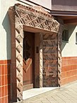
Portal in Steinstrasse

Residential ensemble Lößniger Straße (architect Carl James Bühring )

Lößniger house at the corner of Scharnhorststrasse

In August-Bebel-Strasse

Facade detail in
August-Bebel-Strasse
Refurbished new GDR building on
Arthur-Hoffmann-Strasse


literature
- Outer Südvorstadt - A historical and urban study . PRO LEIPZIG 1998.
Web links
- Information website My district of the city of Leipzig for the southern suburb
- The Brandvorwerk in the Digital Historical Directory of Saxony
Individual evidence
- ↑ Laura Gebhardt, Claus-C. Wiegandt: New city lust? Motives for urban living in the context of the reurbanization debate - the case studies Cologne Sülz and Leipzig Südvorstadt. In: Rainer Danielzyk u. a .: Are you still looking or are you already living? Living in polycentric urban regions. Lit Verlag, Berlin 2014, pp. 141–169, on p. 164.
- ↑ Christina Schmitt, Wolfgang Amann: Gentrification in Leipzig? Data and analysis. In: EinundLeipzig , December 15, 2014.
- ↑ a b Profile of the Südvorstadt district. Leipzig information system.
- ↑ District catalog 2018. Structural data of the districts and districts. City of Leipzig - Office for Statistics and Elections, pp. 145–148 , accessed on May 9, 2020 .
- ↑ Kurt Masur School - former 3rd elementary school celebrates new name. In: LVZ June 1, 2017. Accessed June 3, 2017 .
Abtnaundorf | Althen | Anger | Baalsdorf | Böhlitz | Bösdorf | Breitenfeld | Burghausen | Cleuden | Connewitz | Crottendorf | Dölitz | Doze | Ehrenberg | Engelsdorf | Eutritzsch | Flickers | Göbschelwitz | Gohlis | Gottscheina | Großzschocher | Grünau | Gundorf | Hänichen | Hartmannsdorf | Serenity | Hirschfeld | Hohenheida | Holzhausen | Kleinpösna | Kleinzschocher | Knauthain | Knautkleeberg | Knautnaundorf | Lausen | Leutzsch | Liebertwolkwitz | Lindenau | Lindenthal | Loessnig | Lützschena | Marienbrunn | Meusdorf | Miltitz | Mockau | Möckern | Mölkau | Fog | Neuschönefeld | Neustadt | Neutzsch | Paunsdorf | Plagwitz | Funny | Plop | Portitz | Probstheida | Quasnitz | Rehbach | Reudnitz | Rückmarsdorf | Schleussig | Schönau | Schönefeld | Seehausen | Sellerhausen | Sommerfeld | Stamen | Stötteritz | Stünz | Südvorstadt | Thekla | Thonberg | Volkmarsdorf | True | Wiederitzsch | Windorf | Zuckelhausen | Zweinaundorf