
Karl-Liebknecht-Strasse (Leipzig)
| Karl-Liebknecht-Strasse South Mile, KarLi
|
|
|---|---|
|
|
|
 |
|
| Karl-Liebknecht-Strasse in a southerly direction at the Kurt-Eisner-Strasse intersection (aerial photo 2008) | |
| Basic data | |
| place | Leipzig |
| District | Center-South / Südvorstadt / Connewitz |
| Created | 1880 |
| Hist. Names | Südstrasse, Adolf-Hitler-Strasse |
| Connecting roads | Peterssteinweg, Connewitz Cross |
| Cross streets | Riemannstrasse, Hohe Strasse, Kurt-Eisner-Strasse, Steinstrasse, Kantstrasse, Richard-Lehmann-Strasse , Arno-Nitzsche-Strasse and others |
| Places | South square |
| Buildings | Volkshaus , naTo , Deutsche Bundesbank, HTWK |
| use | |
| User groups | Pedestrian traffic , bicycle traffic , car traffic , public transport |
| Technical specifications | |
| Street length | 2.5 km |
The Karl-Liebknecht-Straße (colloquially Karli ) is a major street in Leipzig , which stretches from the south of the city to the south. The approximately 2.5 kilometer long street extends as a continuation of the Peterssteinweg from the junction of Emilienstraße in the city center south over the southern suburb to the Connewitzer Kreuz in Connewitz .
history
Karl-Liebknecht-Straße was built during the building boom at the end of the 19th century or around 1880. Before that, there was a less paved path here, which followed the course of today's Kochstraße . The route connected downtown Leipzig with Alt-Connewitz.
The northern section of the road to the south square existed in the Middle Ages and was part of the Via Imperii . Until about the middle of the 19th century this section was called Connewitzer Chaussee and from 1839 with the expansion of the Südvorstadt until 1933 it was called Zeitzer Straße . Until 1856, the "outer Peterstor" ("Zeitzer Gate") stood at its southern end . The following section of road out of town from Schenkendorfstraße was called Südstraße from 1874 to 1933 .

The two streets were merged in 1933; it was renamed on March 29, 1933 in Adolf-Hitler-Strasse , on May 18, 1945 under US occupation again in Südstrasse. On August 1, 1945, the street was given its current name under Soviet occupation after the Leipzig KPD co- founder Karl Liebknecht (1871-1919). The house where he was born was at Braustraße 15, a side street off Karl-Liebknecht-Straße. Liebknecht later lived in the house at Südplatz 11, today Karl-Liebknecht-Straße 69. Because of the three renaming within a short period of time, the street was given the joking name "Adolf-Südknecht-Straße" by the people of Leipzig.
After the fall of the Berlin Wall , it was proposed in November 2002 that the street should be named " Straße des 17. Juni ". However, the majority of Leipzig's population rejected this.
Around 2000, especially in the part of Karl-Liebknecht-Strasse between Südplatz and Kurt-Eisner-Strasse, a wide range of restaurants and cafés with numerous street-side outdoor seating developed, which also led to the term “pub mile”.
Other names used by the people of Leipzig for the street are "Südmeile" or "Karli" for short.
traffic

The old course of the road over Kochstrasse served as a route for the Leipzig Horse Railway Company as early as 1872 . In 1881, in a second construction phase, the rail route was relocated across the then Zeitzer and today's Karl-Liebknecht-Straße. In 1896 the line was electrified and went to the great Leipzig tram. When the Leipziger Verkehrsbetriebe (LVB) was founded on July 29, 1938, it took over tram operation. Now the lines 10 and 11 run here and from Richard-Lehmann-Straße the line 9 and the bus line 70. From January 2014 to November 2015, the northern section of the street to Südplatz was completely renovated for traffic. The track systems between the intersection of Kurt-Eisner-Straße and Richard-Lehmann-Straße were renovated in 2018 and equipped with green or grass tracks, among other things for aesthetic and noise protection reasons.
Development
The Karl-Liebknecht-Straße is mostly lined with buildings from the late classicism , historicism , art nouveau and reform architecture epochs, as well as occasionally expressionism and art deco . Some of the gap closings date from the time of the GDR . The building stock has been almost completely refurbished, with the building decorations often being removed from the houses refurbished during the GDR era ( removal of stucco ).
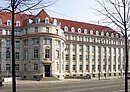
Out of town, the first striking building (no. 8-14) is the administration building of the Association of German Handlers with the 47 meter high dome, which was built from 1913 to 1917 and until 2013 was the administrative headquarters of the Leipziger Verkehrsbetriebe. The Volkshaus (No. 30/32), which has been rebuilt again and again after being destroyed several times, houses the regional representatives of ver.di and the DGB . Opposite it, behind a strip of greenery, is the seven-storey GDR prefabricated building block consisting of four houses , on the ground floor of which there was a large furniture store during the GDR era.
On the left is the house (No. 43) painted by Michael Fischer-Art (* 1969) with comic-like characters, opposite which is the animated neon advertising of the spoon family on the site of the former VEB Feinkost . At the end of the former Zeitzer Straße (No. 44) stands the guard house, which was built in 1856 and which belonged to the Zeitzer Tor at that time and which now houses an Irish pub . No. 46 is the low-rise building of the naTo cultural institution , formerly a reconnaissance center of the National Front . A special monument is the address Südplatz 1. Here, a Wilhelminian style public retreat from 1887 was converted into a snack kiosk in 2010.

The People's House (2013)
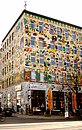
The house designed by Fischer-Art (2007)
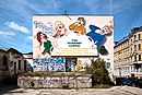
The spoon family at the delicatessen area (2007)
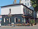
The Guardian House of 1856 (2013)
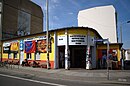
Cultural institution naTo (2007)

The snack in the former retirade (2013)


.jpg)

Opposite Heinrich-Schütz-Platz, which was laid out as a green area by Leipzig council gardener Otto Wittenberg (1834–1918) in 1890, was the St. Andrew's Church, which was damaged in the Second World War until it was blown up in 1958 . In 1964, an eleven-story high-rise apartment building (Scharnhorststrasse No. 17) was built on the edge of the now empty space on the corner of Scharnhorststrasse to replace its function as an urban height dominant. From around Richard-Lehmann-Straße , large buildings dominate, for example a branch of the Deutsche Bundesbank in a new building with a tower-like part of the building (No. 141) . During the GDR era, the district leadership of the SED was housed in the office building (No. 143) on Richard-Lehmann-Strasse . Opposite it with a tower on the corner of Richard-Lehmann-Straße and an extension from the GDR era is the main building of the HTWK ( Geutebrück -Bau), formerly the University of Construction (HfB) and then the TH Leipzig . The 1926 built building house number 145, decorated with expressionist architectural sculpture , was up in the early 1950s by the Oberpostdirektion used Leipzig (→ main post office ). It then served as the seat of the Leipzig District Council ; after the German reunification it was briefly regional council . After extensive construction work, it has been part of the HTWK since 2001 as " Lipsius -Bau".

The skyscraper from 1964 (2009)

The Bundesbank branch (2009)
The former SED district leadership (2006)

The main building (Geutebrückbau) of the HTWK (2005)

The Lipsius Building of the HTWK (2009)


Web links
- Karl-Liebknecht-Strasse in the Leipzig Lexicon. Retrieved April 9, 2015 .
Individual evidence
- ↑ a b Innere Südvorstadt - A historical urban development study - Pro Leipzig 1997
- ^ Otto Künnemann, Martina Güldemann, Manfred Ulmer: Leipziger Straßengeschichte (n) , Wartberg Verlag 1st edition 2006, ISBN 3-8313-1630-9
- ↑ Volker Frank, Helga Elenore Frester, Ulla Heise : "Adolf-Südknecht-Straße" 60 cubits wide. In: Leipzig on foot. 22 city tours. Forum Verlag Leipzig, Leipzig / Hamburg 1990, ISBN 3-87975-543-4 , p. 224
- ^ History of the HTWK Leipzig: timetable, predecessor institutions. (No longer available online.) Archived from the original on May 24, 2015 ; Retrieved April 9, 2015 . Info: The archive link was inserted automatically and has not yet been checked. Please check the original and archive link according to the instructions and then remove this notice.