
Inner Südvorstadt (Leipzig)
The inner southern suburb of Leipzig is a residential area south of the city center. The name is not official. According to the municipal structure of the city from 1992, the area forms, together with the music district and part of the Clara-Zetkin Park, the district center-south in the city district center . The name Innere Südvorstadt only emerged in the second half of the 19th century, when the development of the areas further south began. Until then, the district after the Peterstor was called Petersvorstadt as the entrance from the city center .

Location and local characteristics

The inner south suburb is bordered by the following streets: Grünewaldstrasse, Windmühlenstrasse, Arthur-Hoffmann-Strasse, Kohlenstrasse, Körnerstrasse, Mahlmannstrasse, Wundtstrasse, Floßplatz , Harkortstrasse, Martin-Luther-Ring and Roßplatz . This boundary encloses an area of 0.76 km². The inner southern suburb is bordered by the center in the north, the center-southeast in the east, the southern suburb in the south and the music district in the west.
The Innere Südvorstadt is a purely residential area with the exception of a few public facilities. While in the west and south of the area Wilhelminian style houses dominate in perimeter block development , new buildings from the GDR era can be found primarily in the northeast on Windmühlenstrasse and Arthur-Hoffmann-Strasse, due to destruction in the Second World War .
Although numerous interior areas of the block perimeter buildings and the area surrounding the new buildings have plenty of green space, the raft square is the only public green space in the area. As an open water surface, only about 300 meters of the reopened Pleißemühlgraben belong to the inner south suburb.
history
As in many medieval cities, settlement outside the city wall was also recorded in Leipzig. To the south, this took place on the Via Imperii running through the Peterstor , which later became the Peterssteinweg . Together with branching off streets like Klitschergässchen (today Dimitroffstraße), Kautz or Nonnengasse, the Petersvorstadt emerged . Around 1225, the Cistercian nuns coming from Hohenlohe had built their Georgen monastery in the northwest corner of the area and around 1290 they built a mill called the nun's mill . Brick making and pottery were the predominant trades in Petersvorstadt.
During the Schmalkaldic War , parts of the Petersvorstadt were burned down in 1547 and the areas close to the city wall were not rebuilt for future freedom of fire. From 1610 on, the firewood rafted to Leipzig via the Elsterfloßgraben was stacked on the raft place and the place was converted into a green area after the rafting was closed around 1870. In the second half of the 17th century, the Red and Black Water Art were built near the Nonnenmühle to supply the city with water . From 1749 the free space in front of the Peterstor was designed by planting trees on the esplanade (later Königsplatz or Wilhelm-Leuschner-Platz ), the statue of Elector Friedrich August III. and surround the square with more representative than the usual suburban houses.

Around 1800 there were already around 3200 people living in Petersvorstadt. The Peterssteinweg and the subsequent Zeitzer Straße were built with two to three-story houses. There were numerous places to relax and inns, such as the "Petersschießgraben" at the junction of Münzgasse from Peterssteinweg, behind which there was a shooting range until 1866. The representative five-storey building (coin block) that still exists today was erected on the site of the inn in 1867. There was a large number of garden plots, but also agricultural farms , such as the “Storchsnest” at Emilienstraße, which was named after the last owner of the farm, Emilie Friederike Platzmann (1792–1874).
From 1832 to 1834, the music publisher Hermann Härtel built the Roman House on Peterssteinweg opposite the confluence with Münzgasse with artistic interior fittings. After several changes of ownership, it was demolished in 1904 to allow Härtelstraße to flow into Peterssteinweg. In 1843 the "Tivoli Garden Establishment" was opened on Zeitzer Strasse, on whose property the Volkshaus was built in 1905/1906 .
The opening of the Bavarian train station adjacent to the Inner Südvorstadt in 1842 had a major impact on construction activity in the area. Albert- (today Riemann-), Hohe-, Elisen- (today Bernhard-Göring-) and Bayrische (today Arthur-Hoffmann-) streets were laid out.
In order to ensure the city's development according to plan, the city council approved the “General Development Plan for the South Side of the City” in 1864, which envisaged a chessboard-like road system up to the Connewitz corridor border . According to this plan, the inner southern suburb was first completed, while construction activity in the more southern areas (southern suburb) extended into the 1920s. In the inner south suburb, especially the older houses were replaced by Wilhelminian style buildings.
Public buildings and commercial sites, including a beer brewery, roofing felt and wallpaper factory, were also integrated into the residential district. In the 1920s, the brewery became a canning factory, in GDR times VEB Feinkost, which is still reminiscent of the neon advertising for the “ spoon family ”. From 1875 to around 1890, an area between Peterssteinweg, Harkortstraße, Wächterstraße and Beethovenstraße was expanded into a justice and police district with representative buildings. Between 1882 and 1885, the Peterskirche was built on the site of a former clay pit on Albertstrasse (today Riemannstrasse) as a certain center of the inner southern suburb. In 1873, a private theater building, the Carl Theater, was built in the rear area of the property on Sophienstrasse 17-19 (today Shakespearestrasse). Renamed the Carola Theater in 1877 and the Leipziger Schauspielhaus in 1902 , it remained a private company until 1938. In 1943 it was destroyed by bombs and never rebuilt.

The Königsplatz (around 1840)

Petersschießgraben (inn, 1872)

Vorwerk Storchsnest
(around 1860)
The Roman House
(around 1850)
Tivoli Garden Restaurant
(around 1880)
The Carola Theater (1879)


During the Second World War, the northeast of the inner southern suburb was particularly badly affected by bomb damage. Reconstruction began on Windmühlenstrasse in the early 1950s. Based on plans by Heinz Auspurg (1912–2001), a building complex from Wilhelm-Leuschner-Platz to Emilienstraße was built in brick perimeter development with a plastered facade and porphyry structure with traditional forms in the style of socialist neoclassicism . The later continuation took place across the Windmühlenstraße and along the Arthur-Hoffmann-Straße standing seven and eight-story buildings in large-panel construction.
After the reunification, in addition to the renovation of old buildings, numerous war-related gaps were closed with new buildings. The KPMG administration building on Münzgasse, the office complex for the regional council, now the State Office of Saxony, Leipzig office, and the new St. Trinitatis provost church were built on larger individual buildings .
Current buildings
The main current buildings in the Inner Südvorstadt are as follows:
- The provost church of St. Trinitatis on Nonnenmühlgasse is the main Catholic church in the city. It was built according to a design by the architects Schulz und Schulz and consecrated in 2015. It is the largest new church in eastern Germany since the political change .
- The city library on the south side of Wilhelm-Leuschner-Platz is located in the building built by Hugo Licht (1841–1923) between 1894 and 1897 for the (old) Grassi Museum .
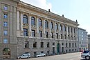
- The Leipzig Police Department , Dimitroffstraße 1, extends essentially along the Peterssteinweg. Together with the public prosecutor's office on Strasse des 17. Juni and the Leipzig Regional Court on Harkortstrasse, it forms a compact judicial / police complex.
- The KPMG administration building from 1996/1997 on the street tip Münzgasse / Straße des 17. Juni with its glass facade, which contrasts with the neighboring stone buildings, is one of the outstanding architectural contributions of the 1990s.
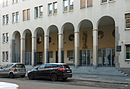
- The LVZ publishing house at Peterssteinweg 19 was built in 1999 through a complete renovation of the post-war printing and publishing building. In 2001, the forecourt was designed with the colonnade.
- The Evangelical Lutheran St. Peter's Church on Gaudigplatz in neo-Gothic style was built between 1882 and 1885 according to plans by the architects August Hartel (1844–1890) and Constantin Lipsius (1832–1894). At 88.5 meters, it has the highest church tower in the city and offers space for 2500 visitors.
- The Wünschmann-Haus , Karl-Liebknecht-Straße 8-14, with its distinctive dome was built in 1914–1917 according to plans by Georg Wünschmann (1868–1937) for the Association of German Handlers as an association house ( VDH building ) and was its headquarters until 2015 the Leipziger Verkehrsbetriebe .
- The Volkshaus , Karl Liebknecht-Straße 30–32, was built in 1905/1906 according to plans by the architect Oscar Schade as an administration and assembly building for several unions. It has belonged to the ver.di union since 2009 .
- The family of SPD co-founder Wilhelm Liebknecht (1826–1900) lived in the Liebknecht House , Braustraße 15, from 1867 to 1881 . Karl Liebknecht (1871-1919) was born here in 1871 . The party headquarters of the Leipzig PDS or Die Linke have been located here since 1998.
- The office building, erected in Braustraße 2 from 1993 to 1996 as a regional council , has served as one of the offices of the State Office of Saxony since 2012.
- The “Feinkostgelände” at Karl-Liebknecht-Straße 36 is a former brewery and, during the GDR era, a food canning factory owned by VEB Feinkost Leipzig. After 1990 shops and cultural institutions of the alternative scene settled. It has been operated by the Feinkost eG art and trade cooperative since 2007 . A monthly flea market is held here as well as summer theater and cinema. The landmark of the site is the " spoon family ", an animated neon neon sign from 1975.

New Provost Church (2016)
City Library (2009)

Police Directorate (2011)
Public Prosecutor's Office (2017)

District Court (2007)

KPMG building (2007)

LVZ publishing house (2004)

Peterskirche (2009)

Wünschmann-Haus (2019), formerly VDH building

People's House (2013)

Liebknecht House (2016)

Regional Directorate (2017)


.jpg)


traffic
The traffic through the Innere Südvorstadt runs north-south, emphasizing the connection between the southern districts and the center. The most important streets in this direction are the Peterssteinweg with the subsequent Karl-Liebknecht-Straße , the Harkortstraße / Dufourstraße and the Arthur Hoffmann-Straße. The tram lines 9, 10 and 11 as well as the bus lines 60 and 89 operate. With the Leuschnerplatz station, the Innere Südvorstadt also has a stop on the S-Bahn network .
education

The school on Floßplatz and the Evangelical School Center are located in the inner south suburb . The former is a municipal elementary school , the building of which was opened in 1872 as the 3rd district school and which housed the POS "Georgi-Dimitroff" during the GDR era . The independent evangelical school center ( Eva Schulze for short ) includes elementary school with after- school care center , high school and grammar school . The historic building is the municipal high school for girls (later the Goethe School ) built by Max Bösenberg and Georg Häckel in 1876/1877 . Some new buildings were built around 2000.
literature
- Bernd Rüdiger: Innere Südvorstadt - A historical and urban study . PRO LEIPZIG 1997
- Vera Danzer, Andreas Dix: Leipzig - A regional history inventory in the Leipzig area . Ed .: Haik Thomas Porada . 1st edition. Böhlau, Cologne Weimar Vienna 2015, ISBN 978-3-412-22299-4 , pp. 174-176 .
Web links
Individual evidence
- ↑ Gina Klank, Gernoth Griebsch: Encyclopedia Leipziger street names . Ed .: City Archives Leipzig. 1st edition. Verlag im Wissenschaftszentrum Leipzig, Leipzig 1995, ISBN 3-930433-09-5 , p. 63 .
- ^ Wolfgang Hocquél : Leipzig - Architecture from the Romanesque to the present . 1st edition. Passage-Verlag, Leipzig 2001, ISBN 3-932900-54-5 , p. 176 .
- ^ Wolfgang Hocquél : Leipzig - Architecture from the Romanesque to the present . 1st edition. Passage-Verlag, Leipzig 2001, ISBN 3-932900-54-5 , p. 184 .
- ↑ Liebknecht House Leipzig. Accessed December 31, 2016 .
Coordinates: 51 ° 19 ′ 51 ″ N , 12 ° 22 ′ 33 ″ E