
Pleißemühlgraben
| Pleißemühlgraben | ||
 The Pleißemühlgraben (shown |
||
| Data | ||
| Water code | DE : 56672 | |
| location | Saxony , Germany | |
| River system | Elbe | |
| Drain over | Leipzig Elstermühlgraben → White Elster → Elbe → North Sea | |
| origin | from the headwater of the Connewitz weir regulating between the Pleisse and the flood bed 51 ° 19 ′ 0 ″ N , 12 ° 21 ′ 29 ″ E |
|
| muzzle | in the center of Leipzig in the Elstermühlgraben coordinates: 51 ° 20 ′ 41 ″ N , 12 ° 22 ′ 11 ″ E 51 ° 20 ′ 41 ″ N , 12 ° 22 ′ 11 ″ E
|
|
| length | 3.2 km | |
| Big cities | Leipzig | |
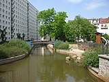
The Pleißemühlgraben (partly also called Pleißmühlgraben ) is an artificially created tributary of the Pleiße in the city of Leipzig .
location
Today it extends over a length of about 3150 meters from the Connewitz Pleißewehr in the south to the confluence with the Elstermühlgraben in the north. The northernmost section, around 580 meters long, from the Natural History Museum to the confluence of the Parthe on the zoo site at that time has been filled in since the 1950s; Since then, the Parthe has been using the former bed of the Pleißemühlgraben from there, while the water from the Pleißemühlgraben is conducted via a short transverse flood canal to the Elstermühlgraben and on to the Weisse Elster .
history
The history of the splices millrace ranges as those of Elster millrace to the 10th century, it originally served the operation of water mills, the nuns mill before today's Karl-Tauchnitz-Straße, Thomasmühle equal to the Thomas Cemetery and the Barefoot mill at today Käthe Kollwitz Street. As the last section of the rafting business operated via Pleiße and Elster , it was also used for timber transport from the middle of the 16th century.
As early as 1899, the part of the Pleißemühlgraben between the Promenaden- (today Käthe-Kollwitz-) and the Centralstraße was arched because of the widening and development of the ring. From 1953 onwards, a large part of the trench was covered with a curved pipe because of the heavy water pollution from the lignite industry. Since 1997, it has been exposed again in stages, sometimes with a slightly different course, and integrated into the cityscape. The sections from Mahlmannstrasse along Wundtstrasse, from Wundtstrasse to Paul-Gruner-Strasse, from Riemannstrasse past the Imperial Court building to Karl-Tauchnitz-Strasse and from Rudolphstrasse to Gottschedstrasse are already open again.
When the plans for the renovation of the Leipzig main fire station became more concrete in 2016, a decision was made about the construction of new courtyard buildings, which would have blocked disclosure in the historical course. The city administration suggested an alternative route along the Goerdelerring so that the courtyard could continue to be used. In the context of public participation until March 2018, the historical course received almost two thirds of the 339 votes cast. The Leipzig city council decided to move it after the administration had forecast an additional cost of 12 million euros for the historic variant.

The beginning at the Connewitz weir (to the right)

Inlet into the piping south of the Schleußiger Weg

The nun mill at Pleißemühlgraben around 1890.

Backfilling the trench in 1951 at the Natural History Museum

Exposure of a piped section in January 2007
The exposed Pleißemühlgraben at the Spießbrücke


literature
- Horst Riedel: Stadtlexikon Leipzig from A to Z. Pro Leipzig, Leipzig 2005, ISBN 3-936508-03-8 , keywords “Pleißemühlgraben”, “Mühlen”.
Web links
- Information from the city of Leipzig on disclosure
- Website for citizen participation in disclosure
- Project to uncover the Pleißemühlgraben in Leipzig On: neue-ufer.de
- André Loh-Kliesch: “White Elster” On: leipzig-lexikon.de
Individual evidence
- ↑ Leipzig Lexicon: Pleißemühlgraben
- ↑ Innere Westvorstadt - A historical and urban planning study . PRO LEIPZIG 1998, p. 22
- ↑ Ralf Julke: In 2017, the people of Leipzig should actually be able to have a say in the new Pleißemühlgraben at the main fire guard. In: Leipziger Internet Zeitung. December 14, 2016, accessed October 23, 2018 .
- ↑ Pleißemühlgraben: Results of the public participation are available. (PDF) City of Leipzig, April 4, 2018, accessed on October 23, 2018 .
- ↑ Mathias Orbeck: “Off to new shores!” City council relocates the Pleißemühlgraben. In: Leipziger Volkszeitung. January 23, 2019, accessed February 7, 2019 .