
Mill splice

The Mühlpleiße is an artificially created branch of the Pleiße in Markkleeberg and the southern urban area of Leipzig . In terms of water law, the Mühlpleiße is a second order body of water .
course
The Mühlpleiße branches off from the Pleiße at the weir in Markkleeberg and initially runs through the agra site in Leipzig. After passing the Torhaus Dölitz and the Dölitzer Mühle, it crosses under the Goethesteig and the Raschwitzer Straße, always running in the border area between the floodplain forest and the settlement area. From Apitzschgasse it flows along the southern edge of the Connewitz development and passes under Wolfgang-Heinze-Straße at the former ice cellar (now Conne Island ). Then it turns west from its generally northerly direction, crosses under Bundesstraße 2 and flows back into the Pleiße at the Hakenbrücke.
The length of the Mühlpleiße is 4.2 kilometers.
history
The Mühlpleiße was created between 1200 and 1250 by the three villages of Dölitz, Lößnig and Connewitz as a joint effort to operate their mills. The branch weir was located between Markkleeberg-Mitte and Markkleeberg-Ost until the Pleiße was relocated and straightened because of the Espenhain open-cast lignite mine . That is why the historic Mühlpleiße was 700 meters shorter. Excess water could be drained off in so-called ditches leading to the Pleiße, of which the Loessniger still exists. Of the three mills, the Dölitzer was in operation the longest, until 1967. It is also the only one whose building still exists. The Mühlpleiße has been driving a 5 kW hydropower plant here since 2006. The Loessniger Mühle was torn down in the 1890s because the forest and water space was needed to build stately villas. The Connewitz mill, which was located at the entrance to Mühlholzgasse, was destroyed in the Second World War. The water from the Mühlpleiße was also used as cooling water by the former power station on Bornaische Strasse.
The course in the picture
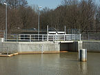
Beginning at the Markkleeberger weir

At the Torhaus Dölitz

Dölitzer mill with hydropower plant

At the Loessniger Abschlaggraben

In Loessnig on Raschwitzer Strasse

At the Apitzschgasse

At the ice cellar

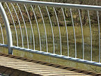
At the filter bridge in Connewitz wood
Muzzle at the hook bridge


literature
- Georg Grebenstein: The Leipzig waters from the turn of the millennium to the present , in: Neue Ufer 3, Stadt-Kultur-Projekt Leipzig, Leipzig 1995
Web links
Individual evidence
- ↑ a b Leipzig rivers, 2nd order. In: Website of the city of Leipzig. Retrieved May 3, 2019 .
- ^ Georg Grebenstein: The Leipzig waters from the turn of the millennium to the present , in: Neue Ufer 3, Stadt-Kultur-Projekt Leipzig, Leipzig 1995, p. 21
Coordinates: 51 ° 16 ′ 49 ″ N , 12 ° 22 ′ 57 ″ E