
Elster-Saale Canal
|
Tributaries and hydraulic structures
|
|||||||||||||||||||||||||||||||||||||||||||||||||||||||||||||||


The Elster-Saale Canal , called the Saale-Leipzig Canal (SLK) by the Federal Waterways and Shipping Administration since 1999 and also called the Saale-Elster Canal on the Halle side, is a canal project started in 1933 and discontinued in 1943 , that would connect the White Elster in Leipzig with the Saale near Leuna and thus connect Leipzig to the north German waterway network via the Saale and Elbe and to the North Sea via Hamburg . The canal was planned for ships up to 1000 tons (about class IV ).
The eleven-kilometer-long flooded section is one of the so-called “other federal waterways ”.
Previous projects

From 1578 the Elsterfloßgraben was created, which led from the White Elster near Crossen to the Saale near Bad Dürrenberg . It was used to transport wood and can still be seen over long stretches of the terrain.
King Friedrich August I of Saxony (1763–1827) initiated the planning of a water connection between Leipzig and the Saale and Unstrut . However, the Napoleonic Wars from 1805 to 1815 stopped these plans and the project was not pursued any further.
On the initiative of the Leipzig entrepreneur and city councilor Karl Heine , who placed the project at the center of Leipzig's economic development, work on the excavation of a canal began on the White Elster in 1856. In 1898 the last construction phase for the time being was completed after a length of about 2.6 km had been reached. This canal was named after its initiator Karl-Heine-Kanal . The Elster-Saale Canal should have been connected to the Karl-Heine Canal via the Lindenau harbor , which would have established the connection through Leipzig city center to the White Elster.
Construction of the canal


On November 16, 1920, a government agreement stipulated the construction of the Elster-Saale Canal , here called the "southern wing of the Mittelland Canal ". In a state treaty concluded on July 26, 1926 for the completion of the Mittelland Canal, the simultaneous start of construction and the completion of this south wing with the Mittelland Canal was expressly stipulated.
On July 11, 1933, work on the canal began near Burghausen . Up to 2000 workers, who were recruited mainly from among the unemployed as part of a job creation measure, were deployed on the construction site, which in 1934 was one of the largest in the German Reich . With a depth of 3.5 m and a water level width of 32 m to 37 m, the canal was designed for two-aisle operation with the then most modern 1000-tonne canal vessels. Work progressed rapidly until 1936, and the armament-related shortage of labor was compensated for by using heavy construction machinery such as bucket chain excavators and scraper belts. In the following years, however, the intensity of the work was further reduced in favor of an accelerated completion of the Mittelland Canal, which is required for the transport of important armaments . The terrain conditions in the planned course of the canal up to the Saale made it necessary to fill some areas of up to 16 m above ground level; this heaped up section is called the dam section . In order to be able to empty the sewer for repair work or in an emergency, a relief system and two security gates were built at Bienitz near Burghausen (security gate east) and Zschöchergen (security gate west, km 7.70). The security gates should seal off the dam section if necessary (in the event of a dam break or repair work); Via the relief system integrated into the dam in the Zschampert , the dam stretch could be emptied in a controlled manner according to the siphon principle or the water level could be regulated during flooding. The Zschampert crosses the canal seven meters below its water level in a 100 meter long underpass. These structures, several steel half-timbered road bridges over the canal and two road underpasses for today's federal highway 186 in Dölzig were completed by 1938. In order to overcome the height difference between the canal and the Saale, work was recently started on a lock staircase with two locks at Wüsteneutzsch . The locks were designed as an economy lock ; the lock chambers had a length of 85 m, a width of 12 m and a jamb depth of 3 m and thus corresponded in their dimensions to the requirements for the lock of 1000 t canal ships. The work, which was further delayed with the beginning of the Second World War in September 1939, was finally stopped completely at the beginning of 1943, but should be continued with the greatest intensity after the "final victory". By this time, around 75 percent of the total construction volume had been completed.
Of the planned 19 kilometers, 11 kilometers were completed and filled with water in 1939, and a further 5.5 kilometers have already been partially excavated. The canal, which was supposed to flow into the Saale at Kreypau , ends near Günthersdorf (Saxony-Anhalt).
The Lindenau harbor

In May 1938, the dredging of the port basin at km 18.76 and the construction of the first storage buildings began . The Lindenau port was planned as an industrial and transshipment port with two industrial and transshipment port basins each. In the first phase, only the construction of an industrial and a transshipment port basin was initially planned. With a length of 1000 m and a width of 70 m, the transshipment port basin was large enough to be able to load and unload two adjacent ships at each of the two quays .
By the time work was stopped in spring 1943, large parts of the port facilities had already been completed. The respective connection to the Elster-Saale and Karl-Heine canals was not completed.
From 1945 to 1996 the already completed storage and warehouse buildings of the port were used. Since then, the buildings on the almost 40 hectare site have been falling into disrepair . The Lindenau harbor and the associated facilities and buildings have been under monument protection since autumn 1997 .
The connection of the port to the Karl-Heine Canal was decided on July 18, 2012 by the city council. On January 29, 2015, the flooding of the 665-meter-long connection between the Karl-Heine Canal and the Lindenau harbor began. The process was completed on schedule three weeks later. On July 2, 2015, the new route was opened for boat traffic.
A start of construction for the approximately 100-meter-long missing connection between the Lindenau harbor and the Elster-Saale Canal is not in sight. The Lyoner Straße will be required as an alternative route during the construction of the new railway bridges on Georg-Schwarz-Straße. The connection can only be established when a barrage for high and low waterfalls has been built in the Karl Heine Canal south of the Luisenbrücke.

The canal today

From 1947 to 1949 there were efforts by Saxon politicians to resume work on the Elster-Saale Canal and to complete it. However, specific resolutions or specifications were never made, especially since the Soviet occupiers were not interested in further construction. The government of the GDR , founded on October 7, 1949 , did not make any stipulations that would have made the canal's completion possible. In the 1950s, for example, one of the two security gates was dismantled in order to build it into a structure on the Oder-Havel Canal . Against the background of the oil price crisis in the 1970s and 1980s, the completion of the canal once again became the focus of interest from state officials, but these considerations were quickly rejected.
The profitability of an Elster-Saale expansion is highly controversial due to the prevailing road freight traffic. Furthermore, the industry that was once located in Leipzig-Plagwitz no longer exists as a potential commercial beneficiary. However, some development associations are making efforts to complete the canal, who see it as an opportunity for tourism in the region under the slogan “From the Elster to the Alster”.
In 2011, the canal came up again, inspired by the Saale-Elster-Canal friends' association founded in 2007 . Half a million tourists and costs of 100 million euros are being discussed every year; at least according to reports that were commissioned by the association itself, but also by the city of Leipzig. A potential analysis was presented in February 2012. The association favors a boat lift next to the lock ruins in Wüsteneutzsch based on the model of the Falkirk Wheel in Scotland .
Despite the tourism benefits envisaged for the region, there are numerous critics. They primarily cite the problem of financing and also doubt that there is sufficient demand. The federal government, as the administrator of the waterways in Germany, has already emphasized several times that this waterway, which is of little value for it, will not be financed beyond the previous maintenance. The state of Saxony-Anhalt and in particular the Saalekreis, where the construction work would take place, have little motivation for financing due to the dubious benefits for themselves. On the other hand, major advocates come from the neighboring towns, the cities of Leuna, Halle and above all Leipzig. However, they cannot manage the project financially on their own. Attempts to hand the channel into private hands with a solid financial base have so far failed.
In addition to the actual construction costs for the completion of the canal, the ship lift and the port facility in Leipzig, there are also enormous follow-up costs for the renovation of the Saale and Elbe, especially if larger passenger ships are used.
The overall tourism management concept for the water landscape in Central Germany, presented in 2015, lists the connection of the canal to the Saale as one of ten lighthouse projects.
The service route on the north side is to be upgraded to an asphalt cycle route.
Impressions

Beginning of the canal in Leipzig

Railway bridge at Rückmarsdorf

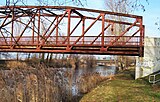
Bridge of the B 181 at Rückmarsdorf

The canal was already used as a rowing route in GDR times

Security gate east near Burghausen

Underpass of the Zschampert under the Elster-Saale Canal

View from the canal to the Zschampert

Relief structure for water level regulation

Canal near Dölzig
Bridge near Günthersdorf, in the background the bridge of the A 9

End of the canal at Günthersdorf

Canal near Günthersdorf

Günthersdorf towards Leipzig


literature
- Denis Achtner: Elster-Saale Canal. From the Karl Heine Canal via the Lindenau Harbor to the lock in Wüsteneutzsch. (= Böhlitzer Hefte. ) 3rd, extended edition. Creativ advertising agency Kolb, Leipzig 2012 ( reading sample ).
- Dirk Becker: The south wing of the Mittelland Canal. By ship from Magdeburg via Merseburg to Leipzig. Projekt-Verlag Cornelius, Halle 2008, ISBN 978-3-86634-609-3 .
- Paul Goetz: The Elster-Saale-Canal from Leipzig to Greypau. Elster-Saale-Canal-Verein, Leipzig 1893 ( digitized ).
- Wolfram Sturm: Leipzig and its ship canals. A historical and urban study. Pro Leipzig, Leipzig 1998.
- Georg Wermert: The economic importance of a shipping route from Leipzig to the Elbe with special consideration of the Saale. Norddeutsche Buchdruckerei, Berlin 1893 ( digitized version ).
See also
Web links
- Pictures and information about the Elster-Saale-Canal and Karl-Heine-Canal at www.ostwall.com
- Saale-Leipzig Canal in the electronic waterway information system (ELWIS)
- Our home Dölzig Website of the OldboysSV1863Dölzig, detailed, historical photo documentation of the construction of the canal and the lock at Wüsteneutzsch (loud background music), on: oldboys1863.de.to
- The official website of the Saale-Elster-Kanal Förderverein eV
Individual evidence
- ^ WSV: Saale and Saale-Leipzig Canal : "In the area of responsibility of outer district 5 [of the WSA] in Merseburg are [...] the Saale-Leipzig Canal." (Accessed on January 11, 2018)
- ↑ a b Directory F of the Chronicle , Federal Waterways and Shipping Administration
- ↑ Leipzig Lexicon
- ↑ a b c DIN 4054 hydraulic engineering; Terms; September 1977
- ↑ Connection of the Lindenau harbor approved: FDP criticizes, water festival organizers cheer article in Leipziger Volkszeitung at lvz-online.de; Retrieved July 22, 2012.
- ↑ Flooding of the waterway connection "Karl-Heine-Canal - Lindenauer Hafen" started. City of Leipzig, January 29, 2015, accessed on February 20, 2015 .
- ↑ 665 meters: Lindenau harbor connected with Karl Heine Canal. Article in the Leipziger Volkszeitung at lvz-online.de; Retrieved July 3, 2015.
- ↑ Ralf Julke: The breakthrough to the Saale-Elster Canal remains a long way off . In: Leipziger Internet Zeitung. December 27, 2018, accessed January 16, 2019 .
- ↑ Shipping and Technology 8/2010 (PDF; 510 kB)
- ↑ "Potential analysis of the Elster-Saale Canal: a quantum leap for tourism", press release from February 17, 2012 ( Memento from February 6, 2013 in the web archive archive.today )
- ↑ Potential analysis (PDF; 10.1 MB)
- ↑ Ralf Julke: "Touristic Potential Analysis " on the Elster-Saale Canal (4): First the canal - then 3,700 new motorboat owners. In: Leipziger Internet Zeitung. May 19, 2013, accessed November 2, 2018 .
- ↑ Big plans without a chance? Saalekreis steps on the brakes at the Saale-Elster Canal. Mitteldeutsche Zeitung , March 5, 2018, accessed on March 8, 2018 .
- ↑ Ten years of the Saale-Elster Canal Förderverein eV VHdS e. V., June 26, 2017, archived from the original on July 11, 2018 ; accessed on March 8, 2018 .
- ↑ Saale-Elster Canal is making a comeback - old papers from 1934 fuel new plans. Leipziger Volkszeitung , May 11, 2016, accessed on March 8, 2018 .
- ↑ Water landscape in Central Germany: an overview of the overall tourism concept. (PDF) December 2014, p. 20 , accessed on October 30, 2018 .
- ↑ PROJECT M GmbH: Concept for upgrading the Saale-Elster Canal. (PDF) November 7, 2018, accessed January 16, 2019 .
Coordinates: 51 ° 21 ' N , 12 ° 14' E