Kreypau
|
Kreypau
City of Leuna
|
|
|---|---|
| Coordinates: 51 ° 19 ′ 44 ″ N , 12 ° 2 ′ 35 ″ E | |
| Height : | 87 m above sea level NN |
| Area : | 12.38 km² |
| Residents : | 157 (Jun. 30, 2017) |
| Population density : | 13 inhabitants / km² |
| Incorporation : | December 31, 2009 |
| Postal code : | 06237 |
| Area code : | 03462 |
|
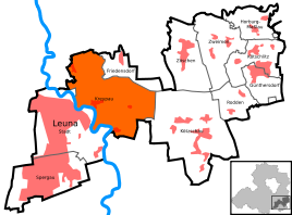
Location of Kreypau in Leuna
|
|
Kreypau is a district of the city of Leuna in the Saalekreis in Saxony-Anhalt (Germany). The villages Wölkau and Wüsteneutzsch belong to Kreypau.
geography
Kreypau lies between Leuna and Leipzig east of the Saale .
history
Kreypau was a small farming village, the population of which in the past centuries lived mainly from agriculture. The church was built in 1550/51, the tower in 1530; Remains of the previous Romanesque building are present. Another church is located in Wölkau.
Kreypau and its present-day districts of Wölkau and Wüsteneutzsch belonged to the Merseburg district of Merseburg until 1815 , which had been under Electoral Saxon sovereignty since 1561 and belonged to the secondary school principality of Saxony-Merseburg between 1656/57 and 1738 . The decisions of the Congress of Vienna the places came in 1815 to Prussia and were 1,816 Merseburg in the administrative district of Merseburg of the Province of Saxony allocated.
In 1870 the Saale near Kreypau was straightened, the former river bend encloses a small alluvial forest. In 1871, as in many other German cities and communities after the Franco-Prussian War , a so-called "Peace Oak" was planted in Kreypau . On October 3, 1990, the day of the reunification of Germany , oaks were also planted in the neighboring villages.
On July 1, 1950, Trebnitz, Wölkau and Wüsteneutzsch were incorporated into Kreypau.
From 2006 to 2009 Kreypau was part of the Leuna-Kötzschau administrative community . Until December 30, 2009 Kreypau was an independent municipality with the associated districts of Kreypau, Wüsteneutzsch and Wölkau; until 2003, Trebnitz, now part of Merseburg, also belonged to it. The last mayor was Peter Engel. On December 31, 2009, Kreypau was incorporated into the city of Leuna .
coat of arms
Blazon : "In gold, four green oak leaves in quatrefoil, including a green fallen acorn." It was a decision of the Kreypau community, which was included in the seal of two of the above mentioned as early as the beginning of the 20th century. Community-run oak symbolically to be included in the newly created coat of arms. Following on from the four districts, four oak leaves were chosen, under which an acorn was placed.
The coat of arms was designed in 1999 by the Magdeburg municipal heraldist Jörg Mantzsch .
Transport links
The federal highway 181 runs from Merseburg to Leipzig north of Kreypau . The PNVG bus lines also operate there . Line 737 serves the section between Merseburg , Bad Dürrenberg and Günthersdorf , while bus line 742 connects the cities of Merseburg, Bad Dürrenberg and Lützen .
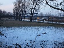
The next bridges for cars across the Saale are in Merseburg and Bad Dürrenberg. There used to be a ferry from Kreypau to Leuna. Pedestrians and cyclists can use the railway bridge of the former Merseburg – Leipzig railway line (traffic stopped in 1998) to cross the Saale.
The Saale-Elster Canal was supposed to flow into the Saale near Kreypau, construction was stopped in 1943. The lock in Wüsteneutzsch is a striking investment ruin. Should it happen that the canal is still being built, a ship lift is planned instead of the lock ruins.
Building for the Saale-Elster Canal in Kreypau, in the background Leuna on the other bank of the Saale
See also
Individual evidence
- ^ Karlheinz Blaschke , Uwe Ulrich Jäschke : Kursächsischer Ämteratlas , Leipzig 2009, ISBN 978-3-937386-14-0 , p. 84 f.
- ^ The district of Merseburg in the municipal directory 1900
- ↑ Kreypau and its districts on gov.genealogy.net
- ↑ StBA: Area changes from January 2nd to December 31st, 2009
- ↑ https://www.youtube.com/watch?v=s9wJ14ciZ3Y


