
Roßplatz
| Roßplatz | |
|---|---|
|
|
|
 Roßplatz - seen from the west (2016) |
|
| Basic data | |
| place | Leipzig |
| District | Center-South, -Southeast |
| Created | 17th century |
| Newly designed | 1950s |
| Confluent streets |
Augustusplatz , Martin-Luther-Ring, Goldschmidtstraße, Grünewaldstraße, Universitätsstraße, Markthallenstraße, Brüderstraße |
| Buildings | Ring development with ring café , former bowling club |
| use | |
| User groups | Car traffic , public transport , foot traffic |
| Technical specifications | |
| Square area | approx. 5.2 ha |


The Roßplatz in Leipzig is the southeastern part of the inner city ring running around the city center with two-lane directional lanes and a separate track. With the four-lane expansion of the ring and emerged in the 1950s and adapted the road ring development of Roßplatz his former character has lost a place to some extent.
location
Roßplatz begins at the southeast corner of Augustusplatz , then swings in an arc from south to west and ends after 460 meters at the northeast corner of Wilhelm-Leuschner-Platz (until 1945 Königsplatz). This point is within the Wilhelm-Leuschner-Platz tram stop and not, as is often assumed because of the lack of development on the south side since the Second World War , on the corner of Grünewaldstrasse.
Goldschmidtstraße (until 1947 Königstraße), Grünewaldstraße (until 1950 Kurprinzstraße, until 1880 Schrötergässchen) and Universitätsstraße flow into Roßplatz. The Auguste-Schmidt-Straße (formerly Roßstraße), Seeburgstraße and Sternwartenstraße end behind the development. In the inside of the arch of the Roßplatz, which was never built on, is the Lenné facility (unofficially also Schillerpark).
According to the small-scale division of Leipzig from 1992, the border between the districts center, center-southeast (with the ring development) and center-south runs across Roßplatz .
history
The origins of the Roßplatz in the unsuccessful siege of Leipzig by troops of the 1,547 Schmalkaldic League under Johann Friedrich I. in the Schmalkaldic War , when the previously almost to the walls approach reaching suburbs were burned down. After this siege, the defenses were redesigned by building bastions , here the Moritzbastei , and the area in front of it was left undeveloped as a free field of fire ( glacis ).
In 1625, Elector Johann Georg I granted the city of Leipzig the privilege of holding a horse market twice a year. The open area in front of the Moritzbastei was chosen as the place for this, which was also called Kautz, the Slavic word for gravel , because of the nearby gravel pits . From then on, the name Roßmarkt or Roßplatz became increasingly popular. 1681 were in the presence of Elector Johann Georg III. the first Leipzig horse races were held here.

Since the city wall increasingly lost its military significance in the last quarter of the 17th century, the area in front of the city fortifications was gradually released for building. First of all, the Bose Baroque Garden was created adjacent to the territory , the model for numerous other gardens around the city. Houses were also built on the south side of the Roßmarkt, but always leaving the large square free. Initially they were simple buildings, mostly with a garden at the back, but over the years some of them were dismantled and enlarged, until such representative buildings as the Panorama and the Café Bauer were built at the end of the 19th century .
On August 12, 1845, after protests against the Saxon Prince Johann in front of the Hotel de Prusse, firearms were used against the protesters on the Roßplatz , and eight citizens were shot. These processes are also known as the "Leipzig slaughter" .
In 1857, on behalf of the city council , Peter Joseph Lenné removed the trees that had previously been in a strict row along the northern boundary of the square and designed an English-style park with clusters of meadows and curved paths, the Schillerpark , taking into account the filled-in moat and the backfill of a hill . In 1872 the first horse-drawn tram drove around the center ring and thus also across Roßplatz. In 1883 the branch to the Bavarian train station followed through Kurprinzstraße, to which Schrötergässchen had been extended, and in 1896 electrification.
The bombing raid on Leipzig on December 4, 1943 destroyed the entire development of the Roßplatz. After the ruins had been dismantled, the foundation stone for the new ring development, which was completed in 1955, was laid on the eastern part of Roßplatz on August 29, 1953. The western part of the square has remained undeveloped from 1987 until today, with the exception of the now vacant bowling club .
Development
Historical development
In the historical building that was destroyed in 1943, house numbering began on the western side, unlike today, and, as it is today, contained both odd and even numbers due to the lack of the opposite side.
- No. 1: The hotel “Zumgrün Baum” was on the corner of Roßplatz and Königsplatz and dates back to a break from the 18th century. It was demolished in 1894 and rebuilt with four floors.
- No. 2–4: No. 2, since 1875 "Darmstädter Hof", and the following houses around Markthallenstrasse (previously Kleine Windmühlgasse) fell victim to the building of the Central Market Hall, which opened in 1891 , so that the view from Roßplatz to the market hall was unobstructed .
- No. 3b: Wigandsche Druckerei , where the German first edition of Karl Marx 's “ Das Kapital ” was printed in 1867 . A memorial plaque on Roßplatz No. 13, near the former location of the printing works, reminds of this.
- No. 5: Moving north towards the front of numbers 1–4 (roughly at the location of the later bowling club), the Panorama was created in 1883/84, a round building with a partially glazed dome for the display of panorama images, in particular of German-French battles War 1870/71 . From 1927 onwards, so-called “artist games” took place in the upper hall, in which windows were now installed, instead of the circular painting show, while the ground floor was occupied by one of Leipzig's largest restaurants. Before the Panorama was built, the council chamber courtyard was located here in the 18th century and belonged to the building director Johann Carl Friedrich Dauthe from 1798 to 1814 and then to the councilor and council builder Carl Friedrich Gerhard Gruner.
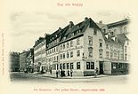
The "Green Tree" before 1894
The new "green tree"
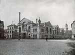
The market hall from Roßplatz
The Gruner house

The panorama around 1910


- No. 5b: Also on the site of the former Gruner house, the Society House of the Harmonie Society was built in 1887 according to plans by Arwed Roßbach .
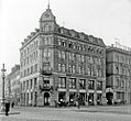
- No. 6: In 1889 the representative Café Bauer was built on the site of an older previous courtyard . After the café was closed, the Leipzig branch of the Girozentrale of the Saxon Community Association resided here, and elegant apartments were built on the upper floors. From 1912 the building complex also contained a cinema.
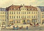
- No. 7: In 1717 an inn “Zum Helm” (also Open Helmet and Golden Helmet) was opened here. Because of an earlier stay of the Prussian queen widow , it was allowed to call itself "Hôtel de Prusse" from 1805. The house was rebuilt from 1881 to 1883 and from 1905 was called the “Preußischer Hof”. In 1921 the hotel ceased operations.

The "Harmonie" society house in 1887

Café Bauer, “Harmonie” society center and Panorama

At Café Bauer

Hotel de Prusse around 1880

The Prussian Court around 1917


- No. 8: In 1709, the horse trader Johann Schröter built an inn on his large property on Roßplatz, which stretched as far as Windmühlenstraße, which he named "Zum Churprinz" in honor of the then Saxon electoral prince . Behind it were courtyards and gardens belonging to the property. In 1750 the inn became a stately home, which was bought by the Polish prince Józef Aleksander Jabłonowski in 1773 . From 1799 on, the property was owned by the Leplay family until the real estate company bought it and parceled it out in 1879. Schrötergäßchen was expanded to become Kurprinzstraße and a new corner house was built on the site of the old Elector Prince, but it kept the name Kurprinz in the vernacular.
- No. 10: The “Zur Wartburg” inn has had this name since 1891. Before it was called “Walhalla”.
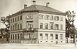
- No. 11: The Saxon state bought this building in 1810 and used it as a post office until 1876 . In 1877 the administration of the Leipzig district administration moved in here. The next two buildings on the square flanked Roßplatz, but were on both sides of the confluent Roßstrasse, to which they belonged. It was the "Hauffe" and "Hentschel" hotels.
House "Zum Kurprinz" around 1880, Schrötergäßchen on the right

The Kurprinzstraße around 1900, on the left the "new Kurprinz"
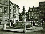
Hotel Wartburg with the Mägdebrunnen
House of the District Headquarters
North-east side with Hotel Hauffe and district main team


Current development


The development in the ring from 1955 is a typical example of GDR architecture in the style of socialist classicism , also known as the “ confectioner's style ”. The complex consists of a total of fourteen seven- to nine-storey residential buildings with a curved floor plan at a distance of around 40 meters from the roadway of the inner city ring. The wide footpath is close to the house and is separated from the street by green spaces and a fountain installation. The plastered structure with partial travertine veneer and three-dimensional decorative elements contains 197 apartments. The ring café was built in the middle section . The foundation stone for the ring development was laid in August 1953. The design, which was finally favored after several competitions, came from the Rudolf Rohrer collective .
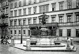
Part of the building is separated from the main building by Goldschmidtstrasse and is directly connected to the Europahaus . The Mägdebrunnen from 1906, which was previously located at the confluence of Seeburgstrasse and Sternwartenstrasse in Roßplatz, was set up here again.
In 1987 the bowling club was opened on the south side of the Roßplatz, which is located near the former panorama building. The building has not been used for years.
literature
- Horst Riedel: Stadtlexikon Leipzig from A to Z . PRO LEIPZIG, Leipzig 2005, ISBN 3-936508-03-8 . P. 511
- Ernst Müller: The house names of old Leipzig . (Writings of the Association for the History of Leipzig, Volume 15). Leipzig 1931, reprint Ferdinand Hirt 1990, ISBN 3-7470-0001-0
- Gina Klank, Gernot Griebsch: Lexicon of Leipzig street names , Verlag im Wissenschaftszentrum Leipzig, 1995, ISBN 3-930433-09-5
Individual evidence
- ^ Official city map of Leipzig , Office for Statistics and Elections Leipzig, 2007
- ↑ Leipzig Lexicon
- ^ Riedel: Stadtlexikon Leipzig from A to Z
- ^ Wolfgang Hocquél : Leipzig. Architecture from the Romanesque to the present . Passage-Verlag, Leipzig 2001, ISBN 3-932900-54-5 , pp. 138/139
- ↑ Thomas Topfstedt : The 50s. Socialist construction. In: Leipzig on foot. 22 city tours. Forum Verlag Leipzig, Leipzig / Hamburg 1990, ISBN 3-87975-543-4 , p. 163
Coordinates: 51 ° 20 ′ 7.8 ″ N , 12 ° 22 ′ 43.1 ″ E