Funny
Plaußig is a district in the northeast of Leipzig and a formerly independent municipality. The place has been a district of Leipzig since 1996 and, together with Portitz, forms the district of Plaußig-Portitz in the north-east district.
Location and local characteristics
Plaußig is about eight kilometers northeast of Leipzig city center. Its neighbors in the east are Taucha with its districts and, further clockwise, the Leipzig districts of Portitz, Thekla , Seehausen and Hohenheida .
The Parthe runs south of the village and flows through meadows and the remains of what was originally a larger alluvial forest . Parts of Plaußiger hall lie in the conservation area Partheaue-makers. To the east of the former village is the approximately one hectare village pond, which is used as fishing water. The Autobahn 14 in the south-west can be reached at the Leipzig-Messegelände driveway, three kilometers away. Plaussig is connected to the Leipzig public transport network via bus line 83 from Thekla.
To the north of the village, the BMW plant in Leipzig occupies 226 hectares of the Plaussig's 516 hectares. A further 30 hectares are allocated to an industrial park which is directly connected to the town to the north.
The place itself has retained its village character with three and four-sided courtyards. To the west, there is a residential area with homes. In the center of the former village are the former manor with its manor house, also known as the castle, and the baroque village church of St. Martin.
history
The settlement history of the Plaussiger Flur goes back almost 5000 years. Archaeological excavations have revealed evidence of a settlement in the Neolithic (2400–1800 BC), a settlement from the band ceramic culture, relics from the Young Bronze Age (1000 BC) and a Slavic village (1000 AD) . The first documented mention of the alley village comes from the year 1275.
The name of the settlement goes back to the Slavic pluskat ("splash"), which is probably a reference to the nearby Parthe. In 1339 the place was named as the manor house of Caspar Plusk and in 1490 it became the property of the Leipzig patrician family Thümmel. In 1551 about 170 people lived in Plaußig. Plaussig was badly affected during the Thirty Years' War . In 1656 the Sieber family from Leipzig became the owners of Plaußig. Council builder Johann Georg Sieber had the mansion, the parish and the church rebuilt from 1726 to 1742, as well as a school
During the Battle of Nations in October 1813, Plaussig, which was not part of the main battle area, was sacked by French troops. Until 1815, Plaußig was an exclave within the Leipzig District Office for the Electoral Saxon Office of Delitzsch . Since the Delitzsch office came to Prussia in 1815 through the resolutions of the Congress of Vienna , the Plaussig exclave was integrated into the royal Saxon district office of Leipzig surrounding the place.
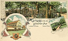
In 1859 a new school was built in the village, which was used until 1940. In 1868 a stone linden tree was planted next to the rectory , which has been a natural monument since 1999 . As a result of its proximity to Leipzig, Plaussig became a popular excursion destination for the city's population. The inn "Güldene Aue", which emerged from the village blacksmith's shop near the Parthe and operated from 1872 to 1982, became particularly famous.
The last owner of the Plaußiger Gut Otto Kabitzsch sold it in 1890 to the Johannishospital in Leipzig, which had it operated by tenants. Around 1910 the farm buildings were rebuilt between the manor house and Dorfstrasse.
After the end of the Second World War , the manor was not divided up in the course of the expropriation by the land reform, but converted into a national estate . The arable land was mainly used for growing seeds. In 1951 it was organizationally combined with the Abtnaundorf and Graßdorf estates . From 1973 it belonged to the KAP Leipzig-Nord, which was responsible for the cultivation of a field area of 4200 ha. Agricultural use continues to this day and has been operated by Saat-Gut Plaußig Voges KG since 1992, although large agricultural areas were lost due to the establishment of the industrial park (from 1993) and the construction of the BMW factory (from 2002).
On July 1, 1996, Plaußig was incorporated into Leipzig and combined with Portitz to form the Plaußig-Portitz district. An administrative court proceeding against the incorporation was unsuccessful.
literature
- Funny. A historical and urban study. Pro Leipzig e. V. (ed.). Leipzig 2001
- Vera Danzer, Andreas Dix: Leipzig - A regional history inventory in the Leipzig area . Ed .: Haik Thomas Porada . 1st edition. Böhlau, Cologne Weimar Vienna 2015, ISBN 978-3-412-22299-4 , pp. 258/260 .
- Horst Riedel, Thomas Nabert (ed.): Stadtlexikon Leipzig from A to Z . 1st edition. Pro Leipzig, Leipzig 2005, ISBN 3-936508-03-8 , pp. 469/470 .
- Cornelius Gurlitt : Pleasant. In: Descriptive representation of the older architectural and art monuments of the Kingdom of Saxony. 16. Issue: Amtshauptmannschaft Leipzig (Leipzig Land) . CC Meinhold, Dresden 1894, p. 95.
- Funny . In: August Schumann : Complete State, Post and Newspaper Lexicon of Saxony. 8th volume. Schumann, Zwickau 1821, p. 391.
Web links
- Plaussig in the digital historical place directory of Saxony
- Information website My district of the city of Leipzig for Plaußig-Portitz
Individual evidence
- ↑ Plaussig village pond. In: www.anglermap.de. Retrieved May 23, 2020 .
- ^ Karlheinz Blaschke , Uwe Ulrich Jäschke : Kursächsischer Ämteratlas. Leipzig 2009, ISBN 978-3-937386-14-0 ; P. 56 f.
- ↑ Plaussig in the Historical Directory of Saxony
- ^ Website of Saat-Gut Plaußig Voges KG - history
- ↑ StBA Area: changes from 01.01. until December 31, 1996
Coordinates: 51 ° 24 ' N , 12 ° 27' E


