New Harth
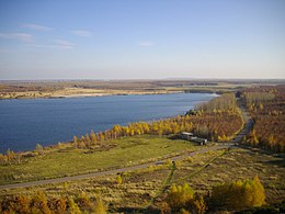
The Neue Harth is a mixed forest area newly reforested on a former mining waste site south of Markkleeberg in the Leipziger Neuseenland .
location
The Neue Harth lies in the districts of the cities of Leipzig , Markkleeberg, Zwenkau and Böhlen . It is bounded in the north by the town of Markkleeberg, in the east by Großstädteln and Gaschwitz (districts of Markkleeberg) and Großdeuben (district of Böhlen), in the south by Bundesstraße 2 and in the west by the Zwenkauer and Cospudener See . The area is cut in an east-west direction by the A 38 motorway .
A motorway exit from the A 38 (Leipzig-Neue Harth) is named after the Neue Harth in its western part near the Belantis amusement park .
history
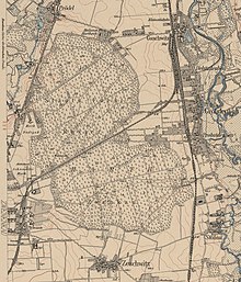
The Harth was previously a closed forest area on a slight elevation between the meadows of Weißer Elster and Pleiße with Zwenkau in the west and Großdeuben in the east. In addition to mixed forest, it also contained large parts of pure coniferous forest. The Harth was a popular excursion area for the people of Leipzig. The edge of the forest near Großdeuben and Gaschwitz was built on with villas. On the northern edge of the Harth was the Hartheck Sanatorium , a private and exclusive sanatorium and nursing home for the mentally ill owned by Dr. Wilhelm Sernau.
Until 1815, the Harth belonged as an exclave between the Electoral Saxon offices of Leipzig and Pegau to the Hochstift-Merseburgischen Amt Lützen , which had been under Electoral Saxon sovereignty since 1561 and belonged to the secondary school principality of Saxony-Merseburg between 1656/57 and 1738 . As a result of the resolutions of the Congress of Vienna , the western part of the Lützen district became part of Prussia in 1815. Harth, which remained with the eastern part of the Lützen office in the Kingdom of Saxony , was assigned to the Leipzig district office in 1815. In 1907 Die Harth was referred to as the "Zwenkau State Forestry District". Since 1875 it has belonged to the Leipzig administration .
In the years from around 1960 to 1970 the entire area of the Harth was dredged over by the Böhlen opencast mine (from 1969 opencast mine Zwenkau) coming from the south after the excavation of Zeschwitz (1943) . The Gaschwitz – Meuselwitz railway line , which had been closed in 1957, and the settlements belonging to Gaschwitz and Großdeuben were also dredged over . After the opencast mine was turned to the west at the beginning of the 1980s, the reforestation of new forest began on the eastern overburden field in GDR times.
Situation today
After the shutdown of the open-cast mine, reforestation was intensified, so that the Neue Harth again offers considerable opportunities for local recreation. The landscaping of the post-mining landscape is the responsibility of the Lausitzer und Mitteldeutsche Bergbau-Verwaltungsgesellschaft (LMBV). The Zweckverband Neue Harth , to which the neighboring communities belong, endeavors to develop tourism .
Circular paths have been laid out, which are signposted with information boards. Here, on the one hand, historical information is conveyed, on the other hand, information about the river network and the planned projects are provided. Hiking trails lead into the forest from Zöbigker , Großstädteln, Gaschwitz, Zwenkau and the Leipzig districts of Knautkleeberg , Knauthain and Hartmannsdorf . In snowy winters, cross-country skiing is possible on groomed trails. The Neue Harth is also home to rare plants such as St. John's wort and orchids.
By including the areas south of Zöbigker and between the lakes, which were previously fields, the area of the Neuen Harth is much larger than that of the earlier ones; the area covers about 535 hectares.
Since 2016, problems have increased due to an increase in groundwater and large parts of the mixed forest are dying off. The vegetation changes not only because the groundwater rises, but also because clay loam in the compacted soil prevents the surface water from running off. The mayor of the neighboring town of Markkleeberg had to find out that half of the approximately 15 hectares of mixed forest owned by the town are now dead, the other half is missing. The Lausitzer- und Mitteldeutsche Bergbauverwaltungsgesellschaft (LMBV) considers drainage to be unprofitable, so it is currently not clear what will happen next.
literature
- LMBV (Hrsg.): Book series Changes and Perspectives , Issue 04 Böhlen / Zwenkau / Cospuden , 2009, (online)
Web links
Individual evidence
- ^ Karlheinz Blaschke , Uwe Ulrich Jäschke : Kursächsischer Ämteratlas 1790 , Leipzig 2009, ISBN 978-3-937386-14-0 , p. 84 f.
- ↑ The Amtshauptmannschaft Leipzig in the municipal register 1900
- ↑ Drained: Over 33 hectares of forest in Neuer Harth are already dead. In: LVZ June 16, 2016. Retrieved on February 5, 2017 .
Coordinates: 51 ° 14 ′ 58.9 ″ N , 12 ° 21 ′ 16.6 ″ E


