
Gaschwitz
|
Gaschwitz
City of Markkleeberg
Coordinates: 51 ° 15 ′ 3 ″ N , 12 ° 22 ′ 48 ″ E
|
||
|---|---|---|
| Height : | 118 m | |
| Residents : | 671 (Apr 2009) | |
| Incorporation : | July 1, 1993 | |
| Postal code : | 04416 | |
| Area code : | 034299 | |
Location of Gaschwitz in Saxony |
||

Gaschwitz has been a district of the large district town of Markkleeberg in the Leipzig district in Saxony since July 1, 1993 . Before that it was an independent municipality south of Markkleeberg. The district of Kleinstädteln belongs to Gaschwitz.
location

Gaschwitz is located 10 km south of Leipzig on the Pleiße . The formerly scenic Pleißenaue and the wooded area west of Gaschwitz, the Harth , fell victim to lignite mining in the second half of the 20th century .
To the west of the Zwenkau opencast mine and to the east of the Espenhain opencast mine , the place lay on an approximately 500 m wide north-south "canal", which also includes the Leipzig-Altenburg railway line , the relocated long-distance road F2 / 95 and the relocated and straightened Pleiße had to. After the open-cast mine was closed, the overburden areas were recultivated, but the narrow north-south orientation of the infrastructure has remained. The neighboring towns of Gaschwitz are Großstädteln (also belonging to Markkleeberg) in the north and Großdeuben (to Böhlen ) in the south . The corridors of Großpösna (formerly Cröbern ) border in the east and those of Zwenkau in the west . In the vicinity of Gaschwitz are the Markkleeberger and the Cospudener See , which can be reached via a cycle path through the newly reforested Harth.
history
The beginnings
The name of Gaschwitz is of Sorbian origin. He is first mentioned in 1350 as Godiswicz. It can be assumed that with the settlement of the areas west of the Saale by West Slavic Sorbs, probably in the late 6th century, a settlement in the area of Gaschwitz also emerged. After 950, members of the Elbe Germanic tribes and later of Thuringians , Franks and Flemings immigrated . The area was probably Christianized by the Regensburg monk and later the first Merseburg bishop Boso .
The manor
Around 1390 Reinhold von Gaschwitz is mentioned as the feudal lord of a Gaschwitz moated castle. At the beginning of the 16th century, the manor or knight's seat of the 14th and 15th centuries was transformed into a manor, whose owners were the Erdmannsdorff and Pflugk families from 1506 to 1616 . In 1616 it was bought by Junker Jobst Brand von Lindenau and in 1694 by the von Zehmen family . At that time, the estate consisted of a baroque five-axis half-timbered house with a bay window and mansard roof, built around 1700. The von Zehmen family had the simple manor house built before they sold the estate to Friedrich von Hopffgarten , commander of the Pleißenburg in Leipzig in 1702 . In 1705 he built the manor house (old manor house) as a half-timbered house, but without a tower structure. The next owners from 1716 were Benjamin Magen, a lawyer from Leipzig, or his heirs. They built a new mansion next to the old one and laid out a park. The old mansion was modernized by the next owner, Mrs. Rahel von Bose , in 1759. Building on the mansard roof, a slate-covered, picturesque roof turret was attached, which sits enthroned as a clock tower and is equipped with a weather vane.

The new mansion around 1850 on one of the earlier ponds

The Dybwadsche new building of the new mansion from 1905


Other owners were the von Leyser and Astor families from 1761 to 1834. From 1834 to 1925 the Leipzig cathedral provost Dr. Friderici and his heirs, most recently the Plantier family, the estate. In 1876, three of the six ponds that had surrounded the estate up to that point were filled in as part of a ploy regulation. In 1905 the Plantiers had the new manor house built from scratch by the architect Peter Dybwad . In 1925 the Plantiers sold the estate to AG Sächsische Werke (ASW), which acquired land in preparation for lignite mining. Initially, the property and the land were leased to a Mr. Schreiber.
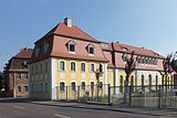
In 1945 the property was expropriated and converted into a state-owned property (VEG). The new mansion was separated from the estate and used as a school from 1947. Already in GDR times and afterwards the building structure of the property deteriorated to a great extent. In 2000 the city of Markkleeberg acquired the entire estate area. The renovation of the old mansion was followed by the restoration of the baroque orangery with the southern gatehouse from 2010 to 2012. Among other things, these rooms create the prerequisites for a re-emerging club life for the Markkleeberg districts of Gaschwitz and Großstädteln.

The old mansion before the renovation in 2013

The new mansion in 2009

The two gatehouses of the estate in 2006 before ...
... southern gatehouse and orangery after the restoration in 2012

The restored barn 2013


The place

In the Middle Ages , the village of Gaschwitz also developed through the influx of German settlers, but always depending on the manor, to which the neighboring Debitzdeuben also belonged. In 1598 Gaschwitz had 46 inhabitants. It suffered the usual plagues of history: around 1430 there were several incursions by the Hussites , Swedish troops besieged and looted it in the Thirty Years War, and 16 men were raised for Napoleon's Russian campaign in 1812. In the Battle of Nations in 1813 there was an outpost battle between the Russians and the French at the Gaschwitz Bridge. Gaschwitz was not spared from the plague either, in 1681 numerous residents died of it.
A church has not been built in Gaschwitz. The place was parish alternately to Großstädteln and Großdeuben and has belonged to the now united parish Großstädteln-Großdeuben since 2001. In 1895 the first school was established in Gaschwitz, albeit initially only one class. In 1910 Gaschwitz was connected to the public electrical power supply network, in 1920 to that of the water supply .


In the course of the 19th century, Gaschwitz developed into an attractive local recreation and residential area between Harthwald and Pleißenaue, particularly due to the railway connection. The sanatorium for the mentally ill "Hartheck" was opened on the Harth, and numerous villas were built on the road to Harth. Excursion restaurants such as the Central-Halle were built in the village, which was a popular dance restaurant and concert platform for blues music and the like until the second half of the 20th century. Gaschwitz and today's district of Kleinstädteln were located in the Electoral Saxon and Royal Saxon District Office of Leipzig until 1856 . From 1856 the places belonged to the court office of Zwenkau and from 1875 to the district administration of Leipzig .
In 1905, one of the first golf clubs in Germany was founded in Gaschwitz using the grounds made available by the manor as a golf course . In 1907 this was one of the founders of the German Golf Association (DGV) along with seven other golf clubs . It existed until 1945.
The expansion of the rail connections and the establishment of the marshalling yard brought a significant increase in population. In 1939, a third of the heads of households in Gaschwitz were employed by the Deutsche Reichsbahn . The lignite industry was the employer that led to further population growth. The company Weiß & Becker began underground mining of lignite in the north-western part of Gaschwitz in 1870, but this was discontinued for economic reasons. Only the opening of the large open cast mines Böhlen (1921) and Espenhain (1937) and the associated processing plants created numerous new jobs.
| year | 1834 | 1871 | 1890 | 1910 | 1925 | 1939 | 1946 | 1950 | 1964 | 1990 | 1997 | 2009 |
| Residents | 154 | 144 | 176 | 829 | 1273 | 1740 | 2106 | 2226 | 1975 | 1149 | 934 | 671 |
To protect the station, an anti-aircraft battery was stationed in 1943 , but it could not prevent it from receiving several bomb hits. A memorial stone in the local cemetery and graves of Soviet prisoners of war who fell victim to forced labor, as well as a grave site for four unknown concentration camp prisoners, who were probably thrown from a concentration camp transport train, commemorate the Second World War .
In 1964/65 the dredging of the western parts of Gaschwitz up to the railway line through the opencast mine Böhlen (renamed opencast Zwenkau in 1969) began. 767 inhabitants of this area had to be resettled. The eastern parts were dredged over by the Espenhain opencast mine at the same time. From 1958 to 1969, the Pleiße was straightened and relocated to the eastern edge of the town, and from 1971 to 1976 the F2 / F95 and the area were cleared for over-dredging by the Espenhain open-cast mine. Gaschwitz lost 70% of its land due to over-dredging.
On November 15, 1992, the citizens of Gaschwitz decided in a public vote in favor of incorporation into Markkleeberg. Since July 1, 1993, Gaschwitz and its small towns have been part of Markkleeberg.
traffic
In the past, rail traffic was of considerable importance in Gaschwitz. On the Leipzig-Altenburg railway line, which was opened in 1842 , Gaschwitz was given a railway stop in 1870 and at the same time was expanded to become an important freight shunting yard . In 1874 the Gaschwitz – Meuselwitz line was opened via Zwenkau and in 1879 that from Leipzig-Plagwitz . The Leipzig S-Bahn network was opened in 1969 and Gaschwitz was designated as the southern turning point of the heart-shaped ring line A.
The connection to Zwenkau was shut down and demolished in 1957 because of the advancing opencast mine. The route to Leipzig-Plagwitz has only been used as an occasional diversion route for freight or regional traffic since 2002. Of the original eight platforms at Gaschwitz train station, only two are currently in operation due to major renovations. These are served every half hour in both directions by the S-Bahn line S 6 of the S-Bahn Central Germany , alternating between the directions Geithain and Leipzig Messe . In addition, the station serves as the end point of the S 4 , which runs from Markkleeberg-Gaschwitz via Taucha , Torgau to Hoyerswerda .
The state road S 72 Markkleeberg- Rötha runs through Gaschwitz in a north-south direction . The four-lane federal road 2 runs outside the village, but beyond the Pleiße, so that due to the lack of bridges and driveways it can only be reached via Markkleeberg or Großdeuben. Since 2006, the A 38 motorway has been crossing the town in an east-west direction over a 455 m long bridge. The closest driveway is Leipzig-Süd on the B 2.
Gaschwitz can be reached by bike via the Pleiße cycle path Leipzig-Böhlen on a traffic-free and scenic route. At the end of May 2017, the Neuseenbrücke was also completed over the Bundesstrasse 2 and 95 , giving Gaschwitz a direct connection to Markkleeberger and Störmthaler See.

New station building in Markkleeberg-Gaschwitz

The highway bridge

Neuseenbrücke


_2017b.jpg)
Personalities
- Johann August Landvoigt (1715–1766), lawyer and flautist
- Otto Harrassowitz (1845–1920), antiquarian , publisher and author
- Karl Büchner (1910–1981), classical philologist who worked as a professor in Freiburg
- Jürgen Wieczorek (* 1948), former member of the German Bundestag ( SPD )
literature
- Saxony's church gallery . Volume: Inspections Leipzig and Grimma; Hermann Schmidt, Dresden 1837–1845
- In the Pleisse and Göselland between Markkleeberg, Rötha and Kitzscher. Published by PRO LEIPZIG eV, Leipzig 1999
- Cornelius Gurlitt : Gaschwitz. In: Descriptive representation of the older architectural and art monuments of the Kingdom of Saxony. 16. Issue: Amtshauptmannschaft Leipzig (Leipzig Land) . CC Meinhold, Dresden 1894, p. 19.
- Matthias Donath : Palaces in Leipzig and the surrounding area . edition Sächsische Zeitung Redaktions- und Verlagsgesellschaft Elbland mbH, Meißen 2013, p. 10, Gaschwitz p. 77.
- GA Poenicke: Album of the manors and castles in the Kingdom of Saxony , Volume 1: Leipziger Kreis, Leipzig 1860, Rittergut Gaschwitz, p. 61–62 (digitized)
Web links
- The Markkleeberg district of Gaschwitz
- Gaschwitz in the Digital Historical Directory of Saxony
- Gaschwitz . In: August Schumann : Complete State, Post and Newspaper Lexicon of Saxony. 3rd volume. Schumann, Zwickau 1816, p. 40 f.
- http://www.markkleeberg.de/de/kultur_tourismus/sehenswerte/architektur/gut_gaschwitz.html?print=true
- http: //www.sachsens-schlösser.de/index.php/22-m/1983-markkleeberg-altes-schloss-neues-herrenhaus-gaschwitz
Individual evidence
- ^ A b Digital Historical Directory of Saxony
- ^ Website of the city of Markkleeberg (accessed on July 5, 2012)
- ^ Karlheinz Blaschke , Uwe Ulrich Jäschke : Kursächsischer Ämteratlas. Leipzig 2009, ISBN 978-3-937386-14-0 ; P. 60 f.
- ↑ The Amtshauptmannschaft Leipzig in the municipal register 1900
- ↑ Information from the Markkleeberg residents' registration office in March 2009
- ↑ Area changes from January 1, 1993 to December 31, 1993. (PDF) (No longer available online.) Original at: statistik.sachsen.de , archived from the original on September 6, 2016 ; Retrieved July 25, 2017 .