
Markkleeberger See
| Markkleeberger See | ||
|---|---|---|

|
||
| Markkleeberger See | ||
| Geographical location | south of Leipzig | |
| Tributaries | Canoe park lock from Störmthaler See | |
| Drain | Small pleiße | |
| Places on the shore | Markkleeberg | |
| Data | ||
| Coordinates | 51 ° 16 '0 " N , 12 ° 24' 35" E | |
|
||
| Altitude above sea level | 113 m above sea level NN | |
| surface | 2.52 km² | |
| volume | 60,700,000 m³ | |
| scope | 7.8 km | |
| Maximum depth | 58 m | |
| Middle deep | 26 m | |
|
particularities |
||

|
||
| logo | ||

The Markkleeberger See is as mining landscape artificially incurred lake east of the eponymous city Markkleeberg south of Leipzig . Like the neighboring Störmthaler See , from which it is only separated by Autobahn 38 , it is part of a flooded open pit. With a depth of 57 or 58 meters, the Markkleeberger See is the deepest lake in the so-called Leipziger Neuseenland .
Flooding
It was created from July 20, 1999 to June 2006 when the northern part of the Espenhain open-cast lignite mine was flooded . Since July 15, 2006 the lake has been open to the public as bathing water and for boat traffic. The area of the lake is 252 ha, the storage space about 61 million cubic meters of water. The water level is 113 m above sea level. As a drain, the Kleine Pleiße connects the lake with the Pleiße .
The lake association of the Markkleeberger with the Störmthaler See over an 800 meter long canal was completed on May 18, 2013. A lock with a four-meter lift was built here, as the lakes will have different water level heights. The canal has a bridge with a clearance of 9.48 meters, so that sailing boats can pass through.
Between November 2017 and June 2018, a 618-meter-long, erosion-proof trench with cascades to overcome a 29-meter difference in height was built, which enables the Auenhain trench to be opened in an open manner. This drains the areas east of the lake.
Road network
Since its completion in 2009, it has been possible to circumnavigate the lake at various heights on an extensive network of paths - close to the water on the "Unteren Uferweg" and above on the Uferrundweg (length 9.2 km) and its numerous scenic side paths.
Facilities
- Lake promenade: A paved lake promenade runs along the north bank, which can be used as a starting point to explore the Leipziger Neuseenland. Parking spaces for cars have also been created here and catering facilities have been established. Since September 2012 ship tours with two passenger ships have started here. The first ship was named " MS Wachau " on October 8, 2012 . Its route, which has been extended to include the canoe park lock to Störmthaler See since 2013, can be used for regular or round trips. The second ship, the MS Markkleeberg , offers hourly tours on Lake Markkleeberg.
- Jetty, surfing beach, sailing base
- Beaches: Along the northeast embankment between the lake promenade in Markkleeberg Ost and the Auenhainer Bucht there are bathing beaches of different quality levels: Family beach on the lake promenade, green beach bays on the Wachau beach, Auenhainer sports beach and dog beach
- Canoe Park Markkleeberg : Canoeing and whitewater facility with two independent stretches of 130 and 270 meters in length, primarily for top-level canoeing , but also for recreational sports
- Seepark Auenhain: Above the Markkleeberger See is the holiday village Seepark Auenhain with 38 holiday homes, a restaurant, a wellness and beauty house and a children's house.
- Auenhain model building park
- Markkleeberg climbing park
- Auenhainer Bucht water sports station
- Boat rental lake promenade
- Adventure rest area and playground on the lake promenade
- Island: The so-called " Getzelauer Insel", located in front of the south beach of the lake, is part of a priority area for nature and landscape, which includes a large area south of the lake.
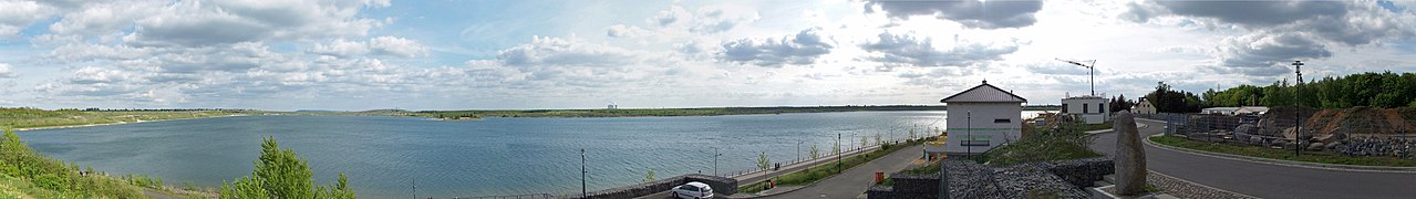
Markkleeberger See from the north bank

See also
- Central German Lakeland with Leipzig New Lakeland
- List of bodies of water in Saxony
literature
- Lutz Schiffer et al. (Ed.): Mining residual lakes in Central Germany. Nautical compass. Chemnitz / Espenhain 2002.
Web links
Legal basis
- Ordinance of the district of Leipzig regulating the scope of public use for the Markkleeberger See from 2007.
- General decree of the Leipzig district on the Markkleeberger See (PDF; 1.2 MB) “Driving with small vehicles with electric motors and diving with technical aids” from 2011.
Further information
- Markkleeberger See
- Water depths and topographical profile of the Markkleeberger See
- Seenkompass - Markkleeberger See ( Memento from February 23, 2015 in the Internet Archive )
- Map post-mining landscape Markkleeberger See - final state ( Memento from September 28, 2007 in the Internet Archive )
Individual evidence
- ^ Leipziger Neuseenland: Sluice opened between Markkleeberger and Störmthaler See. In: Leipziger Volkszeitung. May 18, 2013, accessed November 8, 2018 .
- ↑ Ralf Julke: Rainwater from the eastern edge of the Markkleeberger See now has a decent ditch drain again. In: Leipziger Internet Zeitung. July 1, 2018, accessed November 8, 2018 .
- ↑ LVZ of October 9, 2012, p. 21
- ↑ Shipping on the Markkleeberger and Störmthaler See. City of Markkleeberg, accessed November 8, 2018 .