
Störmthaler See
| Störmthaler See | ||
|---|---|---|

|
||
| The Störmthaler See 2008. View to the north | ||
| Geographical location | 12 km south-southeast of Leipzig | |
| Tributaries | Schlumper , old gosel | |
| Drain | Canoe park lock to the Markkleeberger See | |
| Data | ||
| Coordinates | 51 ° 14 '11 " N , 12 ° 26' 50" E | |
|
||
| Altitude above sea level | 117 m | |
| surface | 7.33 km² | |
| volume | 0.158 km³ | |
| scope | 20 km | |
| Maximum depth | 55 m | |
|
particularities |
Open pit mine, data apply at the end of the flooding |
|


The Störmthaler See is an artificial lake south of Leipzig . It was created by flooding the southeastern part of the former Espenhain open-cast lignite mine . The Markkleeberger See is directly adjacent , it is only separated by the Autobahn 38 .
Flooding
The lake has been filling naturally since January 1, 2001, but the controlled flooding did not begin until September 13, 2003. In March 2004, according to the Lausitzer und Mitteldeutsche Bergbau-Verwaltungsgesellschaft (LMBV), the water level was 89 m above sea level. NHN (19%) and in October 2010 a water level of 114 m above sea level. Reached NHN . In mid-September 2012, 40 centimeters were missing to the final water level of 117 m above sea level. NHN . When a dam broke near Oelzschau on June 3, 2013, the flood-leading Gösel flowed into the Störmthaler See in the Old Bed. Up to June 8, 2013, up to 3 m³ / s of water flowed into the lake, causing it to rise above the planned final water level. The water level could be normalized again via the new canoe park lock.
Swamp water from the active opencast mines Profen and Vereinigte Schleenhain was used for flooding . According to the experts, the final water level would not have been reached until 2075 without this extraneous water.
On April 27, 2014, designated areas of the lake were released as bathing water.
Leipzig New Lakeland
A lake landscape has been emerging as a post-mining landscape south of Leipzig for several years. The Cospudener See in the west is the oldest, the Markkleeberger See with its depth of approx. 57 meters is the deepest lake in the so-called Leipziger Neuseenland .
There are plans to connect the lakes with rivers and canals. Since May 2013 there has been a connection between the Markkleeberger and the Störmthaler See. A lock was built here for shipping because the Störmthaler See has a water level four meters higher. The canal has a bridge with a clearance of 9.4 meters, so that even medium-sized sailing boats can pass through. However, the Störmthaler See is not yet allowed to be used by private boats without a special permit.


Facilities
- Art installation Vineta - a floating island in the lake, which is supposed to be reminiscent of the church of the excavated town of Magdeborn .
- The butterfly is a planting on the south bank of the lake, which is supposed to change colors depending on the vegetation periods of the different plants.
- The Highfield Festival, previously located at the Hohenfelden reservoir near Erfurt, has been taking place on the Magdeborn peninsula since 2010.
- In June 2014, the Lagovida holiday resort was opened on the south bank with a hotel, a marina, holiday homes and a mobile home space. The dune houses are said to have a certain relationship with Hobbiton .
- Mining Technology Park on the northwest bank
- Geological time trail with 15 steles
- Lock and canal connection to Lake Markkleeberger See (opening on May 18, 2013)
- Tours with an amphibious vehicle that is unique in Germany are offered on the lake .
- Göhrener Insel nature reserve

Vineta

Lagovida dune houses

Göhrener Island
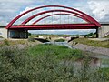
Canal between Störmthaler and Markkleeberger See


See also
literature
- Lutz Schiffer (Ed.): Mining residual lakes in Central Germany. Nautical compass . Chemnitz / Espenhain 2002.
Individual evidence
- ^ Dpa: Sailing boats on the Störmthaler See despite the wobbling clearance. In: Leipziger Volkszeitung. September 18, 2012, accessed November 8, 2018 .
- ↑ In Grunaer Bucht, the consequences of flooding caused erosion in the embankment area. News of the LMBV, June 11, 2013, on: lmbv.de, accessed on June 25, 2013
- ↑ Jörg ter Vehn: Opening of the Störmthaler See: With wet feet and small swipes. In: Leipziger Volkszeitung. April 28, 2014, accessed December 10, 2015 .
- ↑ Jörg ter Vehn: Leipziger Neuseenland: Lock between Markkleeberger and Störmthaler See opened. In: Leipziger Volkszeitung. May 18, 2013, accessed December 10, 2015 .
- ↑ Butterfly. (No longer available online.) Grosspoesna.de, archived from the original on December 21, 2015 ; Retrieved December 9, 2015 .
- ^ Südthüringer Zeitung: Highfield Festival moves to Saxony. November 5, 2009, archived from the original on November 9, 2009 ; Retrieved April 27, 2013 .
- ↑ Leipziger Volkszeitung: Amphibious vehicle on Störmthaler See has water again under the Kiel. May 18, 2011, accessed April 27, 2013 .
Web links
- www.stoermthaler-see.info (website of the community Großpösna to the Störmthaler See)
- Post-mining landscape of the Espenhain opencast mine (approx. 7 MB; PDF)