
Gösel
|
Gösel Geisel (obsolete), Göselbach |
||
 The Gösel at Oelzschau |
||
| Data | ||
| location | Germany , Saxony , District of Leipzig | |
| River system | Elbe | |
| Drain over | Pleiße → Weisse Elster → Saale → Elbe → North Sea | |
| source | Stockheim (to Bad Lausick ) 51 ° 11 ′ 8 ″ N , 12 ° 35 ′ 24 ″ E |
|
| Source height | 161 m | |
| muzzle |
Pleisse bei Rötha Coordinates: 51 ° 12 ′ 19 ″ N , 12 ° 23 ′ 53 ″ E 51 ° 12 ′ 19 ″ N , 12 ° 23 ′ 53 ″ E |
|
| Mouth height | 125 m | |
| Height difference | 36 m | |
| Bottom slope | 1.7 ‰ | |
| length | 21.5 km | |
| Catchment area | 50 km² | |
| Left tributaries | Oberholzgraben | |
| Right tributaries | Marrow ditch, Fipper | |
The Gösel (also Göselbach, formerly also Geisel) is a right tributary of the Pleiße in the Leipzig district in Saxony . It has a length of 21.5 kilometers (originally about 25 kilometers).
course
The Gösel begins in Stockheim ( near Bad Lausick ). The source is difficult to make out because the corridor drainage is integrated into the brook, which is a little wider behind the church, to the southwest of the village. After an arc to the east (Großbuch) and north ( Otterwisch ), the Gösel takes a westerly direction, which it maintains until it flows into the Pleiße near Rötha .
Until the 1960s, it turned north-west after Pötzschau , in order to reach the Pleiße after passing Dreiskau-Muckern and the districts of Magdeborn and Cröbern near Markkleeberg -Ost. Because of the advancing lignite mining ( Espenhain open-cast mine ), its course from Pötzschau had to be relocated, so that from then on it covers over 8 kilometers in an artificially constructed river bed to its new mouth, 4.5 kilometers of which over partially recultivated land of the former open-cast mine .
Shortly before the estuary, the Gösel wets the surrounding fields in the area of the federal highway 95 with smoke water . The annually growing area is several hectares and includes the sub-areas south and north of the Gösel and east and west of the federal highway. The crossing under the latter by a village road is not yet usable again, as it is also located in the flooded area. The city of Rötha will upgrade the road by mid-2018.
Old Gösel
Today the Alte Gösel drains the floodplain from Pötzschau mostly underground and only emerges from the water-bearing layers a few hundred meters before it flows into the Störmthaler See . There, because of the much lower lake level, she cut several meters into her old valley and raised an alluvial fan in the Gruna Bay.
- Change in the course of the river
In 2010, after prolonged rainfall due to widespread flooding, the dam was opened near Dreiskau-Muckern, which was built to protect the open-cast mine from the water of the Alte Gösel. Since then, the Alte Gösel has been flowing continuously in the old bed, at least after heavy rain events. The steep banks of the incised Alte Gösel, which were in danger of collapsing, were removed in the summer of 2011 despite the settlement by the strictly protected sand martins . The alluvial fan that had been created up to that point was inundated by the continuous flooding of Lake Störmthal.

When a dam broke near Oelzschau on June 3, 2013, the flood-leading Gösel flowed into the Störmthaler See in the old bed and carried nutrients, seeds and rubbish into the floodplain. Up to June 8, 2013, up to 3 m³ / s of water flowed into the lake, causing it to rise above the planned final water level. The artificially modeled banks of the Gösel were eroded again and raised as a new alluvial fan above the lake level.
The newly created steep banks were immediately populated again by sand martins and the new softwood floodplain, including alluvial fans , was planted with willows , alders and poplars , as well as numerous grasses and shrubs . The Alte Gösel meanders between the steep banks and branches off several times near the mouth. The estuary delta in particular is criss-crossed by numerous tributaries and tributaries. The changing flow and the change in vegetation determine which arms are flowed through. Motorcyclists and quad riders initially disturbed the young biotope, but after a few years were prevented from driving by the dense branches of the young alluvial forest .
At the end of 2019, the Großpösna municipal council decided to clear the Gruna Bay sediment. The earth masses of the alluvial fan are to be taken out of the fairway. It will only be clear after the proposed solutions and preliminary investigations whether this will actually only “strengthen” a fairway or whether the entire sediment of the Gösel will be removed and the delta including the alluvial forest destroyed.
Tributaries
- Markgraben and Fipper near Kömmlitz (left)
- Oberholzgraben (right, not always water-bearing)
before laying
- Schlumper in Magdeborn (right)
Water quality
As the Gösel was used as a receiving waterway to discharge polluted wastewater from the Espenhain combine that processed lignite , which entered the Gösel via the so-called tar ditch near Pötzschau, the water quality in the lower reaches of the brook was very poor from the 1940s onwards. In the last full year of operation in 1989 alone, 34.7 million cubic meters of wastewater were discharged, which contained 1,560 tons of suspendable particles, 580 tons of ammonium , 403 tons of extractables and 2.5 tons of hydrogen sulfide . Over the decades, this had led to the ecological desolation of the brook, which had become a sewer, according to the GDR water quality classification, class 6 (water poisoned, unusable). When the plant was shut down at the beginning of the 1990s, the water quality improved significantly. In 2001, according to the current classification, Class II-III was reached.
Places on the Gösel
The Gösel area is a very old settlement area. There were numerous mills (marked with M at the places) that drove the Gösel over mill ditches or reservoirs. The places on the Gösel are often referred to as the Gösel villages.
- Stockheim (to Bad Lausick )
- Capital (to Otterwisch)
- Otterwisch (M)
- Rohrbach (to Belgershain) (M)
- Oelzschau (to Espenhain) (M)
- Kommlitz (to Espenhain)
- Pötzschau (with Großpötzschau (M), Kleinpötzschau and Dahlitzsch (M), to Espenhain)
before the river was relocated
- Dreiskau-Muckern (M)
- Magdeborn (with Göltzschen, Gruna, Tanzberg, Dechwitz, Göhren, Sestewitz (M))
- Crawling
- Crostewitz (from 1923 to Cröbern)
(M) = former mill
Pictures of the Gösel

Hall drainage near Stockheim

The young Gösel behind the Stockheim church
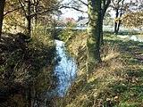
The Gösel next to the Oelzschauer ponds

Typical Göselflur between Oelzschau and Pötzschau

The Gösel in the new river bed near Pötzschau

Pötzschau in the wide valley of the Gösel

The Gösel in the former mining area

The mouth of the Alte Gösel in the Störmthaler See, June 2013

The mouth of the Alte Gösel in August 2014


literature
- In the Pleisse and Göselland between Markkleeberg, Rötha and Kitzscher - published by PRO LEIPZIG eV, Leipzig 1999
- Leopold von Zedlitz-Neukirch: New hydrographic lexicon for the German states . Halle 1833, p. 143 (digitized version)
- Miles & measurement table sheets & equidistant map of Saxony (1780-1942) On: deutschefotothek.de
Individual evidence
- ↑ Model project for spatial planning (MORO) "Spatial development strategies for climate change" Regional Planning Association Leipzig Westsachsen, Dresden, March 2010, on: klimamoro.de (pdf; 4.4 MB)
- ↑ [1] Article of the LVZ from August 20, 2017; On: lvz.de; last accessed: August 27, 2017
- ↑ a b In Grunaer Bucht, the consequences of floods caused erosion in the embankment area
- ↑ Green light for the road to the lake, beach preparation and lifeguard tower , article by LVZ, November 28, 2019, on: lvz.de
- ^ Sächsisches Landesamt für Umwelt und Geologie (LfUG) (Ed.): Der Braunkohlenbergbau im Südraum Leipzig , 2004 (digitized) ( Memento of the original from December 4, 2015 in the Internet Archive ) Info: The archive link was automatically inserted and not yet checked. Please check the original and archive link according to the instructions and then remove this notice.
Web links
- as gößel . In: August Schumann : Complete State, Post and Newspaper Lexicon of Saxony. 3rd volume. Schumann, Zwickau 1816, p. 240.
- Private website for Magdeborn
- Cröbern / Crostewitz on the Markkleeberg website
- Espenhain opencast mine