
Schlumper Bach
|
Schlumper-Bach Schlumper |
||
 The Schlumper-Bach on a map from 1907 |
||
| Data | ||
| location | Germany , Saxony , District of Leipzig | |
| Drain over | Störmthaler See → Canoe Park Lock → Markkleeberger See → Kleine Pleiße (Markkleeberg) → Pleiße → White Elster → Saale → Elbe → North Sea | |
| source |
Oberholz 51 ° 14 ′ 46 ″ N , 12 ° 30 ′ 12 ″ E |
|
| Source height | 153 m | |
| muzzle |
Störmthaler See Coordinates: 51 ° 14 ′ 25 ″ N , 12 ° 28 ′ 25 ″ E 51 ° 14 ′ 25 ″ N , 12 ° 28 ′ 25 ″ E |
|
| Mouth height | 117 m | |
| Height difference | 36 m | |
| Bottom slope | 16 ‰ | |
| length | 2.3 km | |
The Schlumper Bach (sometimes just the Schlumper ) is a 2.3 kilometer long brook in the Leipzig district in Saxony and a tributary of the Störmthal lake .
course
The Schlumper brook rises on the western edge of the Oberholz , located southeast of Leipzig , and then flows west towards Störmthal . At the part of Störmthal, which is commonly referred to as sheep farm, he reaches the sheep farm. At the outlet from the pond, he crosses under the district road K7925.
Until the 1980s it flowed, touching the castle park of Störmthal, then again through a pond in the Rödgen district of Störmthal . From here it crossed a wide meadow valley, before flowing into the Gösel between the Magdeborn districts of Göltzschen and Gruna .
The Gösel had already been interrupted in its old run to the Pleiße in the 1960s by the Espenhain opencast mine . Therefore, a newly created tributary to the relocated Gösel to Pötzschau was necessary. When the lower reaches of the Schlumper brook fell victim to the opencast mine in the 1980s, it was integrated into the open pit drainage on the edge of the open pit south of Störmthal.
When the open-cast mine was closed in the first half of the 1990s, it was no longer drained, and the remaining hole was flooded to the Störmthal lake . The water from the Schlumper brook was fed into the lake via a pipeline about 500 meters long. This began about 300 meters below the shepherd's pond with an inlet structure at a small pond.
In the design of the northeast bank of the Störmthaler See, an open course of the Schlumper brook is again provided, whereby the overcoming of the height difference on the steep bank of over 35 meters takes place over a short distance in two cascades with five steps each. The construction work began in October 2017 and was completed at the end of 2018.
A left tributary of the Schnauder , which flows southeast of Groitzsch into the Schnaudermühlgraben, is also called Schlumperbach.

The valley of the Schlumper brook between the Oberholz and Störmthal. The brook runs along the wooded border
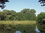
The shepherd's pond in Störmthal, on the right the inlet of the Schlumper brook

The feeding of the Schlumper-Bach by pipeline into the Störmthaler See


Individual evidence
- ↑ Jörg ter Vehn: Schlumperbach comes out big: Cascade in Störmthaler See under construction. In: Leipziger Volkszeitung. October 11, 2017, accessed November 8, 2018 .
- ↑ Olaf Barth: Schlumperbach soon falls into Störmthaler See. In: Leipziger Volkszeitung. June 29, 2018. Retrieved November 8, 2018 .
- ^ Topographic map (measuring table sheets) Saxony, 1942, sheet 41 Section Pegau, State and University Library Dresden, Inv.-No .: SLUB / KS 24043
Web links
- Dresden SLUB: Topographic map of Saxony 1: 25000 (measuring table sheets), sheet 26, Liebertwolkwitz on: deutschefotothek.de