
Groitzsch
| coat of arms | Germany map | |
|---|---|---|

|
Coordinates: 51 ° 9 ′ N , 12 ° 17 ′ E |
|
| Basic data | ||
| State : | Saxony | |
| County : | Leipzig | |
| Height : | 152 m above sea level NHN | |
| Area : | 70.17 km 2 | |
| Residents: | 7586 (Dec. 31, 2019) | |
| Population density : | 108 inhabitants per km 2 | |
| Postal code : | 04539 | |
| Primaries : | 034296, 034492 (Berndorf) | |
| License plate : | L , BNA, GHA, GRM, MTL, WUR | |
| Community key : | 14 7 29 170 | |
| City structure: | 29 districts | |
City administration address : |
Markt 1 04539 Groitzsch |
|
| Website : | ||
| Mayor : | Maik Kunze ( CDU ) | |
| Location of the city of Groitzsch in the Leipzig district | ||
  |
||

Groitzsch is a small town in the Leipzig district in Saxony . The intensive colonization of Saxony began in the early 12th century under Wiprecht von Groitzsch . The oldest known stone buildings in Saxony can be found at Groitzsch Castle .
geography

Geographical location
Groitzsch is located 25 km south of Leipzig and 20 km northeast of Zeitz in the triangle of Saxony , Thuringia and Saxony-Anhalt . The city is located on the edge of the Leipzig lowland bay in the White Elster - and Schnauderaue south of the confluence of the Schwennigke and the Schnauder . The area is characterized by the flat landscapes that are predominant in the North German Plain . Here the plain gradually changes to the low mountain range threshold, which can be seen in the slight hills throughout the city. The area around Groitzsch is particularly dominated by agriculture around the districts , very large fields and meadows dominate this area. There are also rows of trees and smaller forests. A notable body of water in the urban area is the Großstolpener See , a flooded open- cast mine .
Neighboring communities
The following cities and communities border the city of Groitzsch and belong to the district of Leipzig , the district of Altenburger Land and the Burgenland district :
| Pegau | Zwenkau | |
| Elstertrebnitz |
.svg)
|
Neukieritzsch |
| Elsteraue | Lucka | Regis-Breitingen |
The towns of Zwenkau and Regis-Breitingen border with their districts Rüssen-Kleinstorkwitz and Ramsdorf and Heuersdorf ( devastated ) only indirectly.
Local division

|
|
The towns of Droßdorf , Käferhain , Leipen , Schleenhain and Zschagast were each excavated by one of the three previous opencast mines of the United Schleenhain opencast mine .
history

The original Sorbian name of Groitzsch is Groisca . The oldest finds in the urban area go back to 4000 BC. BC back. Archaeological field inspections and excavations in western Saxony allow the conclusion that one of the core areas of Germanic settlement in Saxony was located here . It is assumed that there will be a high residential density from prehistory and early history , although the oldest origins have not yet been explored enough. It can be assumed that Roman finds, such as those made with fibulae , coins and terra sigillata , were imported by the Teutons . Groitzsch later belonged to the catchment area of Thuringian tribes. In the 7th century Slavs immigrated to this area, who appear in the sources as Sorbs . Numerous names point to pre-Slavic origins, so that a certain time, until the 8th / 9th centuries. Century, with the continued existence of Thuringian settlements can be expected. In the course of the early medieval colonization of the East , the population mixed with a new wave of settlers from Thuringia and the Franconian Empire . In the city's history, however, there are also traces of some Jewish residents, including as owners of a shoe factory.
The place was mentioned for the first time in 1070 in the " Pegauer Annalen ", when Udo II of Stade , Margrave of the Nordmark , exchanged his local property, which also included Leisnig and Teuchern , with the property of Count Wiprecht in Belsemgau (Altmark). The castle complex was dated to the beginning of the 10th century. She controlled the fords of the trunk road coming from Naumburg via Elster, Schwennigke and Schnauder. In the 11th century a settlement, a combination of an early German castle and a commercial settlement, had already developed. This received city rights in 1214. The city was systematically laid out in a grid around the market.
The Wiprechtsburg was located on the castle hill . In the late 11th and early 12th centuries, it was one of the largest systems in the region and formed the center of the domain of the Wiprecht von Groitzsch family . The castle was probably completely destroyed in the Wars of Succession in 1294 or 1296 by the troops of Adolf von Nassau or, at the latest, when the troops of his successor King Albrecht I moved through in 1306/07. Since the union of the county of Groitzsch with the escort office Pegau , Groitzsch belonged to the Electoral Saxon or Royal Saxon Office Pegau from 1460 to 1856 .
Since the end of the Middle Ages, the shoemaking trade flourished in Groitzsch, which also attracted new residents. The craftsmen formed guilds and drove to the Leipzig trade fair to sell their wares. This is how the place came to fame and fortune, while there were also many people who remained poor. In 1513 a fire destroyed the city and the old church of Saint Aegydius, of which the tower that serves as a museum is still preserved today. From 1732 to 1817 the barons of Schwendendorf owned the mountain and the town, whose progenitor Georg Winckler had acquired Dölitz Castle near Leipzig .
In the 19th century many new factories were opened and the city complex was expanded considerably. Many of the Wilhelminian style houses that are still preserved today come from this phase . In 1874 the place received a connection to the railway network on the Gaschwitz – Groitzsch – Meuselwitz railway line . Since the opening of the Neukieritzsch – Pegau railway line in 1909, the Groitzsch station was a railway junction. During the Second World War , bombs severely damaged the area around the station.
American troops marched in on April 14, 1945 and stayed until June 30. After that, Soviet troops occupied the city. In 1952 Groitzsch was assigned to the Borna district in the Leipzig district . In 1989 Groitzsch celebrated its 950th anniversary. On January 1, 1994, an administrative community was formed from the four communities of Auligk, Audigast, Berndorf, Großstolpen, which were then incorporated in 1996. Groitzsch has belonged to the Borna district in Saxony since 1990, which became part of the Leipziger Land district in 1994 and the Leipzig district in 2008. Both railway lines leading through Groitzsch were u. a. closed in 1997 and 1998 due to the interruption by open-cast lignite mines, which means that the city can no longer be reached by train today.
The 2013 flood caused damage totaling four million euros in the Groitzsch urban area.
Incorporations


| Former parish | date | annotation |
|---|---|---|
| Altengroitzsch | October 1, 1948 | |
| Audigast | January 1, 1996 | |
| Auligk | January 1, 1996 | |
| Bennewitz | June 14, 1895 | Merger to form Löbnitz-Bennewitz |
| Berndorf | January 1, 1996 | |
| Bruise | October 1, 1948 | |
| Cöllnitz | October 1, 1948 | Incorporation to Großstolpen |
| Droßdorf | April 1, 1966 | Incorporation to Großstolpen, removed from the Schleenhain open-cast lignite mine in 1982–1983 |
| Droßkau | April 1, 1966 | Incorporation to Großstolpen |
| Gatzen | September 1, 1948 | Incorporation to Auligk |
| Großprießligk | October 1, 1935 | |
| Großstolpen | January 1, 1996 | |
| Large shrubs | April 1, 1933 | Merger with small shrubs to form shrubs |
| Hemmendorf | January 1, 1957 | Incorporation to Berndorf |
| Hohendorf | 1st January 1974 | Incorporation to Berndorf |
| Beetle grove | October 1, 1948 | Incorporation to Methewitz, removed from 1985–1986 by the Groitzscher Dreieck open-cast lignite mine |
| Kleinhermsdorf | April 1, 1935 | Incorporation to Berndorf |
| Kleinprießligk | September 1, 1948 | Incorporation to Auligk |
| Kleinstolpen | April 1, 1934 | Incorporation to Großstolpen |
| Small shrubs | April 1, 1933 | Merger with large shrubs to form shrubs |
| Kobschütz | October 1, 1948 | Incorporation according to Audigast |
| Langenhain | January 1, 1948 | Incorporation to Hohendorf |
| Leipen | October 1, 1948 | Incorporation to Pödelwitz, 1965–1966 eliminated by the Peres open-cast lignite mine |
| Löbnitz | June 14, 1895 | Merger to form Löbnitz-Bennewitz |
| Löbnitz-Bennewitz | September 1, 1948 | Incorporation to Auligk |
| Maltitz | October 1, 1948 | Incorporation to Michelwitz |
| Methewitz | July 1, 1973 | Incorporation to Auligk |
| Michelwitz | July 1, 1973 | Incorporation to Auligk |
| Nehmitz | April 1, 1935 | Incorporation to Berndorf |
| Nothnitz | October 1, 1948 | Incorporation to Methewitz |
| Obertitz | October 1, 1948 | Incorporation to Droßkau |
| Oellschütz | January 1, 1948 | Incorporation to Hohendorf |
| Pautzsch | October 1, 1948 | Incorporation to Michelwitz |
| Pödelwitz | April 1, 1966 | Incorporation to Großstolpen |
| Saasdorf | September 1, 1948 | Incorporation to Auligk |
| Schleenhain | 1965 | Incorporation to Hohendorf, removed from the Schleenhain open-cast lignite mine in 1964–1965 |
| Schnaudertrebnitz | October 1, 1948 | Incorporation according to Audigast |
| Mopping perennials | October 1, 1948 | |
| Zschagast | October 1, 1948 | Incorporation to Michelwitz, eliminated in 1981 by the Groitzscher Dreieck open-cast lignite mine |
Population development

In 1548/51 98 possessed men and 81 residents were counted, in 1748 there were 31 possessed men, 92 cottagers and 20 ¼ hooves per 12 acres. In 1834 Groitzsch had 1611 inhabitants, in 1871 there were already 3681 and 1950 finally 7884. By 1990 the number of inhabitants had already decreased to 6319. It stabilized at the end of the 1990s, and has since declined by around 100 inhabitants a year.
Development of the number of inhabitants since 1990 taking into account the incorporations that have taken place since then (December 31) :
|
|
|
|
|
| Data source from 1990: State Statistical Office of the Free State of Saxony | ||||
Religions


Groitzsch has a diverse church life and several parishes. Most of the faithful are members of the Evangelical Lutheran Church . In the parish of Groitzsch, the three Evangelical Lutheran parishes of Groitzsch are united with Pödelwitz, Audigast and Auligk -Gatzen-Michelwitz. The district of Hohendorf belongs to the parish Regis-Breitingen . The Catholics attend services of Holy Spirit Church in Zwenkau and in the St. Hedwig's Chapel in Pegau, and the Church of Jesus Christ of Latter-day Saints is represented in Groitzsch.
The city church is called Frauenkirche and is originally of Romanesque origin. It was last rebuilt and renovated several times in 1883/84. The entire roof structure and interior were renovated by 2007. Next to it is the cemetery, which is framed by tall trees and the Groitzsch castle hill.
politics

City council
Since the municipal council election on May 25, 2014 , the 18 seats of the city council have been distributed among the individual groups as follows:
- CDU : 8 seats
- FDP : 3 seats
- SPD : 2 seats
- Groitzscher Voters 'Association, Citizens' Initiative Saxony (GWV BISS): 2 seats
- LEFT : 2 seats
- Free community of voters Groitzsch and districts (FW GuOT): 1 seat
mayor
- 1833: Johann August Gutzschebauch
- 1864: CR Baunacke
- 1894: Otto Rüling
- 1930: Hartwig Grund
- 1945–1949: Walter Buchheim ( SED )
- currently: Maik Kunze ( CDU ), he was re-elected in June 2015 with 90.2% of the vote
coat of arms
Blazon : "In a red border and goldgepanzertes -gesatteltes silver Ross." The coat of arms is a Nachgestaltung the coat of arms of the wiprecht of groitzsch and used since 1891.
Attractions
Buildings
The water tower (1) built in 1903/04 is the city's landmark . The 45 m high steel frame structure is still in use today. Groitzsch is characterized by its restored market square and its stylish town hall (2). Not far from there, the visitor will find the local history museum in the town tower, housed in a remnant of the former town church St. Aegydius (3) from the Romanesque period. The building served as the town hall and prison from 1563 at the latest until it was destroyed in 1633 and only the tower remained. A number of local history exhibitions are shown to the public here. Topics are the tower itself, the city's history, but also the Wiprechtsburg . Unfortunately, many houses have already been demolished and modern buildings erected in the area of the old town center. When strolling through the alleys behind the tower you come to the Stadtmühle (4) on the Schnaudermühlgraben. It was first mentioned in the 12th century, the current building was built in 1803 and rebuilt after the fire in 1930. In 1985 the mill went out of service and was modernized by the city in 1999. The mill wheel has been turning again since 2000. Changing exhibitions take place on over 100 m² on two floors. Finally, on a hill on the western edge of the city center, there is the Frauenkirche (5), also of Romanesque origin and rebuilt and renovated several times.
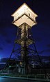
(1) The water tower at night

(2) View from the market square onto Breitstrasse, the town hall on the left

(3) Tower of the former town church with museum
(4) The town mill

(5) Church of Our Lady


The Wiprechtsburg of Count Wiprecht von Groitzsch previously stood on the castle hill. Viticulture has recently been resumed on the slopes, and information boards have been set up for visitors. Only sparse remains of the castle can be seen, but they have been archaeologically examined several times and placed under monument protection as a ground monument in 1936. In the past there was also a well-frequented restaurant here. Today there is an open-air stage for events and a corridor stone lapidarium with a collection of around 40 corridor and boundary stones , some of which come from excavated locations in the area.
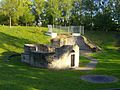
Ruins on the castle hill

Viticulture on the castle hill

Flurstone Lapidarium


Green spaces and recreation


The meadows of the White Elster and the Pfarrholz nature reserve on the Schwennigke, a left tributary of the Schnauder, are worth seeing . The Ulrike von Levetzow hiking trail leads from Groitzsch along the Schwennigke to her supposed place of birth, Löbnitz.
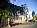
The 154 m above sea level high elevation Dreilindenberg near Wischstauden offers a good view. A network of hiking and cycling trails makes the area increasingly accessible. Excursions to the neighboring town of Pegau and the small villages between Groitzsch, Zeitz and Lucka , where numerous historic farmsteads and half-timbered houses are located, are possible here. At Hohendorf there is a geological nature trail and the path of the tree , which leads to 171 m above sea level. high New Geyersberg leads. Opencast mining viewing points such as the one at Maltitz, in the Revierpark Profen and on the B 176 at Neukieritzsch also offer a good all-round view.
The Maltitz district is located between Groitzsch and Lucka . A little to the southwest of it is the triangle of Saxony , Thuringia and Saxony-Anhalt . It is marked by the Dreiherrenstein . There is also a large wind farm here .
In addition, the Großstolpener See in the Groitzscher area offers the opportunity to swim and fish. Other bodies of water in the area belonging to the Saxon Lake District are the Haselbacher See , the Borna reservoir , the Werbener See and the Zwenkauer See .
Economy and Infrastructure
traffic

Groitzsch station shortly after its closure (2000)
Groitzsch station, renovated reception building (2011)


Until the 1990s, there was still a separate rail connection to the Neukieritzsch – Pegau line and the Gaschwitz – Meuselwitz line . Both railway lines have since been shut down. Today the next train station is in Pegau (about 5 km) on the Leipzig – Probstzella railway line , with connections to Leipzig and Gera via Zeitz . There are only public transport connections by bus, for example line 100 from Groitzsch via Zwenkau to Leipzig and line 412 to Altenburg. The Leipzig / Halle airport is about 42 km away. The B 176 runs through Groitzsch and the B 2 through the districts of Kobschütz and Audigast . The A 38 is around 15 km away.
education
In Groitzsch there is a primary school, a high school and the Wiprecht grammar school. In Borna , lessons can be taken at the music and art school. The Volkshochschule Leipziger Land also offers courses in Groitzsch. The library in Sebastianshof holds a wide range of books, magazines, videos and other media on 330 m². Users can search the electronic library catalog ( OPAC ) as they wish.

care
Several supermarkets in Groitzsch and Pegau cover the everyday needs of the residents. There is a large selection of retail outlets, two banks and a post office are on site. Over 70 independent companies from craft, trade and industry are organized in the Groitzscher trade association. A number of general practitioners and specialists, including those for internal medicine , urology and gynecology, guarantee medical care . There are a large number of dentists . The clinics in Borna and Zwenkau help with more serious illnesses . Medicines are available in two pharmacies . The Katharina von Bora nursing home was built on the outskirts of Groitzsch in the 1990s . The town hall, the city information center and the police station are located on the market.
Personalities

literature
- Günter Berthold: The fascination of the meadow landscape between Pegau and Groitzsch. Südraum-Verlag, Borna 2009, ISBN 978-3-937287-27-0 .
- Helmut Hüfner: Groitzsch. A historical representation of the city. Mitteldeutscher Kulturrat Foundation (publisher), Munich Publishing Association, 1990.
- Helmut Hüfner: The Groitzscher Berg. The Wiprechtsburg. The periods up to 1959. Part 1 and 2. Naturfreunde- und Heimatverein Groitzsch (sales), Druckhaus Zeitz, 1998.
- Helmut Hüfner: The Groitzscher Berg. The Wiprechtsburg. The 5 castle complexes. Excavation results from 1959. Part 3. Friends of Nature and Homeland Association Groitzsch (sales), Zeitz printing house, 2002.
- Robert Jahn, Albin Jahn: Groitzsch. City history in the 17th century [1601–1700]. Reichardt, Groitzsch 1900 ( digital.slub-dresden.de digitized).
- Roland Meyer, Uwe Schmidt: Groitzsch - Pictures of our city. Südraum-Verlag, Borna 2003.
- Alfred Reichardt: The register of the shoemaker's guild in Groitzsch. Degener & Co, Leipzig 1926.
- Richard Steche : Groitzsch. In: Descriptive representation of the older architectural and art monuments of the Kingdom of Saxony. 15. Issue: Amtshauptmannschaft Borna . CC Meinhold, Dresden 1891, p. 56.
- Gotthold Schröter: Groitzsch otherwise and now. Historical-statistical description of the city of Groitzsch. Publisher Paul Beirich. Groitzsch 1892 ( digital.slub-dresden.de ) digitized.
- Heinz-Joachim Vogt: The excavations on the Wiprechtsburg in Groitzsch. State Museum for Prehistory, Wurzen, Dresden 1965.
Web links
- Groitzsch in the Digital Historical Directory of Saxony
- Official website of the city of Groitzsch
- Evangelical Lutheran parish of Groitzsch
- Friends of nature and local history association Groitzsch
Individual evidence
- ↑ Population of the Free State of Saxony by municipalities on December 31, 2019 ( help on this ).
- ^ Karlheinz Blaschke , Uwe Ulrich Jäschke : Kursächsischer Ämteratlas. Leipzig 2009, ISBN 978-3-937386-14-0 ; P. 62 f.
- ^ Olaf Krenz: Schnauderbrücke conclusion: Groitzsch ends flood projects. LVZ-Online, October 25, 2017, accessed on November 1, 2017 .
- ↑ a b c d e f g h i j k l m n o p q r s t u v w x y z municipalities 1994 and their changes since 01.01.1948 in the new federal states , Verlag Metzler-Poeschel, Stuttgart, 1995, ISBN 3-8246-0321-7 , publisher: Federal Statistical Office.
- ↑ a b c d e f g h i j k l m n o p q r s lists of the municipalities incorporated since May 1945 and proof of the breakdown of the independent manor districts and state forest districts, 1952, publisher: Ministry of the Interior of Saxony.
- ↑ a b c d State Statistical Office of the Free State of Saxony: Area changes
- ↑ a b c d e f g The Saxony Book, Kommunal-Verlag Sachsen KG, Dresden, 1943
- ↑ Digital historical place directory of Saxony. Retrieved September 11, 2012 .
- ↑ Results of the 2014 municipal council elections
- ↑ statistik.sachsen.de
- ^ Manfred Bensing, Karlheinz Blaschke, Karl Czok, Gerhard Kehrer, Heinz Machatscheck: Lexicon cities and coats of arms of the GDR . Ed .: Heinz Göschel. 2. rework. and exp. Edition. Bibliographisches Institut, Leipzig July 1984, p. 172 .

Altengroitzsch • Brösen 1 • Großpriesligk 2 • Wiping perennials 1 • Large perennials • Small perennials 1 3
Audigast 4 • Kobschütz • Schnaudertrebnitz 4 5
Auligk 4 • Gatzen • Kleinprießligk • Löbnitz-Bennewitz (united in 1895) • Saasdorf 4 6 • Methewitz • Michelwitz 4 7 • Nöthnitz 4 7 8 • Maltitz • Pautzsch 4 7 9
Berndorf 4 • Kleinhermsdorf • Nehmitz 4 10 • Hemmendorf 4 11 • Hohendorf 4 12 • Langenhain • Oellschütz 4 12 13
Großstolpen 4 • Kleinstolpen 4 14 • Cöllnitz 4 15 • Pödelwitz • Droßkau 4 16 • Obertitz 4 16 17
Käferhain • Zschagast • Schleenhain • Leipen • Droßdorf 18
1 since 1948 2 since 1935 3 1933–1948 combined to form shrubs 4 since 1996 5 1948–1996 to form Audigast
6 1948–1996 to Auligk 7 1973–1996 to Auligk 8 1948–1973 to Methewitz 9 1948–1973 to Michelwitz
10 1935 ~ .. 11 1957 ~ .. 12 1974 ~ .. –1996 to Berndorf 13 1948–1974 to Hohendorf
14 1934 ~ .. 15 1948 ~ .. 16 1966 ~ .. –1996 to Großstolpen 17 1948–1966 to Droßkau 18 Desert, devastated by mining