
Groitzsch Castle
| Wiprechtsburg Groitzsch | ||
|---|---|---|
 Groitzsch Castle, core castle with the ruins of the rotunda and the residential tower |
||
| Creation time : | around 1070 | |
| Castle type : | Hilltop castle | |
| Conservation status: | Ruins of the chapel and residential tower | |
| Standing position : | Count | |
| Place: | Groitzsch | |
| Geographical location | 51 ° 9 '34.5 " N , 12 ° 16' 29.9" E | |
|
||

The Wiprechtsburg Groitzsch in the town of the same name is an outstanding ground monument with the oldest known stone buildings in Saxony . In the late 11th and early 12th centuries it was the castle of the important Count Wiprecht von Groitzsch and one of the largest complexes in the region.
location
The Höhenburg is located on the northwestern outskirts of the town of Groitzsch , opposite the town of Pegau , on the east bank of the White Elster , about 30 km southwest of Leipzig and about 15 km from Altenburg , Merseburg , Zeitz and Borna . Important traffic connections, which connected the cities mentioned and led to other medieval centers, ran through Groitzsch and past the castle.
Historical meaning
The name is derived from the Slavic grodišče , which means something like "fortified place, castle hill ". As the castle of Count Wiprecht von Groitzsch, the complex is of great historical importance. This had come to the castle around 1073/74 from the area of Stendal / Tangermünde through an exchange. The report on this is also the first reliable documentary mention of the castle. Overall, Groitzsch is one of the few castles whose fate was recorded in written sources from the 11th and 12th centuries. This made it possible to check archaeological dating and, for the first time, to receive more precise dating information for findings and finds. These apply not only to north-west Saxony, but also far beyond.
During archaeological excavations in the castle area, stratigraphically more than 6 m high layer complexes were excavated. These show the continuous development of both the method of fortification and the material culture in five consecutive castle periods from the 10th to the end of the 13th century. Groitzsch is one of the few plants in East Thuringia and West Saxony with a longer continuous settlement and was named for the Middle and Late Slavic ceramics of the 10th and 11th centuries (" Groitzsch Group ").
In the construction phases I and II, the fortification was formed by a rust-like core , which - albeit in different forms - is widespread in the western Slavic region. The Wiprechtsburg, which was built in the last quarter of the 11th century, marks the transition from wood-earth construction to mortar-bound stone construction in a special way . A round chapel and a round tower are considered to be the oldest stone buildings in Saxony. These buildings heralded the construction of numerous other sacred and profane stone buildings in (Upper) Saxony in the 12th century.
Todays use
The castle ruins can always be visited free of charge. The partially reconstructed round chapel and the stump of a round tower, both of which date from around 1080, are particularly worth seeing. In the summer months, events such as open-air concerts or performances often take place in the amphitheater- shaped area. A vineyard with over 5,000 vines , flower beds and hiking trails was created. The lapidarium in the interior of the castle now includes a collection of around 40 corridor and boundary stones from the region.
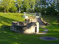
Ruins on the castle hill

Viticulture on the castle hill

Flurstone Lapidarium


Topographical situation
The castle lies on a spur of the terrain consisting of Pleistocene gravel , which extends far into the wide valley of the White Elster . It is surrounded by the Schwennigke magpie tributaries in the southwest, west and north and, further east, the Schnauder . Due to the fortification favorable location, a section fortification was built here in the spur position. The castle grounds are now intersected by a road that leads from Pegau to the town of Groitzsch. This runs largely in the medieval castle moat , a former wide dry moat . To the west of this is the main castle, which is around 10 to 12 m higher than the street. Only in the east does the 150 × 100 m large castle have an approximately 4 m high section wall , the other sides drop off steeply to Schwennigke . To the east of the street there is an outer bailey with three times the area. This was originally also fortified, but only remains have survived on the east side. In addition, a ditch was upstream, which only z. T. is detectable. Today, the area is mainly occupied by a nursery, a cemetery and the church area with the remains of the Romanesque Frauenkirche . To the south of the outer bailey is the medieval old town of Groitzsch.
Research history
As early as 1743, the court lord von Groitzsch, Baron von Schwedendorf, had "excavations" carried out. Since parts of the construction - pieces of wood that "look like a grate" - were found at a depth of around 10 m , they probably dug in the area of the castle fortifications. In 1849, during construction work for a restaurant on the main castle , the walls of a Romanesque rotunda (round chapel) were exposed and the interior of the church was excavated. This was quickly filled by the slope erosion and with rubbish, so that it had to be dug up again after 75 years. In 1863 a “Committee for the Raising of the Treasure” in Wiprechts had the Schwennigke pumped out, but found a modern horseshoe, a sword blade and a sword basket in addition to a rich fish harvest. As an important and well-preserved ground monument, the Wiprechtsburg was placed under monument protection as early as 1936 . Plans for the construction of a retirement home in the 1950s initially led to investigations of the excavation pits in 1959, which quickly expanded into long-term research excavations and continued until 1967/68 under the direction of Heinz-Joachim Vogt. Then the round chapel and the remains of a Romanesque round tower discovered during the excavations were restored and the surrounding area was designed in the shape of an amphitheater as a recreational facility.
Excavation results and construction phases of the castle
Prehistoric finds
Remains of a prehistoric cultural layer could only be found in a few places in the main castle and in the outer castle . The finds, v. a. Ceramics and stone utensils, to a large extent, belong to the Neolithic (especially funnel beaker culture ), but there are also a few Bronze and Iron Age pieces among them. Overall, however, the areas examined were too small to be able to make any further statements.
Period I: 10th century
The bottom of the embankment consisted of a grate construction at least 8 m wide and 2.80 m high made of halved oak logs and small round timbers. Then a 2.9 m wide wood-earth wall rose on the inner wall front, to which a 5 m wide humus clay pack was attached on the outside . The nature of the outer wall front could no longer be determined. Also, due to the construction work on the later fortifications, it remains unclear whether superstructures were built on the wall and whether a ditch delimited the main castle in the east.
Due to the encroachments and rearrangements in the construction of Castle II and the small area, it was hardly possible to make more precise statements about the settlement of the inner area. It apparently began immediately behind the wall and was rather small towards the center of the castle. Due to the thick layers of charcoal immediately behind the wall, Vogt suspected a wooden structure here. A first hearth was found 4 m behind the back of the wall, which probably belonged to a mine house . Another pit house had apparently been destroyed by fire, which had also affected the entire fortification. Even in the first castle, efforts were made to move the slope outwards in order to gain a larger inner surface. For this purpose, the inner surface was leveled and the remains of the settlement were tipped down the slope, widening the entire north side by almost 20 m.
The stratigraphic separation of pottery from Period II was only possible in very few places. Approaches for dating offer parts of a spiked spur that probably belongs to the first half of the 10th century. The foundation of the first fortification will also take place at this time, the end of Castle I, due to a fire, can be dated to the second half of the 10th century. The founding is mostly associated with the historical event of the conquests of Henry I in 928, as a result of which Meißen Castle was founded. It is possible that the Altengroitzsch castle wall about 2 km to the south , of which mainly finds from the 9th and early 10th centuries is available , was also replaced at this time .
Period II: late 10th century (?) To around 1080
On the leveled remains of the castle wall of the first castle, a grate construction similar to that in Castle I was erected and the debris was poured on the slope side as the basis for the wall. Stones that could indicate dry stone walls are missing here. In the eastern part of the section there was evidence of a tower built from strong trunks, but this could not be completely uncovered. The interpretation of the finding as a tower is difficult, it could also be a gate, but according to Vogt, the terrain speaks against it.
The interior settlement was denser than in Castle I. It also began directly behind the wall, but encompassed the entire interior area, with several hearths and parts of pit houses being examined. Here, too, the cut-outs were too small to be able to provide more precise information on the floor plan.
In the archaeological finds, a rich bone material enabled a good insight into the food habits of the castle residents. 98.6% of the bones come from domestic animals , with pigs dominating here. The hunting played a subordinate role, which v. a. can be determined in comparison to fortifications at the same time in the Brandenburg area. Again, the wild boar was the most popular. Furthermore, a large number of bone tools like awls recovered and needles, or Schlitt bones. The latter were most likely used as sled runners to transport heavy loads and not as ice skates. Spores, tang knives and fire steels have been found on iron implements and other metal finds . The other pieces are also typical municipal waste: fragments of a handle , probably from a wooden bucket, boiler hooks , fittings and belt parts. Several iron slags suggest iron processing by one or more blacksmiths in the castle.
Due to the ceramic and metal finds, Castle II can be dated to the 10th and 11th centuries. The fortification fell victim to extensive destruction, which is documented in thick layers of fire. It cannot be clarified whether this is to be connected with the disputes between Wiprecht and the surrounding nobles in the 1070s, or the investiture dispute , which reached its climax here with the Battle of Hohenmölsen in 1080.
Period III: around 1080 to around 1120

The following Castle III was built according to completely new principles, which applies to both the fortification system and the interior construction. The rubble layers of castles I and II formed the foundation for a huge heaped wall of sand and gravel, which had a base width of 27 to 30 m. The fortification towered over the former courtyard level by 8-10 m. The outer slope was again moved outwards, this time by an average of 10 m. The inner front was formed by a box construction with a thickness of 2.80 m. This consisted of 2–4 cm thick planks installed horizontally, one on top of the other and cladded at an angle, making boxes 3.80 in length and of various widths (80 cm – 3.50 m). Some of them were still up to 3.20 m high and filled with sand, coarse gravel and in places clay. The inner wood-earth wall could be traced over a length of more than 25 m. It surrounded the wall polygonally on the north, east and south sides. The purpose of this construction was probably to absorb the enormous side pressure of the wall and possibly other superstructures and to prevent the sand masses from flowing off onto the inner surface of the castle. Vogt suspected further buildings on the 15 to 18 m wide crown of the wall, i.e. defensive structures, which could no longer be proven, however, as later construction work removed all remains.
The inner wall area was apparently separated into an eastern and western part by embankment-like embankments. The latter is the larger part, but it could not be examined. The interior settlement was also designed completely differently than in the previous castles. In the first phase of the castle expansion, wooden houses behind the box construction and a pit house with an entrance ramp are proven. The mine house, which has not been completely uncovered, probably belongs to a workshop of stonemasons , because a horizon of stone fragments could be determined in the sand directly above the layers of Castle II. This is related to the construction of a Romanesque round tower with an inner diameter of 9.30 m and a wall thickness of 2.00 m. This obviously served both residential and defensive purposes and is probably identical to one of the two towers mentioned in the Pegau Annals. A little later the Romanesque round chapel with an inner diameter of 6.4 m and a horseshoe-shaped apse was built about 10 m away . The construction horizon was followed by four more levels, some of which were covered with planks. So they were clearly replacing courtyard horizons and speak in favor of longer-term use of this facility. Thicker layers of clay on the plank coverings made it necessary to renew them frequently. In the second courtyard phase, a wooden house was built in the north of the castle, just 50 cm behind the box construction, using the same technology as the boxes. A collapsed dome furnace was found in one corner. Immediately after the completion of the fifth courtyard, the castle was partially destroyed and layers of rubble covered the courtyard surface. At the same time, the outer bailey was expanded by building a fortification - probably with palisades - and with more intensive settlement. It is possible that a predecessor of the Romanesque St. Mary's Church has already been built.
Based on the excavated animal bone material and with the help of osteological investigations, it was possible for the first time to prove tax ratios for West Saxony. In the case of the cattle bones, it was clear that no whole animals, but only the meat-rich portions were delivered to the castle. As with the older castles, the proportion of wild animals is surprisingly low (1.2%). The fact that bones of red deer , wild boar , elk and bison as well as brown bears - animals of the " high hunt " - can be detected underlines the social position of the lords of the castle. This is also made clear by the high proportion of prey bones , which certainly played a role in the hunt . The keeping of peacocks and dachshund-like dogs can also be seen as an indication of a more or less courtly culture .
Numerous ice bones can again be named among the finds, although in one case it is actually a skate blade. Other ornate bone objects include needles, parts of combs, a bone handle, a flute and a cube. Iron implements such as knives are relatively rare. The parts of knife sheath fittings and a large number of nails and staples are made of bronze. A special object is the lead scales with a lead weight that is probably associated with it. A number of glass finger rings and the remains of a bronze bobble are known to be found on jewelry objects. On the remains of equestrian equipment, horse and armament there is a checkerboard decorated golden bridle and several wave horseshoes . In addition to late Slavic ceramics, a new, disk-turned, thin-walled and hard-fired ceramic appears for the first time, which is much better quality than the previous one and is referred to as "inconsistently fired earthenware".
Castle III is undoubtedly the castle of Count Wiprecht von Groitzsch . Not only the mention of the towers and the complete redesign of the castle in the Pegau annals for the year 1080, but also the structural design of the excavated tower speak for its dating to the end of the 11th century. The main distribution area of the round chapel, which was built only a little later, is Bohemia and Moravia , where Wiprecht had close ties, which found its strongest expression in the marriage of the Přemyslid king's daughter Judith of Bohemia. The construction principle of fastening with a heaped wall and a box construction as an inner wall is so far unknown in Upper Saxony. Its main distribution area is in the western Elbe region (Hannoversches Wendland ) and can also be detected in Obodritic castles in Mecklenburg and Denmark . Wiprecht came from the area around this room. A C-14 determination gave a date of 1120 ± 40 years. The ceramics as well as the other finds speak for this dating and with their high quality for the special importance of the castle at this time. The end of the castle documents a horizon of destruction that is archaeologically dated to the first decades of the 12th century. It can be related to the disputes between Wiprecht and Heinrich V around 1115, during which the castle was conquered and recaptured several times.
Period IV: around 1120 to 1224
Remnants of the fortifications of this castle have not survived, as extensive leveling was carried out for the subsequent Castle V, which removed the fortification as well as most of the other findings of Castle IV. However, the excavator Vogt thought he could deduce from stratigraphic findings on the outer slope that Castle IV was enclosed by a brick wall.
Inside the facility, the courtyard was raised by at least three to four meters in order to keep up with the level of the wall crown and to counter the constant moisture in the courtyard. For this purpose, large box-like fixtures were built in the courtyard, which were then filled with rubble. The area between the round chapel and the tower was initially left out. The round chapel initially continued to function, it was only accessible from the north-west side, on the old level. The castle gate may also have been near the round tower. In the first third of the 13th century, leveling and construction measures were carried out again. The remaining boxes were filled with the rubble and the overall level of the courtyard was raised, with the round chapel being abandoned. This achieved a uniform courtyard level. The now mothballed tower was still used. During these construction measures, a half-timbered building in the south-east corner of the castle on the wall, in which the oldest pot-tiled stove to be found east of the Saale , was also removed . In addition to half-timbered buildings, there were also brick buildings.
Overall, the finds show few changes to Castle III. This applies to food residues, especially the portion of animal bones, as well as to production instruments and objects from the house and yard. There are also sled bones, knife blades and scabbard fittings, whetstones and whetstones, nails, etc. Special mention should be made of the bronze bell and the bronze object with a mandrel of indefinite function. In addition, there are only a few jewelry objects and weapons and riding equipment here. The ceramics have hardly changed either. Some late Slavic pieces still appear, but the inconsistently fired earthenware dominates.
The castle can be dated to the 12th and early 13th centuries based on the finds. After the Groitzsch family died out in 1144, the castle fell to the Wettin Dedo V. ("the Feisten") , who had received the allodial property through the marriage of Berthas, Wiprecht's daughter. However, Dedo most likely took his seat at his castle in Rochlitz . A siege of the fortifications and arson in the outer bailey by Thuringian Landgrave Ludwig IV. The saints are attested for 1224 , which very likely meant the end of Castle IV.
Period V: 1224 to around 1300
The castle was largely the same size as its predecessor, but apparently the function of the castle had completely changed. The fortification system consisted of two brick walls, which ran parallel to each other on the slope and on the outer edge of the castle area. In the northeast part of the castle two vaulted square brick towers with a central support were excavated. They had an inner side length of about 10 m and were probably also part of the fortification.
The inner area of the castle was first increased with the rubble from the buildings destroyed at the end of period IV and the defense tower, as far as it was still accessible, was then gradually removed for stone extraction. Several brick buildings, of which some remains of walls and probably sub-foundations were found, indicate different needs. It is difficult to make more precise statements because the remains were just below the surface and v. a. were permanently disrupted during the construction of the restaurant and other building measures. In addition to larger building complexes, there were probably horse stables on the south side of the castle, as the finds made in the building suggest. Glazed roof tiles and gable ends emphasized the representative character of the complex. This castle was also violently destroyed, like layers of rubble and ash and v. a. clearly document embedded human remains.
The most extensive finds of all five fortifications come from Castle V. Almost suddenly a completely new type of ceramic, so-called gray / blue-gray earthenware, appears, which completely dominates the picture. Glazed ceramics are being used in increasing numbers, the fragment of a toy horse with a rider deserving special mention. There are also fragments of two Aquamaniles (hand washing / watering vessels). The other rich finds give a cross-section of the inventory of a medieval castle: various production tools such as drills, chisels, axes, bone handles for tools, as well as knives, fittings, socket and beard keys, etc. Horseshoes, spurs and stirrups show the presence of horse and rider. Furthermore, parts of the armament such as knives, swords (crossguard) as well as arrow and crossbow points are available.
The beginning of Castle V around 1224 is secured by the occurrence of gray / blue-gray earthenware. Due to a bracteate box made between 1280 and 1288 and the lack of younger types of ceramic, the end of the castle can be dated to around 1300. The castle was probably completely destroyed in the Wars of Succession in 1294 or 1296 by the troops of Adolf von Nassau or, at the latest, when the troops of his successor King Albrecht I moved through in 1306/07.
On the western edge of the castle hill, there was still a small tower hill fortification, to which the rights and duties associated with the burgrave office were transferred. However, the Groitzsch office had largely lost its importance.
exhibition
One area in the permanent archaeological exhibition in the State Museum of Archeology in Chemnitz is dedicated to Groitzsch Castle.
literature
- Susanne Baudisch: Castles and manors in northwest Saxony. Exit 11th century to mid-14th century. Haus Katzbach, Regis-Breitingen 1996. ISBN 3-930044-04-8
- Hansjürgen Brachmann : On the building of castles in the Salian period between the Harz and Elbe. In: Horst Wolfgang Böhme (Hrsg.): Castles of the Salierzeit. Part 1. In the northern landscapes of the empire. Publication for the exhibition “The Salians and their empire”. RGZM monographs. Vol. 25. Thorbecke, Sigmaringen 1992, pp. 97-148 (on this especially 135-137). ISBN 3-7995-4134-9
- Lothar Herklotz: Groitzsch, Wiprechtsburg. In: Leipzig and its surroundings. Archeology between Elster and Mulde. Guide to archaeological monuments in Germany. Vol. 32. Theiss, Stuttgart 1996, pp. 142-146. ISBN 3-8062-1272-4
- Yves Hoffmann: A “tower dispute” or a dispute over methods? About dating buildings. in: Castles and palaces in Saxony-Anhalt. Halle Saale 9.2000, pp. 67–83 (see 78f.). ISSN 0944-4157
- Herbert Küas , Manfred Kobuch: Round chapels of Wiprecht von Groitzsch. Structure and history. Publications of the State Museum for Prehistory. Vol. 15. Deutscher Vlg der Wissenschaften, Berlin 1977. ISSN 0070-7201
- Herbert Küas: Stone buildings of the Wiprechtsburg near Groitzsch, Borna district, since the end of the 11th century. in: Work and research reports on the preservation of monuments in Saxony. State Office, Dresden 23.1979, pp. 107–146. ISSN 0402-7817
- Heinz-Joachim Vogt: The Wiprechtsburg Groitzsch. A medieval fortification in West Saxony. Publications of the State Museum for Prehistory Dresden . Vol. 18. Berlin 1987. ISBN 3-326-00067-7
- Heinz-Joachim Vogt: The archaeological investigation on the Wiprechtsburg near Groitzsch, Kr. Borna. In: Archaeological field research in Saxony. Work and research reports on the preservation of monuments in Saxony. Supplement 18. Berlin 1988, pp. 387-396. ISBN 3-326-00337-4 .
- Thomas Nabert (Ed.): In the Elsterland between Zwenkau, Groitzsch and Pegau. Edited by Pro Leipzig in collaboration with the cities of Zwenkau, Groitzsch and Pegau. Leipzig 2002. ISBN 3-936508-92-5 .
- Gerhard Cheap, Heinz Müller: Castles - Witnesses of Saxon History . Neustadt ad Aisch, 1998.
- Heinz-Joachim Vogt: Archaeological investigations in the castle Wiprecht von Groitzsch . In: Castle research from Saxony. 1992.
Web links
- The Wiprechtsburg on the website of the Leipziger Neuseenland eV tourism association
- Historical reconstruction drawing