Hringvegur

The Hringvegur [ 'r̥iŋkˌvεːɣʏr̥ ] (dt. Ring road ) or also ðjóðvegur 1 (dt. National road 1 ) is a main traffic connection in Iceland and as such part of the Icelandic road system . The entire ring road has been paved since August 2019. With the exception of a few bridges, it also has two lanes throughout, and three to four lanes in and around Reykjavík.
course
The Hringvegur runs around the main island of Iceland (with the exception of the Westfjords ) over a total length of 1341 km (as of 2017). Almost all of the important cities and towns are located on it, from the capital Reykjavík to Borgarnes , Akureyri , Egilsstaðir , Höfn and Selfoss .
The route between Egilsstaðir and Breiðdalsvík was changed in November 2017 . The map still shows the old course. The first part from Norðfjarðarvegur almost to Reyðarfjörður was renamed the ring road, as was the entire Suðurfjarðavegur . The former course of the ring road in this area has become Skriðdals- og Breiðdalsvegur (road 95), which is not yet asphalted. As a result, the ring road was 10 km longer, but it is completely paved on this stretch.
From Reykjavík to Borgarnes
-
Reykjavík , Vesturlandsvegur (km 0)
-
 - 430
- 430
-
- Mosfellsbær
-
 - 36 to the lake Þingvallavatn
- Hofsvík
-
 - 47 around Hvalfjörður
-
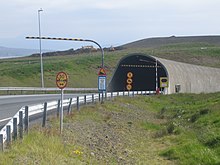
 Hvalfjarðargöng (tunnel; length: 5762 m, height: 165 m)
 -
 - 503 according to Akranes
-
 - 51 after Akranes
-
 - 47 around Hvalfjörður
-
 - 504 to Leirá
-
 - 505
- 505
-
 - 53 after Hvanneyri
-
 Borgarfjarðarbrú (bridge; length: around 500 m)
 - Borgarnes
From Borgarnes to Blönduós

-
Borgarnes
-
 - 54 to the Snæfellsnes peninsula and Ólafsvík
-
-
 - 530 to 53
-
 - 53 after Hvanneyri
-
 - 553 to Langavatn
-
 - 50 to Reykholt
- Borgarbyggð
-
 - 60 to Buðardalur and the Vestfirðir region
- Hvammur
-
 - 61 to Hólmavík and the Vestfirðir region
- Staður
-
 - 702 to Heggstaðanes
-
 - 704 to the F578
- Laugarbakki
-
 - 72 to Hvammstangi
-
 - 711 to the Vatnsnes peninsula
-
 - 714
- 714
-
 - 715
- 715
- Lækjamót
-
 - 721 to Þingeyrar
-
 - 722
- 722
-
 - 724
- 724
-
 - 725
- 725
From Blönduós to Akureyri
- Blönduós
-
 - 731
- 731
-
 - 741
- 741
-
 - 74 to Skagastrond
- Holtastaðir
-
 - 734
- 734
-
 - 762
- 762
-
 - 752 to Steinsstaðabyggð
From Akureyri to Egilsstaðir
-
 - 83 to Grenivík
-
 - 834
- 834
-
 - 835
- 835
-
 - 85 to Húsavík
-
 - 841
- 841
-
 - 847
- 847
-
 - 848 to Mývatn
-
 - 860
- 860
- Reykjahlíð
-
 - 863 to Krafla
-
 - F862
-
 - F88 to Askja
-
 - 864 to Dettifoss and Ásbyrgi
-
 - 901 to Möðrudalur
-
 - 85 to Vopnafjörður
-
 - 923
- 923
-
 - 924
- 924
-
 - 925
- 925
-
 - 929
- 929
-
Fellabær
-
 - 931
- 931
-
- Egilsstaðir
From Egilsstaðir to Höfn
- Egilsstaðir
-
 - 95 Ringstrasse until November 2017
 -
 - 93 to Seyðisfjörður
-
 - 94 to Bakkagerði / Borgarfjörður eystri
-
-
 - 953 in the Mjóifjörður
-
 - 92 to Reyðarfjörður , Eskifjörður and Neskaupstaður
-
 - 936 can only be used in summer
 -
 - 955 former Suðurfjarðarvegur
 -
 Fáskrúðsfjarðargöng (tunnel; length: 5.9 km)
 -
 - 955 to Fáskrúðsfjörður
- Stöðvarfjörður
-
 - 95
- 95
- Breiðdalsvík
-
 - 96 to Reyðarfjörður
-
 - 939
- 939
-
Djupivogur
-
 - 98 to Djupivogur airfield
-
-
 - F980
-
 Almannaskarðsgöng (tunnel; length: 1,312 m)
 -
 - 99 to Höfn
- Hofn
From Höfn to Selfoss
-
 - 984
- 984
-
 - 986
- 986
-
 - F985
-
 - 998
- 998
-
 Morsárbrú
-
 Skeiðarárbrú , out of order, was the longest bridge in Iceland
-
-
Kálfalfell
-
 - 201
- 201
-
-
 - 202
- 202
- Kirkjubæjarklaustur
-
 - 215
- 215
-
 - 218
- 218
-
 - 219
- 219
-
 - 222
- 222
-
 - 221
- 221
-
 - 242
- 242
-
 - 243
- 243
-
 - 245
- 245
-
 - 246
- 246
-
 - 247
- 247
-
 - 249
- 249
-
 - 251
- 251
-
 - 252
- 252
-
 - 255
- 255
- Hvolsvöllur
-
 - 264
- 264
-
 - 266
- 266
-
Hella
-
 - 25 to Þykkvibaer
-
-
 - 26 (Landvegur) towards Sprengisandur
-
 - 30
- 30
-
 - 33 after Stokkseyri
- Selfoss
From Selfoss to Reykjavík
-
Selfoss
-
 - 34 after Stokkseyri
-
-
 - 35 to Gullfoss and earlier F35
-
Hveragerdi
-
 - 38 to Þorlákshöfn
-
-
 - 38 to Þorlákshöfn
-
 - 417 to Hafnarfjörður
-
 - 41 to Keflavík Airport
- Reykjavík (km 1 339)
history
First, the connection to the north towards Akureyri was expanded and to the south-east towards Selfoss via the Hellisheiði , keeping roughly the course of the former main connection routes. These still looked quite adventurous in the 1930s, as you can easily see from the preserved pieces on the Holtavörðuheiði , for example. It is not for nothing that a couple who dared this adventure proudly presented themselves to the photographer on this plateau (memorial plaque on Kattahrýggur).
In the 1970s, the southern route to Höfn began to be expanded across the Skeiðarársandur plain and the ring road was finally completed on July 14, 1974 with the bridge over the Skeiðará . However, they knew of the dangers this part of the road would face. In fact, it was partially destroyed during the 1996 glacier run between Kirkjubæjarklaustur and Skaftafell . The crumpled remains of the steel skeleton of a destroyed bridge can still be seen today. From 1972 to 1995 the road was also named Suðurlandsvegur, Vesturlandsvegur, Norðurlandsvegur and Austurlandsvegur in sections, depending on the parts of the country through which it runs. You can still find these names in older maps and in navigation systems.
The whole street has been paved since August 2019. Most recently, there was only a short stretch in East Iceland (on Berufjörður between Djúpivogur and Breiðdalsvík ) as a gravel road, since the Hringvegur no longer officially leads over the Breiðdalsheiði , but through the Eastfjords due to a change in the numbering in November 2017 . New routes and the opening of tunnels are also shortening the route, for example the construction of the tunnel under Hvalfjörður near Akranes and the tunnel under the Almannaskarð pass east of Höfn , which opened in 2005 . This is where the greatest incline on the Ringstrasse used to be.
Outline of the history of the Hringvegur
- 1928: The Hvítá Bridge in Borgarfjörður was built. It was later replaced by a newer bridge.
- 1930–1940: The road around Hvalfjörður was completed. This created a continuous road connection between Reykjavík and Akureyri .
- 1933: The old bridge over the Markarfljót was built. It was later replaced by a newer one.
- 1945–1946: The current bridge over the Ölfusá became necessary after the previous one collapsed.
- 1947: The bridge over the Jökulsá á Fjöllum near Grímsstaðir went into operation. It shortens the route between North and East Iceland. Before that you had to drive over the Öxarfjörður .
- 1949–1950: The old bridge over the Þjórsá was built and replaced the first Þjórsá bridge from 1895. It was later replaced by a newer one.
- 1952: The bridge over the Jökulsá í Lóni was built.
- 1958: The current bridge over the Lagarfljót between Egilsstaðir and Fellabær was built.
- 1961: The bridge over the Hornafjarðarfljót near Höfn was built.
- 1962: The current bridge over the Blanda near Blönduós was built.
- 1967: The bridge over the Jökulsá á Breiðamerkursandi near Jökulsárlón was built.
- 1967: The current bridge over the Jökulsá á Sólheimasandi was built.
- 1967: The bridge over the Eldvatn near Ásar was built after the previous one collapsed. It was later replaced by the bridge over the Kúðafljót .
- 1968: The current bridge over the Fnjóská was built and replaced its predecessor from 1908.
- 1972: The new road between Reykjavík and Selfoss was re-routed and paved as it mostly runs today.
- 1972: The current bridge over the Skjálfandafljót at Goðafoss was built. Your predecessor is still standing today.
- 1974: The road over the Skeiðarársandur was completed and thus the last part of the ring road. The bridges over the Skeiðará , Sandgígjukvísl and Núpsvötn are among the five longest in the country.
- 1979–1980: Work on Borgarfjarðar Bridge, the second longest in Iceland, was completed. It shortens the route and replaces the bridge from 1928 on the route over Hvanneyri and Hvítárvellur.
- 1980: The stretch between Selfoss and Hvolsvöllur was paved.
- 1981: The current bridge over the Héraðsvötn was built and replaced the bridge at Grundarstokkur.
- 1983–1986: The road over the Víkurskarð pass was put into operation. It replaced the path over the Vaðlaheiði .
- 1986: A new, more northerly road in Eyjafjörður near Akureyri was opened and replaced three older bridges. They led over individual arms of Eyjafjarðará at the airport level .
- 1988: A new and better road was built across the Mýrdalssandur , replacing the road that passed Hafursey further north .
- Around 1990: the road around Hvalfjörður was paved and thus the last stretch between Reykjavík and Borgarnes .
- 1990: A new bridge over the Múlakvísl was built and destroyed in 2011 during a glacier run .
- 1991–1992: The current bridge over the Markarfljót was opened to traffic. It replaced a bridge from 1933 and shortened the now paved road between Hvolsvöllur and Vík í Mýrdal .
- 1993: The bridge over the Kúðafljót was built and considerably shortens the distance between Vík í Mýrdal and Kirkjubæjarklaustur .
- 1994: The current bridge over the Jökulsá á Brú was built and replaces the old one on a winding stretch.
- 1994–1995: The asphalting work on the last sections between Reykjavík and Akureyri was completed.
- 1996: A big glacier run on the Skeiðarársandur took the bridge over the Sandgígjukvísl with it, damaged the Skeiðarárbrú and a large part of the route over the Skeiðarársandur.
- 1996–1998: Hvalfjarðargöng was built and opened in 1998 and saves the trip around Hvalfjörður. This is the first tunnel on the ring road and also the first submarine tunnel in Iceland.
- 1998: The new bridge over the Sandgígjukvísl was put into operation after the great glacier run in 1996.
- 1999–2000: The last sections between Vík í Mýrdal and Höfn í Hornafirði were asphalted.
- 2000: The road near Grímsstaðir was re-routed and shortened the ring road.
- 2000: The ring road was now led over the new Háreksstaðaleið instead of the Möðrudalsleið . This made a year-round connection between Norðurland and Austurland possible.
- 2003: The current bridge over the Þjórsá was built and replaced the one from 1949/1950. The road shortened a little.
- 2004–2005: The Almannaskarðsgöng was dug, opened in 2005 and replaced the 16.5% steepest part of the ring road over the Almannaskarð .
- 2004–2008: The Vesturlandsvegur from Reykjavík to Mosfellsbær was widened from two to four lanes and the intersections were expanded.
- 2005: The new road over the Svína Lava and an intersection-free connection to road 39 (Þrengslavegur) were inaugurated.
- 2007: The new road in Norðurárdalur (east of Varmahlíð ) was put into operation and replaced four single-lane bridges.
- 2007–2008: The road at Arnórsstaðamúli was renewed and paved. This means that the entire route between Akureyri and Egilsstaðir is paved.
- 2008: The road and bridge inside in Hrútafjörður were built. A single lane and the old bridge over the Hrútafjarðará near Brú í Hrútafjörður.
- 2008: The road at Stafholtstungur and Norðurárdalur ( Borgarfjörður ) was inaugurated. Before that, this route was one of the most dangerous on the Ringstrasse.
- 2010–2011: The road at Sandskeið was widened from two to four lanes.
- 2011: The bridge over the Múlakvísl was destroyed during a glacier run and replaced by a makeshift bridge within 100 hours.
- 2013–2015: The road across Hellisheiði was widened to three lanes.
- 2014: The new bridge over the Múlakvísl replaced the one destroyed during the 2011 glacier run.
- 2013–2018: The Vaðlaheiðargöng is dug. It replaces the route over the Víkurskarð .
- 2016–2017: The new bridge over the Morsá is built and replaces the Skeiðarárbrú , which is mostly dry and has to be serviced.
- 2017: Part of the Norðfjarðarvegur and the whole of Suðurfjarðavegur were added to the ring road with the opening of the Norðfjarðargöng , while the previous, not yet completely asphalted section over the Breiðdalsheiði became Skriðdals- og Breiðdalsvegur with the number 95.
- 2016–2019: The road inside Berufjörður is renewed and paved. Since then, it has been possible to drive around the country on paved roads.
meaning
The Hringvegur is the most important traffic artery in Iceland. It enjoys unbroken popularity with tourists in Iceland , as there are numerous sights in its vicinity.
In recent years, artists have also adopted it and made it the subject of films and novels, such as the film Hringurinn by Friðrik Þór Friðriksson (1984) and the novel Hjartastaður ( Heart of the City ) by Steinunn Sigurðardóttir (1995).
literature
- Conrad Stein / Hans Peter Richter: Around Iceland on the Ringstrasse , Conrad Stein Verlag, ISBN 978-3-86686-288-3
See also
Web links
- Long-term expansion plans for the roads / red on the map
- A tour on the Ringstrasse, SPIEGEL article
- The Icelandic Road Construction Office with road patrol (English)
- Map showing the road surface (asphalted: black b. 2009, red b. 2010, rest not asphalted) (Icelandic)
- To complete the Hringvegur and the construction of the bridge on the Skeiðarársandur (with map) (Icelandic)
Individual evidence
- ↑ Bundið slitlag allan hringinn. Retrieved August 20, 2019 (Icelandic).
- ↑ Vegaskrá 2018 - kaflaskipt. Retrieved November 16, 2018 (Icelandic).
- ↑ Breytt vegnúmer á Austfjörðum - Hringvegurinn mun liggja um firðina. Retrieved November 10, 2017 (isl.).
- ↑ Malbik allan hringinn ( Icelandic ) In: mbl.is . Morgunblaðið. August 1, 2019. Accessed April 23, 2020.


