Eyjafjarðará
| Eyjafjarðará | ||
|
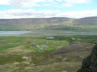
The mouth of the Eyjafjarðará, Pollurinn with the airport runway, middle distance, left center, Eyjafjörður with Hringvegur bridge on the far left |
||
| Data | ||
| location | Iceland | |
| River system | Eyjafjarðará | |
| Drain over | Eyjafjörður → Greenland Sea | |
| source | on the plateau of the Eyjafjörður valley | |
| muzzle |
Hvítá coordinates: 65 ° 39 ′ 36 ″ N , 18 ° 4 ′ 22 ″ W 65 ° 39 ′ 36 ″ N , 18 ° 4 ′ 22 ″ W.
|
|
| length | 70 km | |
| Flowing lakes | Pollurinn | |
| Medium-sized cities | Akureyri | |
| Communities | Eyjafjarðarsveit , Akureyri | |
The Eyjafjarðará is a river in northern Iceland .
course
It rises in the upper valley of Eyjafjörður and flows into Lake Pollurinn after about 70 km at Akureyri airport . The lake then flows into the southern end of Eyjafjörður.
fishing
The Eyjafjarðará is popular with anglers for its salmon and trout.
