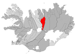
Eyjafjardarsveit
| Basic data | |
|---|---|
| State : |
|
| Region: | Norðurland eystra |
| Constituency : | Norðausturkjördæmi |
| Sýsla : | Eyjafjarðarsýsla |
| Population: | 1042 (January 1, 2019) |
| Surface: | 1775 km² |
| Population density: | 0.59 inhabitants / km² |
| Post Code: | 601 |
| politics | |
| Community number | 6513 |
| Mayor: | Bjarni Kristjánsson |
| Contact | |
| Address of the municipal administration: | Syðra-Laugalandi 601 Akureyri |
| Website: | www.eyjafjardarsveit.is |
| map | |

Coordinates: 65 ° 34 ′ N , 18 ° 6 ′ W |
|
The municipality of Eyjafjarðarsveit is located in northern Iceland in the Norðurland eystra region . On January 1, 2019, the community had 1,042 inhabitants.
geography
The municipality is located in the Eyjafjarðardalur valley. The larger settlements are Hrafnagil (270 inhabitants), Brúnahlíð (72 inhabitants) and Kristnes (47 inhabitants) (as of January 1, 2019). The next larger city is Akureyri , located north of the valley exit .
history
An incorporation to Akureyri was rejected in a referendum on October 8, 2005. The municipality itself was created on January 1, 1991 through the merger of the rural communities Hrafnagil ( Hrafnagilshreppur ), Saurbær ( Saurbæjarhreppur ) and Öngulsstaðir ( Öngulsstaðahreppur ).
Population development
As with many Icelandic municipalities outside the southwestern regions, growth has been recorded again after stagnation or even population decline.
| Year * | Residents |
|---|---|
| 1997 | 928 |
| 2003 | 958 |
| 2004 | 993 |
| 2005 | 978 |
| 2006 | 998 |
| 2009 | 1039 |
* on December 1st
Web links
- Local government website (Icelandic)