Norðurþing
| Basic data | |
|---|---|
| State : |
|
| Region: | Norðurland eystra |
| Constituency : | Norðausturkjördæmi |
| Sýsla : | Norður-Þingeyjarsýsla |
| Population: | 3042 (January 1, 2019) |
| Surface: | 3729 km² |
| Population density: | 0.82 inhabitants / km² |
| Post Code: | 640, 641 (Húsavík) 670, 671 (Kópasker) 675 (Raufarhöfn) |
| politics | |
| Community number | 6100 |
| Mayor: | Reinhard Reynisson |
| Contact | |
| Address of the municipal administration: | Stjórnsýsluhús Ketils Bride 7-9 640 Húsavík |
| Website: | www.nordurthing.is |
| map | |

Coordinates: 66 ° 3 ′ N , 17 ° 21 ′ W |
|
The municipality of Norðurþing is located in northeast Iceland in the Norðurland eystra region . On January 1, 2019, the community had 3,042 inhabitants.
geography
In the north of the municipality are the places Kópasker and Raufarhöfn on the 30 km wide and 40 km long Melrakkaslétta peninsula (Eng. "Plane of the arctic foxes"), which protrudes in the east of Öxarfjörður into the North Atlantic . With the Hraunhafnartangi you will find the northernmost lighthouse in Iceland. The west of the municipality lies on the Skjálfandi bay .
The municipality of Tjörnes , which borders the municipality of Norðurþing in the north-west, is surrounded by it and the Atlantic Ocean. Norðurþing borders on Þingeyjarsveit to the west, Svalbarð to the east and Langanesbyggð at one point , Vopnafjörður to the south-east and Fljótsdalshérað to the south ; in the southwest is the municipality of Skútustaðir .
climate
Corresponding to its northern coastal location, Norðurþing has a maritime-polar climate. The mean temperature of the coldest months (January, February) is around −2 ° C. In July an average temperature of 9 ° C is reached. The annual mean temperature is 3 ° C. The absolute temperature extremes are -19.2 ° C (1901) and +26.9 ° C (2006). The total annual precipitation is approx. 620 mm. The total annual sunshine duration is 1,000 hours.
history
Norðurþing was created in June 2006 through the merger of the township of Húsavík (Isl. Húsavíkurbær ) with the rural communities of Keldunes ( Kelduneshreppur ), Öxarfjörður ( Öxarfjarðarhreppur ) and Raufarhöfn ( Raufarhafnarhreppur ). The alternative name suggestions Norðausturbyggð and Gljúfrabyggð could not prevail among the electorate.
Places of the community
The largest town in the municipality is Húsavík on Skjálfandi Bay with 2323 inhabitants (as of January 1, 2019).
The small town of Raufarhöfn (dt. Spalthafen ) is located on the eastern edge of the Melrakkaslétta peninsula.
Kópasker (German archipelago of the seal boy ) on Öxarfjörður is a place with 121 inhabitants (January 1, 2019).
Jökulsárgljúfur National Park
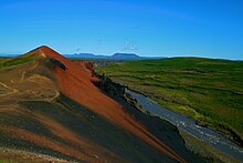
The Jökulsárgljúfur National Park, located on the lower reaches of the Jökulsá á Fjöllum glacier river , is also located in the municipality of Norðurþing. There is the row of craters Rauðhólar .
Former parishes
The former town of Húsavík (Isl. Húsavíkurbær ) on Skjálfandi Bay had 2,373 inhabitants (2005). In 2002 the rural community of Reykjahreppur was incorporated.
The former rural community Keldunes (isl. Kelduneshreppur ) on the south and west coast of the fjord Öxarfjörður had 100 inhabitants (2005). Agriculture is the main economic factor.
The former rural community Öxarfjörður (isl. Öxarfjarðarhreppur ) on the eastern edge of the fjord of the same name counted 330 inhabitants (2005) and included u. a. most of the Melrakkaslétta peninsula. The main town was Kópasker.
The former rural community Raufarhöfn (Isl. Raufarhafnarhreppur ) on the eastern edge of the Melrakkaslétta peninsula had 228 inhabitants (2005).
| Húsavík | Keldunes | Öxarfjörður | Raufarhöfn | |
|---|---|---|---|---|
| Municipality number: | 6100 | 6701 | 6702 | 6705 |
| Area in km²: | 269 | 736 | 2,687 | 37 |
| Population on Dec. 1, 1997: | 2,599 (territorial status 2002) | 100 | 395 | 381 |
| Population on Dec. 1, 2003: | 2,453 | 103 | 344 | 254 |
| Population on December 1st, 2004: | 2,426 | 103 | 331 | 238 |
| Population on Dec. 1, 2005: | 2,373 | 100 | 330 | 228 |
| Population change 1997-2005: | -9% | 0% | -16% | -40% |
| Post Code: | 640, 641 | 671 | 670, 671 | 675 |
Population development
Like most areas of Iceland now, apart from the southwest around the capital Reykjavík, the area of today's municipality of Norður Gemeindeing is suffering from population loss. From 1997 to 2006 the population decline was 13.0%.
| Year * | Residents |
|---|---|
| 1997 | 3,475 (area 2006) |
| 2003 | 3,154 (area 2006) |
| 2004 | 3,098 (area 2006) |
| 2005 | 3,031 (area status 2006) |
| 2006 | 3,023 |
* on December 1st
Sons and daughters of the church
- Skúli Magnússon (1711–1794), first Icelandic governor of Iceland
- Jón Trausti (1873-1918), writer
- Birgitta Haukdal (* 1979), pop singer
Web links
- Website of the municipality (Icelandic, English)
- Website of the former local government of Keldunes (Icelandic, English)
- Web presence of the former municipal administration of Raufarhöfn (Icelandic)
- Website of the former municipality of Öxarfjörður (Icelandic)
- To the natural treasures of the district (Icelandic) (PDF file; 2.58 MB)
- Pictures from the Arctic Monument (isl. Heimskautsgerðið ) in Raufarhöfn
