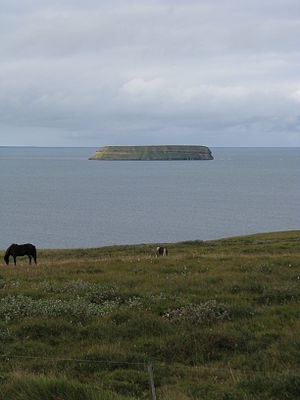
Skjalfandi
| Skjalfandi | ||
|---|---|---|
|
Lundey |
||
| Waters | Greenland Sea | |
| Land mass | Iceland | |
| Geographical location | 66 ° 6 ′ N , 17 ° 33 ′ W | |
|
|
||
| width | 33 km | |
| depth | 22 km | |
| Islands | Flatey , Lundey | |
| Tributaries | Laxá í Aðaldal , Skjálfandafljót | |
The Skjálfandi Bay is located in the north-east of Iceland .
Surname
The name means earthquake bay , (Isl. Skjálfandafljót or Skjálfandi , literally the trembling ). Here many crevices of the active volcanic zone of Þeistareykir extend over the Reykjafjöll and the Tjörnes peninsula into the sea, where the mid-Atlantic ridge continues undersea in the direction of the Kolbeinseyjar ridge . As is to be expected in such a zone, earthquakes are frequent, although mostly not noticeable to humans.
Geography and fauna
The almost uninhabited west side of the bay (part of the Flateyjarskagi peninsula ) with the Víknarfjöll and Kinnarfjöll is very mountainous, while the landscape of the east side, on which the town of Húsavík is characterized by the fishing and tourist port, is more dominated by hills. Two large rivers flow into the bay on the south side, the salmon river Laxá í Aðaldal , a source river, and the Skjálfandafljót , a glacial river. In the bay are the islands of Flatey and Lundey , whose name (dt. Puffin Island ) refers to the numerous puffins . The very nutrient-rich bay is also famous for the frequent appearing of whales of different sizes, which can be seen on whale watching trips .


