Mid-Atlantic Ridge
The Mid-Atlantic Ridge ( English Mid-Atlantic Ridge , abbreviated MAR ), and Mid-Atlantic threshold called, is a below the sea lying mountain range in the Atlantic Ocean and extends over approximately 20,000 km. This makes it the longest of the mid-ocean ridges , a system that spans the earth over 60,000 km.
geography
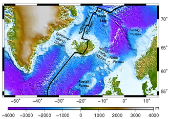
The S-shaped ridge extends from the Gakkel Ridge in the Arctic Ocean to Bouvet Island on the edge of the Atlantic-Indian southern polar basin off the Antarctic . It runs pretty much along the ocean center line and divides the Atlantic into a western and an eastern half. The Romanche Trench , which is up to 7730 meters deep, near the equator , divides the Mid-Atlantic Ridge into the North and South Atlantic Ridge , also known as the North and South Atlantic Sill .
The ridge of the Mid-Atlantic Ridge is on average about 1500 to 3000 meters below the water surface. Characteristic is its deep central trench, which runs from north to south in the longitudinal direction through the entire ridge. This rift valley was discovered in 1952 by a team led by Bruce Heezen and Marie Tharp and is 25 to 50 kilometers wide.

Transverse faults ( transform faults ) and parallel thresholds and ridges form a rough relief on the sea floor in the area of this mid-ocean ridge . The ridge is accompanied on its course through the Atlantic by numerous deep-sea basins adjoining to the west and east . From around Bouvet Island, the Mid-Atlantic Ridge goes eastwards with the Atlantic-Indian Ridge , which is considered the southern branch of the South Atlantic Ridge , into the southwest Indian Ridge of the Indian Ocean .
The Mid-Atlantic Ridge is still tectonically active; its formation is accompanied by an expansion of the sea floor, the ocean floor spreading . In the process of plate tectonics , both the North American and Eurasian plates move away from each other and the South American plate moves away from the African plate; the spreading rate averages about 2.5 cm per year. In the process, new ocean floor is constantly being formed, and the age of the sea floor increases with increasing distance from the central rift valley .

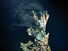
Various volcanic and hydrothermal formations are associated with magmatic activity in the area of the Mid-Atlantic Ridge . This also includes black and white smokers in deep sea regions, where hot water escapes with substances dissolved from the rock. They represent a niche for life forms that get by without photosynthesis and, for example, as chemoautotrophic bacteria, build up organic compounds by generating energy by oxidizing the escaped hydrogen sulfide .
Islands
Directly on the mid-Atlantic ridge are islands or archipelagos , which represent the highest elevations of this largely submarine mountain range. These are, from north to south, with their highest peaks (height in meters):
- Northern Hemisphere (North Atlantic Ridge)
- Jan Mayen (to Norway in the Arctic Ocean ( Beerenberg ), 2277 m), northern end point of the Kolbeinsee ridge
- Iceland ( Hvannadalshnúkur in Vatnajökull , 2110 m)
- Azores (to Portugal ) ( Ponta do Pico or Pico Alto, on the island of Pico , 2351 m, the highest point on the Mid-Atlantic Ridge)
- Rocks of Saint Peter and Saint Paul (in Brazil ) (Penedo Sudoeste, 22.5 m)
- Southern Hemisphere (South Atlantic Ridge)
- Ascension (to St. Helena ) (The Peak, Green Mountain, 859 m)
- St. Helena (to St. Helena ) (Diana's Peak, 823 m)
- Tristan da Cunha (to St. Helena ), ( Queen Mary's Peak , 2062 m)
- Gough Island (to St. Helena ) ( Edinburgh Peak , 909 m)
- Bouvet Island (to Norway ) ( Olavtoppen , 780 m)
See also
literature
- Robert Kunzig: The invisible continent. The discovery of the sea depth. Hamburg 2002, ISBN 978-3936384710 .
- Claude Riffaud, Xavier Le Pichon : Expedition "Famous". 3000 meters below the Atlantic. Kiepenheuer & Witsch, Cologne 1977, ISBN 3-462-01184-7 .
- National Geographic (Ed.): World Ocean Floor Map . 1981 ( overview and online access ).
Web links
- Plate tectonics using Iceland as an example
- Drilling the Mid-Atlantic Ridge: RRS James Cook cruise JC007 - Research trip to a gap in the earth's crust in the Fifteen-Twenty Fracture Zone (FTFZ)
Individual evidence
- ↑ Peter Giese (Ed.): Oceans and Continents . Spectrum of Science Verlag, Heidelberg 1987, ISBN 3-922508-24-3 , p. 21 .
- ↑ Understanding plate motions . Information from the USGS on plate tectonics, May 24, 2012, accessed on August 26, 2014
- ^ Digital Isochrons of the World's Ocean Floor. (No longer available online.) Archived from the original on January 11, 2010 ; Retrieved January 21, 2010 . Info: The archive link was inserted automatically and has not yet been checked. Please check the original and archive link according to the instructions and then remove this notice.


