Geography of Iceland
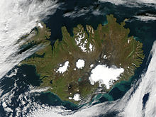
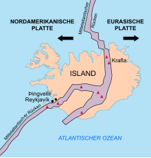
Iceland is a large island in the North Atlantic . It lies on the northeastern part of the Mid-Atlantic Ridge , known as the Reykjanes Ridge, and is the only larger part of this ridge that exceeds sea level.
The island is located just south of the Arctic Circle, around 250 km southeast of Greenland . The area of the island is 103,125 km², of which land area 100,329 km², water area 2,796 km².
The highest point on the island is Hvannadalshnúkur at 2,110 m. The longest rivers are the Þjórsá with 230 km and the Jökulsá á Fjöllum with 206 km.
geology
From a geological point of view, Iceland is one of the most interesting areas on earth, as several geological phenomena occur on the island at the same time and mutually influencing each other, thus offering a unique research area for volcanic plate tectonic processes.
plate tectonics
The mid-Atlantic ridge
Iceland is comparatively young at around 17 to 20 million years old. This is due to the location on the mid-Atlantic ridge .
Mid- ocean ridges (MOR for short), which also include the mid-Atlantic ridge, are places where the ocean floor is regularly renewed. By convection in the asthenosphere creates a divergent force on the ocean floor, as a result he "tears" and the resulting plan by nachfließendes Magma is filled (so-called " sea-floor spreading "). Over time, this creates an underwater mountain range.
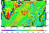
This phenomenon was confirmed by magnetic measurements, which showed strips of ocean floor with alternating polarity emanating from the MOR, aligned parallel to it and largely symmetrical on both sides . This alternating inverse and normal polarity of the ground comes from the phenomenon of the pole shift , through which the polarity of the earth's magnetic field is reversed approximately every 500,000 to 750,000 years . The exact causes that lead to the pole shift have not yet been researched. The basaltic magma, which is regularly extracted for the reasons mentioned above, contains mineral particles that, when cooled to form lavas, map the respective geomagnetic field in their magnetic alignment. When the magma cools down quickly when it comes into contact with water, conspicuous shapes such as pillow lavas and lava tubes are created .
It follows from the processes mentioned that the age of the ocean floor decreases with increasing proximity to the MOR. The same chronological and magnetic structure of the soil can also be found in Iceland, that is, Iceland is part of the Mid-Atlantic Ridge, which is the plate boundary between the Eurasian and North American plates . The ridge or central crevice (also called “rift”) occurring in the middle of a MOR can also be seen on land in Iceland, for example in the Þingvellir National Park , where it has even created a kind of natural amphitheater with the Almannagjá . The changing polarity of the ground can also be determined with a simple compass . In contrast to Madagascar , for example , a so-called “ microcontinent ”, Iceland is not made of continental crust material, but of purely oceanic origin. This can also be seen in the petrological composition of the island's rock, which mainly consists of basalts. The invading magmas are mostly mafic to intermediate with an SiO 2 content of 40–65%.
The age of the rocks is divided from west to east following the course of the Mid-Atlantic Ridge:
The area of the western and northwestern part of the island consists of tertiary basalt formations and is mostly older than 3 million years. An exception is Snæfellsnes , where volcanic activity first stopped 7 million years ago, but then started again 2 million years ago. The last eruptions took place in the area for land acquisition time to 900 instead (in Hnappadalur ). There are still 3 active volcanic systems there.
This is followed to the east by the Pleistocene rocks of the extinct volcanic zone at around 700,000 to 3 million years ago . The rocks of the volcanically active Mid-Atlantic Ridge are younger than 700,000 years and are constantly renewing themselves. To the east of the volcanically active zone is the eastern part of the extinct volcanic zone, also known as the “ gray basalt formation ”. Subsequently, there is another tertiary area, but to a lesser extent than in the west of the island.
Due to the constant volcanic activity as a result of the spreading tendencies of the Mid-Atlantic Ridge, Iceland is growing by approx. 2 cm per year in an east-west direction. However, growth in the west is significantly stronger than that in the east.
The Iceland Plume
In fact, there are only a few islands that are part of the 15,000 km long Mid-Atlantic Ridge: the Azores , the islands of St. Peter and St. Paul , Ascension , Tristan da Cunha , the Gough and Bouvet Islands and, to the north of Iceland, Jan Mayen . However, Iceland is by far the largest survey of a MOR worldwide in terms of area . This extraordinary position of Iceland is explained by the so-called Iceland-Plume (also: Manteldiapir ). This is a particularly strong and hot convection current in the asthenosphere below the island. Its origin is probably at the border between the earth's core and the earth's mantle at a depth of about 2880 km. However, it has existed much longer than Iceland, it is believed that the plume formed during the opening of the North Atlantic about 60 million years ago towards the end of the Paleocene under Greenland . In the region around Iceland, this mantle diapir leads to an elevation of the surrounding ocean floor due to its rising forces and thus to an elevation of the island above sea level. In addition, the hotter and stronger magma flow leads to increased volcanic activity, which promotes or accelerates the growth of the island. This is confirmed by geoid anomalies with Iceland in the center: the region around the island rises approx. 70 meters above the geodetic reference ellipsoid .
An alternative, controversial theory explains the anomaly by the presence of a greater amount of eclogite in the Earth's upper mantle, which at a given temperature produces more melt than the main mantle rock, peridotite .
Seismic activity
The steady growth of the island in western and eastern directions and the resulting tensions lead to numerous earthquakes . While there are a large number of so-called micro - earthquakes ( up to two dozen daily on the Reykjanes peninsula in southwest Iceland), very strong earthquakes are less common. The strongest earthquake detected in Iceland so far occurred on August 14, 1784 in the southwest of the island and had a magnitude of 8.0 on the Richter scale . This caused mountain slopes to slide and new geysers were created. Around 500 farms were destroyed or badly damaged and some people lost their lives.
It is noticeable that the epicentres of the earthquakes are mainly to be found in the southwest and northern parts of the island. This accumulation is explained by transform disturbances or leaf displacements of the Mid-Atlantic Ridge, which are located in these areas. These are dislocations of the MOR caused by shear forces . H. a displacement of parts of the MOR, which usually divide the back perpendicular to the stroke . Such zones are known as seismically active regions and are not very common.
Volcanism
Iceland is one of the most volcanically active areas on earth and therefore has a wealth of volcanic forms. This is partly due to the location on the Mid-Atlantic Ridge, and partly to the Icelandic Plume, which is located below Iceland.
Active volcanic zone
The active volcanic zone of Iceland is concentrated along the course of the plate boundary or the central fissure of the Mid-Atlantic Ridge, as fresh magma swells here. Active volcanoes are located in a neovolcanic zone only a few dozen kilometers wide (with the exception of the volcanoes on Snæfellsnes ), which consists of two branches in the southern half and one strip in the northern half. All three zones converge in the area of Vatnajökull . The old basalt fields in the west and east of the island can be traced back to the tertiary volcanism . As Iceland grew in an east-west direction, the volcanoes that existed there were gradually cut off from the central fissure of the MOR and inactive due to the lack of magma extraction. The same applies to the gray basalt formation of the inactive volcanic zone of the Old Pleistocene. The oldest basalts of the Pleistocene are still very similar to the tertiary ones. However, they contain more sediments , palagonites and moraine-like deposits ( tillites ), which document the glacial activity on Iceland.

Most of the active volcanoes are in the uninhabited Icelandic highlands . Areas in which one can observe the volcanic activity particularly well are z. B. Landmannalaugar in the south or the Krafla Caldera in the north of the island. Many of the volcanoes have glaciated peaks, so the following (with the glacier surfaces ):
- Vatnajökull (8,100 km²)
- Langjökull (953 km²)
- Hofsjökull (930 km²)
- Mýrdalsjökull (595 km²)
- Drangajökull (199 km²)
- Eyjafjallajökull (107 km²)
In front of the island are other volcanic islands ( Heimaey , Surtsey and others).
The last volcanic eruptions so far took place in 2000 ( Hekla ), 2004 ( Grímsvötn ), 2010 ( Eyjafjallajökull ), 2011 (Grímsvötn) and 2014 ( Bárðarbunga ).
There are many caves in the lava fields , both in the block lava fields and in the flat lava fields , which are called Hellishraun in Icelandic , in German the cave lava , but this has no scientific significance.
Pillow lavas, shield volcanoes and table mountains
During the cold times , when Iceland was buried under glaciers several hundred meters thick , a special form of volcanism developed. This mostly resulted in an effusive extraction of magma, whereby the heat melted the glacier in the outlet area of the magma. The high pressure of the ice and the rapid cooling through contact with water led to the formation of pillow lavas. The resulting pillow backs can be seen today, for example, on Sigalda in southern Iceland. If the magma production continued, the pressure gradually decreased, and so-called palagonite tuff was formed as a result of ash eruptions. If the volcano broke through the glacier, a shield volcano was created above the ice through effusive extraction . Shield volcanoes promote low-viscosity lavas, which are spread over a large area. Shield volcanoes therefore have a slope of only approx. 8 ° (e.g. Kjalhraun ). If the lava broke through the ice sheet of the glacier, basalt plateaus were formed . After the glacier had melted, a so-called tabular volcano with its characteristic steep walls remained (e.g. Herðubreið ).
Fissure eruptions and rows of craters
However, many other types of volcanoes are also represented in Iceland. Among other things, the crevice eruptions are common . Magma is ejected along a column of up to several kilometers in length. This happened so z. B. at the 30 km long volcanic fissure Eldgjá in the year 930 .
Gradually, the ejection activity mostly concentrates on certain areas. Small cones form here, which subsequently form entire chains of volcanoes, so-called crater rows, such as the Lakis Fissure in southern Iceland, where in 1783 a chain of craters with over a hundred vents was created over a length of approx. 25 km.
Other types of volcanoes
Stratovolcanoes only exist in very small numbers in Iceland. They extract large quantities of rhyolitic ashes and have a typical cone shape (e.g. Snæfellsjökull ).
The Hekla volcano has a unique shape and is considered a mixture between a crevice volcano and a stratovolcano.
Also Tuffringe can be found in Iceland. They were created by a unique eruption event , a phreatomagmatic explosion in which lava came into contact with water. The most famous example of this type of crater is Hverfjall on Lake Mývatn .
The so-called Eldborgir (fire castle) in Icelandic are weld cinder cones , which sometimes stand individually, like the Eldborg í Hnappadal, but also often in rows together with cinder cones on a volcanic crevice, as in the volcanic mountain range of the Bláfjöll near Reykjavík , at the craters of the Veiðivötn or the Laki craters .
Geysers
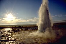
Another phenomenon of volcanic activity in Iceland is geysers and hot springs. There are around 600 major hot springs in Iceland. Spring springs, which are called geysers (Icelandic: geysa - swirl, flow), arise when they have a relatively narrow eruption channel. Leachate heated by magma is heated to well over 100 ° C due to the pressure of the water column in the eruption canal. Individual bubbles rise and force some of the water out. This causes the pressure to drop and the superheated water suddenly turns into steam. The subsequent eruption can throw the water well over a hundred meters into the air. However, such high breakouts are rare. Geysers usually do not exist for a long time because the eruption canal can be easily buried by landslides or earthquakes or the canal is widened by the eruption activity and therefore no longer enough pressure can be built up. The geyser then becomes a hot spring. On the other hand, they often arise from earthquake activity and the opening of new crevices. The most famous geysers in Iceland are the Strokkur Gysir and the Great Geyser .
The influence of water
glacier
Iceland is repeatedly called the island of fire and ice. Not without good reason, because in addition to the 33 active volcanic systems, there are various forms of water and not least the island's glaciers that have shaped them.
Cold and warm periods
The glaciers of the last Ice Age rested on Iceland until 10,000 years ago. However, there were already considerable climatic fluctuations, so that the glaciers expanded in the cold periods , but melted in the warm periods . During the cold periods, the whole country was covered with layers of ice that were up to 2,000 m thick. From around 10,000 to 2,500 years ago, the climate was then quite mild, warmer than it is now, and the ice layer melted. Then it got colder again relatively quickly and today's inland ice sheets like Vatnajökull were created. During the colonization of the country in the 9th and 10th centuries, it was a bit warmer than it is today. Then there was another cold period from the 13th to the end of the 19th century, which is now known as the Little Ice Age .
Glacial erosion
The glaciers are always in motion. They step and flow forward, constantly scraping the rock under them. They erode mountains in this way and created the trough valleys in the Akureyri area or the cirques in the walls of the Westfjords .
The valleys of narrow lakes like Skorradalsvatn and those of the fjords were also formed by the glaciers.
The fjords are always deeper towards the inland because here the glaciers rested longer and heavier and therefore their erosion could have a stronger effect.
Current situation
Currently about 8% of the country is covered by glaciers, the surface of which is shrinking due to global warming , like many glaciers in the world. For example, the largest Icelandic glacier, Vatnajökull, lost more than 10% of its volume in the past 100 years. It is believed that this could result in increased volcanic activity as the ice sheet on the volcanoes thins and the land lifts, creating new crevices and openings through which magma can rise. Similar phenomena are known from the end of the Ice Age - in Iceland about 10,000 years ago.
Rivers
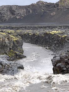
The rivers have also shaped Iceland, because they too are eroding the earth through the force of the flowing and raging water.
This can be seen, for example, in waterfalls such as Gullfoss , which literally gnawed into crevices created by the tectonic movements and widened and deepened them considerably.
A distinction is made between three basic types of rivers: the source rivers , the water level of which is more or less evenly high, such as the Hvítá in Borgarfjörður ; the glacier rivers such as the Skeiðará , whose water level is subject to very strong fluctuations, especially in summer, but also due to volcanic influences; the confluent rivers, which mainly absorb the water of other streams and rivers and can swell strongly, especially in thaw, such as Norðurá in Borgarfjörður.
Glacier rivers have a particularly strong erosion force. During the famous glacier run in 1996 , the Skeiðará carried huge amounts of rubble with it and shifted the coastline out into the sea. Rivers not only erode, they also build up.
sea
The North Atlantic around Iceland has tremendous power. Waves can tower up to 20 m high off the south coast.
At Dyrhólaey , for example, you can see how the rocks of the cape are gnawed and abraded by the sea every year. The sea has shaped coastlines into the mountains: in the south of the country you can see former capes everywhere. The river deposits, however, later shifted the coastline in the opposite direction.
But the sea doesn't just break down, it builds up. This can be clearly observed in the many peninsulas in the West Fjords called Eyri. Sandbanks were washed ashore there, on which numerous places such as Þingeyri or Flateyri stand today.
Wind erosion in Iceland
The location of the island of Iceland in the North Atlantic requires special climatic conditions. This means that the country is and was specifically shaped by storms.
One fights against constant soil erosion here , whereby the storm can become so strong that it actually folds up the asphalt on the streets or, by grinding it into tiny particles, sweeps it away.
Especially in areas where the soil and vegetation have already been attacked by overgrazing or the influence of water and volcanism, the winds have an easy time. They contributed and still contribute to the desert-like appearance of large stretches of land, especially in the interior of the island.
You can see this when you cross the island from north to south on one of the highland slopes such as the Sprengisandur , but also on the ring road in the highlands near Möðrudalur .
Wind erosion is most significant on the sand plains, where the glacier rivers such as the Skeiðará , Kúðafljót or Jökulsá á Fjöllum continually deliver deposits. In longer dry periods it can therefore z. For example , sandstorms occur on Mýrdalssandur or in the Möðrudalsöræfi desert . The sand is sometimes carried hundreds of kilometers through the air and can suddenly contribute to quite hazy air in Borgarfjörður , for example .
The wind erosion can, however, especially help palagonite rocks to form quite interesting shapes. B. can be seen in the smórsmörk .
There are hardly any dunes in Iceland, at most on beaches.
A striking feature of wind erosion and thus the destruction of fertile soil in Iceland are the so-called rofaborð (isl. Rof "erosion", rofaborð "erosion table "). Here, the wind, as we know it in German coastal landscapes, for example in dunes on Sylt , has already made use of fragile soil due to other erosion influences, and it is further eroding it. The result is a bump in the ground that looks like it has been pitted and only carries some grass at the top.
See also
- List of extreme points in Iceland
- Volcanoes in Iceland
- List of plateaus and mountain passes in Iceland
- List of rivers in Iceland
- List of lakes in Iceland
- List of fjords in Iceland
- List of cities in Iceland
- List of Icelandic islands
literature
- Einarsson, Þorleifur (1994): Geology of Iceland. Rocks and landscapes . 3rd German edition, Verlag Mál og Menning, Reykjavík, ISBN 9979-3-0690-4
- Gläßer, Ewald; Achim Schnütgen (1986): Iceland . Scientific Book Society Darmstadt (= Scientific Country Customers Volume 28), ISBN 3-534-01225-9 .
- Guðmundsson, Ari Trausti ; Kjartansson, Halldór (1996): Land im Werden. An outline of the geology of Iceland . Vaka-Helgafell, Reykjavík, ISBN 9979-2-0347-1
- Guðmundsson, Ari Trausti (1996): Volcanoes in Iceland. 10,000 Years of Volcanic History . Vaka-Helgafell, Reykjavík, ISBN 9979-2-0348-X
- Guðmundsson, Ari Trausti (2007): Living Earth. Facets of the geology of Iceland . Mál og Menning, Reykjavík, ISBN 978-9979-3-2778-3
- Hug-Fleck, Chris (2010): Iceland's natural wonders, portrait of an extraordinary volcanic island . Au, ISBN 978-3-00-030427-9
- Schönenberger, R .; J. Neugebauer (1987): Introduction to the geology of Europe . 5th edition, Rombach Wissenschaft, Freiburg
- Schutzbach, W. (1976): Iceland. Fire Island on the Arctic Circle . 2nd ed.; Ferd. Dümmlers Verlag, Bonn.
- Sonder, RA (1941): Studies on hot springs and tectonics in Iceland . Schweizer-Spiegel-Verlag, Zurich
- Thordarson, Thor; Hoskuldsson, Armann (2002): Iceland. Classic Geology in Europe 3 . Terra Publishing, Harpenden, ISBN 1-903544-06-8
- Zepp, H. (2002): Geomorphology . 3rd edition, (= UTB 2164), Schöningh
Web links
- Photos and videos
- Scientific contributions
To volcanism
- Overview of the volcano systems Islands (English)
- Temperature measurements of layers of earth in Iceland, scientific Art. Doi : 10.1016 / j.tecto.2006.02.027 (English)
- On the origin of volcanism in Iceland, scientific article (English, PDF file; 1.73 MB)
- Information on individual Icelandic volcanoes, Smithsonian Institute (English)
- Overview of the earthquake situation in March 2009, Isl. Wetteramt, the volcanic zones and volcanic systems are clearly recognizable, the red dots stand for earthquakes; the volcanic zone on Snæfellsnes is not marked in yellow
- Igneous types in Iceland, (English)
- Overview of the development of the volcanic zones ( Memento from July 19, 2013 in the Internet Archive ) (Page 3, English; PDF file)
- Leó Kristjánsson and Geirfinnur Jónsson: Aeromagnetic surveys off South and West Iceland in 1990–1992, Science Institute, University of Iceland (English)
- Erik Sturkell (Univ. Göteborg): Impact on crustal deformation. Magmatic and tectonic processes of glacier thinning due to climate change. (Relationship between glacier melt, activity of individual large volcanic systems and their impact on others)
- GR Foulger: Iceland and the North Atlantic igneous province , Dept. Geological Sciences, University of Durham, Durham DH1 3LE, UK, last updated 8th feb. 2005 (PDF file, English; 289 kB)
- Agust Gudmundsson: DYNAMICS OF VOLCANIC SYSTEMS IN ICELAND: Example of Tectonism and Volcanism at Juxtaposed Hot Spot and Mid-Ocean Ridge Systems , Annu. Rev. Earth Planet. Sci. 2000. 28: 107–40 (PDF file, English)
To the earthquakes
- Current earthquake situation (English)
- Judicael Decriem: The 2008 May 29 earthquake doublet in SW Iceland , Geophysical Journal International, 181, Issue 2, March 22, 2010 (PDF file)
- Overview of the earthquake situation in March 2009, Isl. Wetteramt, the volcanic zones and volcanic systems are clearly recognizable, the red dots stand for earthquakes; the volcanic zone on Snæfellsnes is not marked in yellow
Glaciology and Isostatic Compensation
- Univ. Iceland: Development of glaciers in relation to climate change (English, PDF file)
- Björn Lund, Peter Schmidt, Þóra Arnadóttir: How may Glacial Rebound influence seismic activity in Iceland? (Abstract) (English, PDF file; 17 kB)
- Ólafur Ingólfsson, ea: Rapid isostatic rebound in southwestern Iceland at the end of the last glaciation (Abstract) (English, PDF file)
- B. Lund, ea: Current glacial isostatic adjustment in Iceland , Geophysical Research Abstracts, Vol. 11, EGU 2009-7803, 2009 (Abstract, English, PDF file; 117 kB)
- Guðmundur E. Sigvaldason: Volcanic and tectonic processes coinciding with glaciation and crustal rebound: an early Holocene rhyolitic eruption in the Dyngjufjöll volcanic center and the formation of the Askja caldera, north Iceland. Received: April 24, 2001 / Accepted: January 12, 2002, Springer 2002 (PDF file, English)
Other
- Univ. Iceland: German scientific expeditions to Iceland, 1819–1970 (English, PDF file; 293 kB)
Individual evidence
- ^ Thordarson 2002, p. 8
- ↑ Univ.v.Island (Eng.)
