
Snæfellsnes
| Snæfellsnes | ||
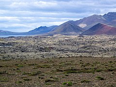
 West tip of Snæfellsnes with Svörtuloft lighthouse and a view of Snæfellsjökull in the background |
||
| Geographical location | ||
|
||
| Coordinates | 64 ° 51 ′ N , 23 ° 7 ′ W | |
| Waters 1 | Breiðafjörður (Atlantic Ocean) | |
| Waters 2 | Faxaflói (Atlantic Ocean) | |
| length | 107 km | |
| width | 35 km | |
| surface | 1 468 km² | |

The peninsula Snæfellsnes [ 'stn̥aiːfɛlsnɛs ] lies west of Borgarfjörður in west Iceland . The sparsely populated peninsula has numerous scenic beauties and has already been called the "Island in Miniature" because it reproduces all the charms of the big island in a very small area.
geography

Snæfellsnes is located between Faxaflói Bay and Breiðafjörður Fjord . The Snæfellsjökull lies at the tip of the peninsula, is a highly visible, 1,446 m high stratovolcano. Around it lies one of Iceland's four national parks, the Snæfellsjökull National Park . It has numerous marked hiking trails, e.g. B. an old road along the coast from Dritvík to Djúpalónssandur .
On the peninsula are the communities Snæfellsbær , Helgafellssveit , Grundarfjörður , Stykkishólmur and parts of Dalabyggð with their respective places.
In the vicinity of Hellissandur the Icelandic radio operates a transmission system for long wave . The Gufuskálar transmission mast belonging to this facility is 412 meters high and is likely to be the tallest structure in Western Europe.
geology
Approx. The basement in Snæfellsnes is 7 million years old or older. H. from the time when the plate boundaries and the active volcanic belt were in this area. Volcanic activity stopped on Snæfellsnes when the plate boundaries shifted 7 million years ago. For unknown reasons, however, it began again about 2 million years ago.
First there were volcanic eruptions in the Lýsuskarð volcanic system , which lies roughly in the middle of the peninsula, and 1 million years ago the Snæfellsjökuls and Ljósufjöll systems began to stir. The system of Ljósufjöll , which is located at the eastern end of the peninsula, is one of the longest active volcanic systems in Iceland with a remarkable length of over 90 km. It stretches from the Berserkjahraun lava field near Stykkishólmur to the Eldborg weld cinder cone in Hnappadalur on the way from Borgarnes to Snæfellsnes to the Grábrókkratern near Bifröst . The last eruptions on Snæfellsnes were around the time Iceland was colonized in the Hnappadalur.
Surname
The name of the peninsula means the Schneeberg Peninsula . Isl. Snæfell = snow mountain . isl. fell = mountain, isl. snær is a synonym for snjór = German snow. Isl. Nes = dt. Headland peninsula .
In this case, reference is made to the mountain Snæfellsjökull at the tip of the peninsula, which in older texts was often called Snjófell , e.g. B. in the book by the researchers Eggert Ólafsson and Bjarni Pálsson . Today it is called Snæfellsjökull, i. H. the Schneeberg glacier , also to distinguish two other mountains with the name Snæfell , which are located in East Iceland near Kárahnjúkar and on the southern edge of Vatnajökull .
literature
- Ari Trausti Guðmundsson , Living Earth. Facets of the geology of Iceland. Reykjavík, Mál og Menning, 2007.
- Thor Thordarsson, Ármann Höskuldsson: Iceland. Classic Geology in Europe 3. Harpenden, Terra, 2002, p. 162 ff.
Individual evidence
- ^ Ari Trausti Guðmundsson, pp. 90f.
- ↑ Árni Böðvarsson: Íslenzk orðabók handa skólum og almenningi. Reykjavík 1963. , p. 634.
- ^ Translations into German according to: Hans U. Schmid: Dictionary Icelandic-German . Hamburg 2001
- ↑ Einar Haukur Kristjánsson: Ferðafélag Íslands, Árbók 1982. Lýsing Snæfellsness frá Löngufjörum að Ólafsvíkurenni . OO 1982, p. 142
photos

Kálfárvellir waterfall
Berserkjahraun seen from the west

Hellissandur - view to Snæfellsjökull
.jpg)


Web links
Photos and videos
Knowledge Treatises
- Risk studies at Snæfellsjökull, Univ. v. Iceland, engl.
- S. Flude, R. Burgess, DW McGarvie: Silicic volcanism at Ljósufjöll, Iceland: Insights into evolution and eruptive history from Ar – Ar dating. In: Journal of Volcanology and Geothermal Research. 169, 2008, p. 154, doi : 10.1016 / j.jvolgeores.2007.08.019 .
- F. Fuchs, ea: Seismicity revealed in the Snaefellsnes Volcanic Zone, Iceland , EGU General Assembly 2012, held April 22-27, 2012 in Vienna, Austria., P.9808 (PDF, English; 36 kB)
- Geologist Haraldur Sigurðsson's blog on Snæfellsnes (Icelandic)