Hnappadalur
Coordinates: 64 ° 50 ′ N , 22 ° 21 ′ W
The Hnappadalur is a volcanic valley in the west of Iceland .
geography
The bowl-shaped valley lies in the south of the Snæfellsnes peninsula and at the foot of the central volcano of Ljósufjöll . It is located in the northwest of the municipality of Borgarbyggð . To the north of the valley are the two lakes Oddastaðavatn and Hlíðavatn , and to the east is lake Hítarvatn .
The landscape was shaped by the glaciers of the Ice Age and the volcanic eruptions of the Ljósufjöll system.
The oldest rock layers date back to around 7-10 million years ago. Ice-age glaciers lay over the area again and again. These receded from the sea, so that the valley was at times a fjord . Later this silted up.
The Ljósufjöll volcanic system had a decisive influence on the area. There are an unusually large number of volcanic craters in the valley. In the central volcano of the Ljósufjöll itself there is rhyolite , otherwise basalt rock.
The Haffjarðará river crosses the valley from northeast to southwest. It is one of the better known salmon rivers in Iceland.
Eldborg í Hnappadal
The crater Eldborg í Hnappadal (also: Eldborg á Mýrum ) is a sweat cinder cone (or lava ring) and is one of the most beautiful in Iceland. It is about 40 km north of Borgarnes and west of road no.50 which leads out to Snæfellsnes at this position . Eldborg is a general term for welding cinder cones in Iceland and literally means “ fire castle” .
The main crater measures approx. 200 m in diameter, is 50 m deep and has very steep walls inside and outside. There are three smaller craters nearby.
Eldborg is also mentioned in Landnámabók . It was believed in the Middle Ages that it erupted around 1,000 years ago at the time of the conquest . However, this has proven to be incorrect. The last eruption of Eldborg occurred around 5,000 - 9,000 years ago and created the Eldborgarhraun lava field . Today it is assumed that the lava fields from the time of the conquest of the land come from another crater in the Hnappadalur, probably from Rauðakúla .
Gullborg
The volcanic crater Gullborg is located about 15 kilometers north of Eldborg in its own lava field, which is less easily accessible, but has some large caves that are under nature protection. The longest cave, Borgarhellir , is 423 m long. The lava field is around 2,000 to 3,000 years old.
The first cave was only explored on July 28, 1969 by Guðmundur Albertsson from Heggstaðir Farm. Over the next few days he and others found even more caves in the Gullborgarhraun lava field .
More volcanic manifestations
Two other large craters near the central volcano of Ljósufjöll both bear the name Rauðakúla . The higher one is (917 m) high, the smaller one about 200 m lower.
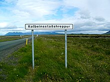
Two other cinder cones are Syðri-Rauðamelskúla (154 m) and Ytri-Rauðamelskúla (222 m). Syðri-Rauðamelskúla is more or less in the middle of the valley, Ytri-Rauðamelskúla further west near the abandoned Gerðuberg farm . Both can be climbed. From them you have a beautiful view of the valley and its various volcanic forms. The lava flows surrounding the craters are around 2,600 years old.
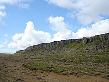
The basalt columns of Gerðuberg near Ytri-Rauðamelskúla were created by lava cooled by the sea from craters belonging to this volcanic system.
Not far from there is also a mineral spring to which a marked hiking trail leads: Rauðamelsölkelda .
Towards the end of the valley, in the direction of Borgarnes, there is another larger crater called Barnaborg in its own lava field. Another marked hiking trail leads through this Barnaborgarhraun to the crater (hiking car park on road 54).
history
The first settler in the valley, known as Knappadalur in the Middle Ages , was a man called Þorgils knocki . The valley is named after him.
Individual evidence
- ↑ cf. Þorleifur Einarsson: Þættir um jarðfræði Hnappadalssýslu . In: Guðlaugur Jónsson: Hnappadalssýsla. Ferðafélag Íslands. Árbók 1970, p. 106.
- ↑ Ísland Vegaatlas. Reykjavík 2006, p. 13
- ↑ http://angling.is/en/waters/salmon-rivers/on-the-west-coast/6546/ Accessed: December 27, 2010
- ↑ "En um nóttina kom þar upp jarðeldur, og brann þá Borgarhraun. Þar var bærinn, sem nú er borgin." (German / own translation: "But at night there was a volcanic eruption and the Borgarhraun lava field burned. There was a courtyard where there is now a crater.") Landnámabók, Chapter 5, cited above. in: Ferðafélag Íslands. Árbók 1970, Hnappadalssýsla . P. 25.
- ^ J. Willhardt, Chr. Sadler, Iceland . Gain. 2003, p. 566.
- ↑ Guðlaugur Jónsson: Hnappadalssýsla. Ferðafélag Íslands. Árbók 1970, p. 32f.
- ↑ Ólafur Lárusson, Snæfellsnes I , p. 72.


